Tiptop Topo Map Washington
To zoom in, hover over the map of Tiptop
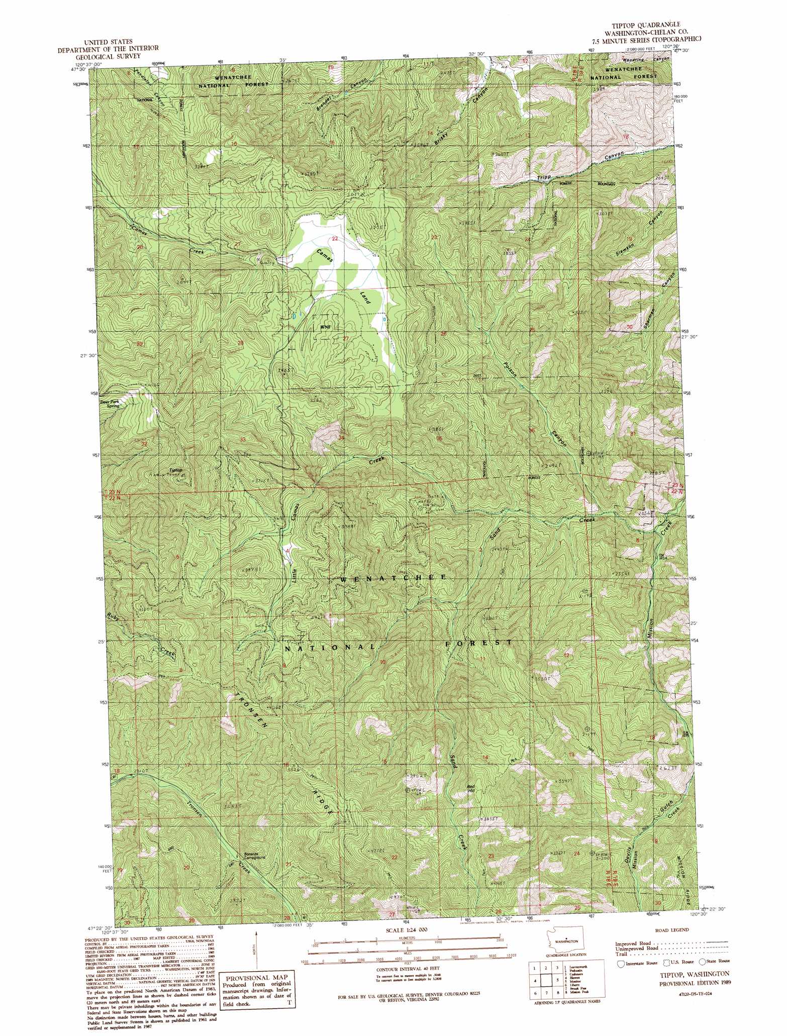
USGS Topo Quad 47120d5 - 1:24,000 scale
| Topo Map Name: | Tiptop |
| USGS Topo Quad ID: | 47120d5 |
| Print Size: | ca. 21 1/4" wide x 27" high |
| Southeast Coordinates: | 47.375° N latitude / 120.5° W longitude |
| Map Center Coordinates: | 47.4375° N latitude / 120.5625° W longitude |
| U.S. State: | WA |
| Filename: | o47120d5.jpg |
| Download Map JPG Image: | Tiptop topo map 1:24,000 scale |
| Map Type: | Topographic |
| Topo Series: | 7.5´ |
| Map Scale: | 1:24,000 |
| Source of Map Images: | United States Geological Survey (USGS) |
| Alternate Map Versions: |
Tiptop WA 1989 Download PDF Buy paper map Tiptop WA 2003, updated 2006 Download PDF Buy paper map Tiptop WA 2011 Download PDF Buy paper map Tiptop WA 2014 Download PDF Buy paper map |
| FStopo: | US Forest Service topo Tiptop is available: Download FStopo PDF Download FStopo TIF |
1:24,000 Topo Quads surrounding Tiptop
Big Jim Mountain |
Winton |
Van Creek |
Chumstick Mountain |
Ardenvoir |
Cashmere Mountain |
Leavenworth |
Peshastin |
Cashmere |
Rocky Reach Dam |
Enchantment Lakes |
Blewett |
Tiptop |
Monitor |
Wenatchee |
Red Top Mountain |
Liberty |
Swauk Pass |
Mission Peak |
Wenatchee Heights |
Teanaway |
Swauk Prairie |
Reecer Canyon |
Naneum Canyon |
Colockum Pass |
> Back to 47120a1 at 1:100,000 scale
> Back to 47120a1 at 1:250,000 scale
> Back to U.S. Topo Maps home
Tiptop topo map: Gazetteer
Tiptop: Flats
Camas Land elevation 875m 2870′Tiptop: Ridges
Tronsen Ridge elevation 1494m 4901′Tiptop: Springs
Deer Park Spring elevation 1269m 4163′Tiptop: Streams
East Fork Mission Creek elevation 533m 1748′Little Camas Creek elevation 535m 1755′
Sand Creek elevation 446m 1463′
Tiptop: Summits
Red Hill elevation 1171m 3841′Tiptop elevation 1349m 4425′
Tiptop: Trails
Red Hill Trail elevation 937m 3074′Ruby Creek Trail elevation 1063m 3487′
Tiptop Mount Lillian Trail elevation 1312m 4304′
West Sand Creek Trail elevation 1002m 3287′
Tiptop: Valleys
Devils Gulch elevation 565m 1853′Poison Canyon elevation 485m 1591′
Tiptop digital topo map on disk
Buy this Tiptop topo map showing relief, roads, GPS coordinates and other geographical features, as a high-resolution digital map file on DVD: