Mount Clifty Topo Map Washington
To zoom in, hover over the map of Mount Clifty
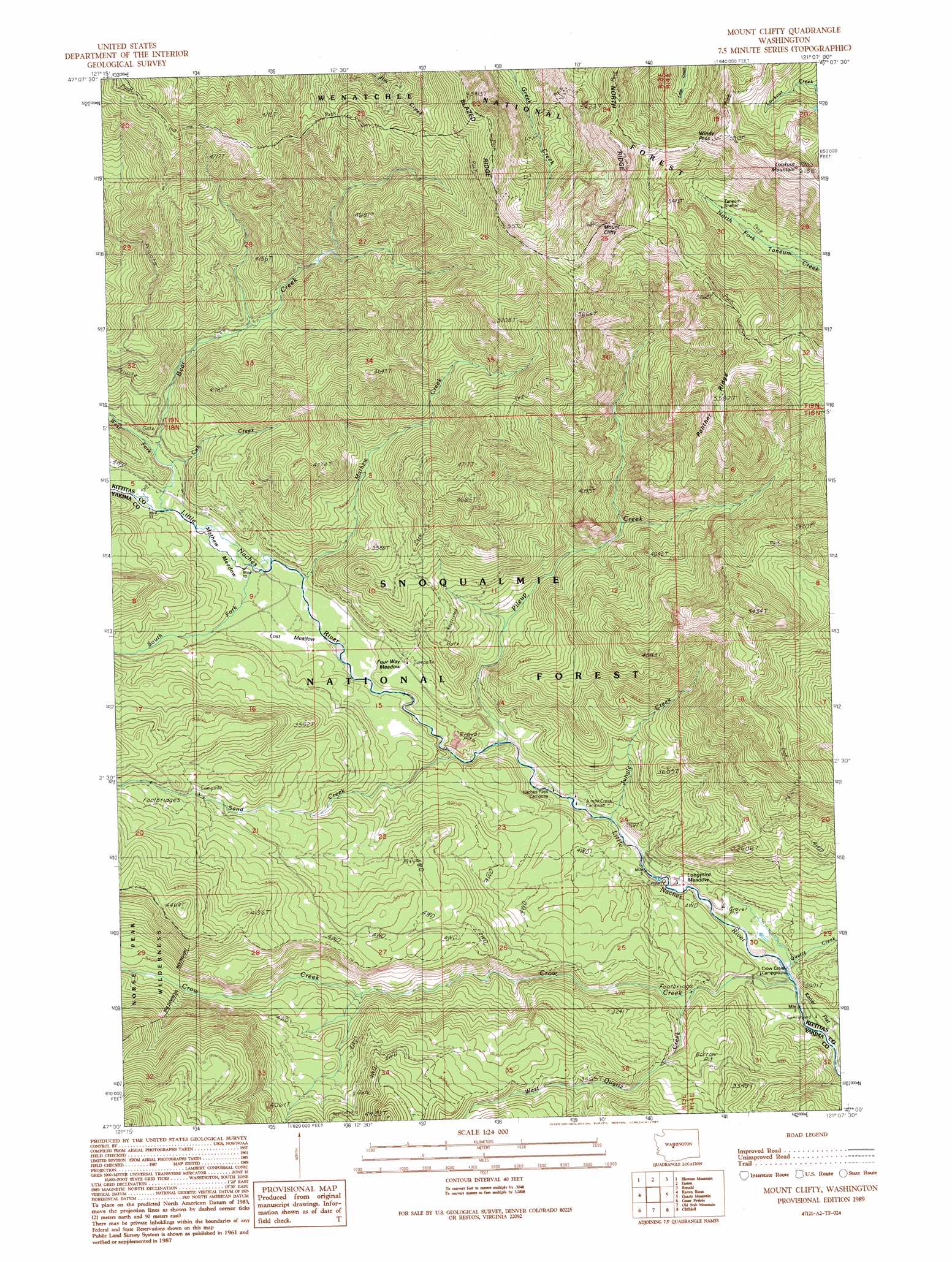
USGS Topo Quad 47121a2 - 1:24,000 scale
| Topo Map Name: | Mount Clifty |
| USGS Topo Quad ID: | 47121a2 |
| Print Size: | ca. 21 1/4" wide x 27" high |
| Southeast Coordinates: | 47° N latitude / 121.125° W longitude |
| Map Center Coordinates: | 47.0625° N latitude / 121.1875° W longitude |
| U.S. State: | WA |
| Filename: | o47121a2.jpg |
| Download Map JPG Image: | Mount Clifty topo map 1:24,000 scale |
| Map Type: | Topographic |
| Topo Series: | 7.5´ |
| Map Scale: | 1:24,000 |
| Source of Map Images: | United States Geological Survey (USGS) |
| Alternate Map Versions: |
Mount Clifty WA 2011 Download PDF Buy paper map Mount Clifty WA 2014 Download PDF Buy paper map |
| FStopo: | US Forest Service topo Mount Clifty is available: Download FStopo PDF Download FStopo TIF |
1:24,000 Topo Quads surrounding Mount Clifty
Lost Lake |
Stampede Pass |
Kachess Lake |
Cle Elum Lake |
Teanaway Butte |
Lester |
Blowout Mountain |
Easton |
Ronald |
Cle Elum |
Noble Knob |
Raven Roost |
Mount Clifty |
Quartz Mountain |
Frost Mountain |
Norse Peak |
Goose Prairie |
Old Scab Mountain |
Cliffdell |
Manastash Lake |
Cougar Lake |
Bumping Lake |
Timberwolf Mountain |
Meeks Table |
Nile |
> Back to 47121a1 at 1:100,000 scale
> Back to 47120a1 at 1:250,000 scale
> Back to U.S. Topo Maps home
Mount Clifty topo map: Gazetteer
Mount Clifty: Falls
West Quartz Creek Falls elevation 920m 3018′Mount Clifty: Flats
Kaner Flat elevation 821m 2693′Longmire Meadow elevation 852m 2795′
Lost Meadow elevation 950m 3116′
Mathew Meadow elevation 942m 3090′
Mount Clifty: Gaps
Windy Pass elevation 1613m 5291′Mount Clifty: Ridges
Panther Ridge elevation 1661m 5449′Mount Clifty: Streams
Bear Creek elevation 963m 3159′Crow Creek elevation 824m 2703′
Cub Creek elevation 962m 3156′
Jungle Creek elevation 864m 2834′
Mathew Creek elevation 937m 3074′
Pileup Creek elevation 876m 2874′
Quartz Creek elevation 832m 2729′
Sand Creek elevation 890m 2919′
South Fork Little Naches River elevation 940m 3083′
West Fork Bear Creek elevation 963m 3159′
West Quartz Creek elevation 856m 2808′
Mount Clifty: Summits
Lookout Mountain elevation 1880m 6167′Mount Clifty elevation 1826m 5990′
Mount Clifty: Trails
Granite Creek Trail elevation 1493m 4898′Manastash Ridge Trail elevation 1699m 5574′
Mount Cliffty Trail elevation 1413m 4635′
Mount Clifty digital topo map on disk
Buy this Mount Clifty topo map showing relief, roads, GPS coordinates and other geographical features, as a high-resolution digital map file on DVD: