Chester Morse Lake Topo Map Washington
To zoom in, hover over the map of Chester Morse Lake
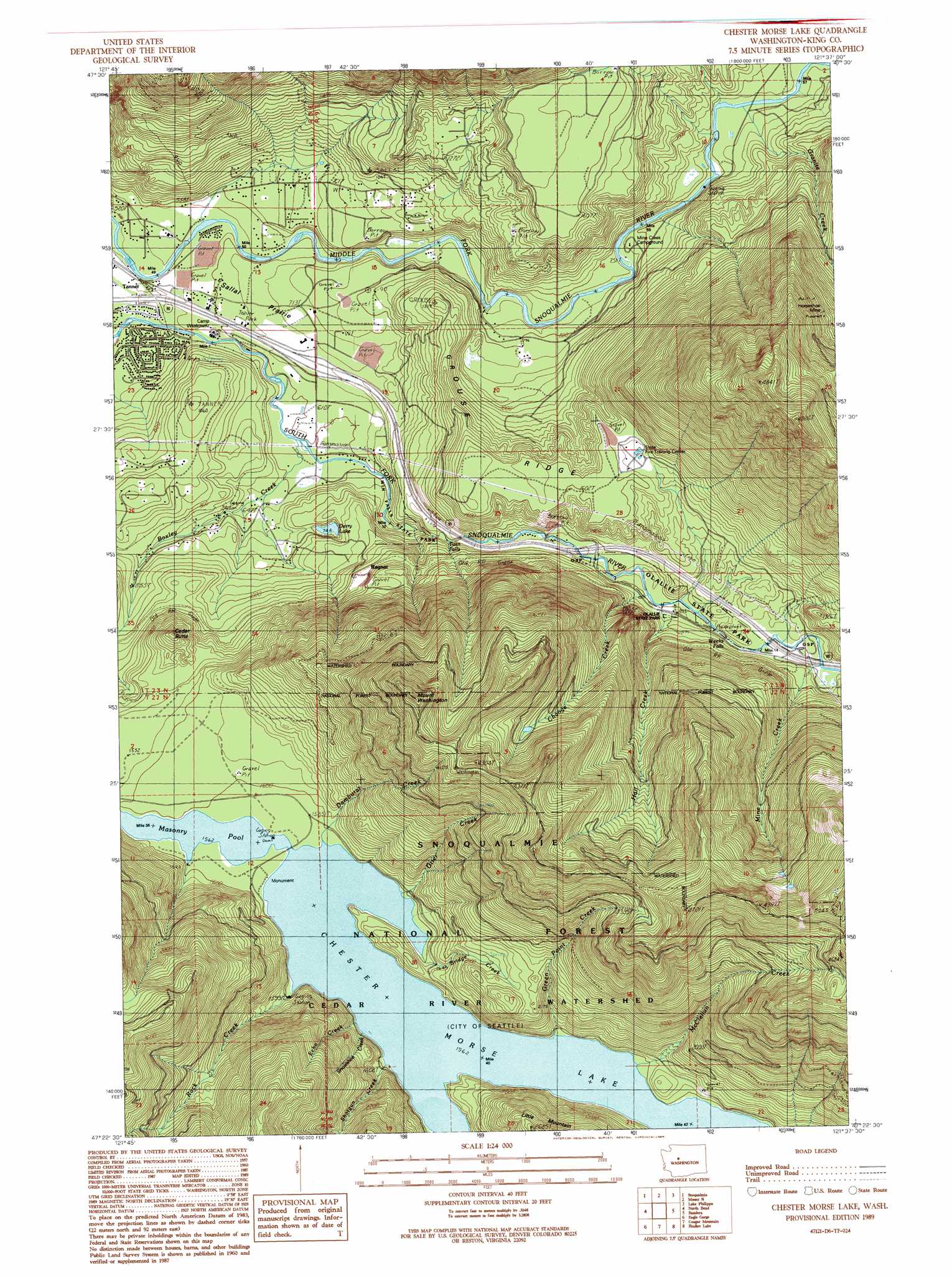
USGS Topo Quad 47121d6 - 1:24,000 scale
| Topo Map Name: | Chester Morse Lake |
| USGS Topo Quad ID: | 47121d6 |
| Print Size: | ca. 21 1/4" wide x 27" high |
| Southeast Coordinates: | 47.375° N latitude / 121.625° W longitude |
| Map Center Coordinates: | 47.4375° N latitude / 121.6875° W longitude |
| U.S. State: | WA |
| Filename: | o47121d6.jpg |
| Download Map JPG Image: | Chester Morse Lake topo map 1:24,000 scale |
| Map Type: | Topographic |
| Topo Series: | 7.5´ |
| Map Scale: | 1:24,000 |
| Source of Map Images: | United States Geological Survey (USGS) |
| Alternate Map Versions: |
Chester Morse Lake WA 1989, updated 1989 Download PDF Buy paper map Chester Morse Lake WA 2011 Download PDF Buy paper map Chester Morse Lake WA 2014 Download PDF Buy paper map |
| FStopo: | US Forest Service topo Chester Morse Lake is available: Download FStopo PDF Download FStopo TIF |
1:24,000 Topo Quads surrounding Chester Morse Lake
Carnation |
Lake Joy |
Tolt Reservoir |
Mount Phelps |
Grotto |
Fall City |
Snoqualmie |
Mount Si |
Lake Philippa |
Snoqualmie Lake |
Hobart |
North Bend |
Chester Morse Lake |
Bandera |
Snoqualmie Pass |
Cumberland |
Eagle Gorge |
Cougar Mountain |
Findley Lake |
Lost Lake |
Enumclaw |
Cyclone Creek |
Greenwater |
Nagrom |
Lester |
> Back to 47121a1 at 1:100,000 scale
> Back to 47120a1 at 1:250,000 scale
> Back to U.S. Topo Maps home
Chester Morse Lake topo map: Gazetteer
Chester Morse Lake: Airports
North Bend Airstrip elevation 204m 669′Chester Morse Lake: Dams
Crib Dam elevation 477m 1564′Chester Morse Lake: Falls
Twin Falls elevation 265m 869′Chester Morse Lake: Flats
Sallal Prairie elevation 197m 646′Chester Morse Lake: Lakes
Derry Lake elevation 228m 748′Chester Morse Lake: Mines
Horseshoe Mine elevation 919m 3015′Chester Morse Lake: Parks
Chester Morse Monument elevation 500m 1640′Twin Falls State Park elevation 189m 620′
Chester Morse Lake: Populated Places
Edgewick elevation 197m 646′Ragnar elevation 387m 1269′
Tanner elevation 159m 521′
Chester Morse Lake: Reservoirs
Chester Morse Lake elevation 477m 1564′Chester Morse Lake: Ridges
Grouse Ridge elevation 490m 1607′Chester Morse Lake: Streams
Boxley Creek elevation 179m 587′Bridge Creek elevation 477m 1564′
Change Creek elevation 368m 1207′
Damburat Creek elevation 477m 1564′
Echo Creek elevation 491m 1610′
Granite Creek elevation 253m 830′
Green Point Creek elevation 477m 1564′
Hall Creek elevation 367m 1204′
McClellan Creek elevation 477m 1564′
Mine Creek elevation 403m 1322′
Otter Creek elevation 477m 1564′
Rack Creek elevation 477m 1564′
Rex River elevation 477m 1564′
Shotgun Creek elevation 477m 1564′
Snowshoe Creek elevation 480m 1574′
Chester Morse Lake: Summits
Cedar Butte elevation 572m 1876′Mount Washington elevation 1344m 4409′
Chester Morse Lake digital topo map on disk
Buy this Chester Morse Lake topo map showing relief, roads, GPS coordinates and other geographical features, as a high-resolution digital map file on DVD: