Mount Si Topo Map Washington
To zoom in, hover over the map of Mount Si
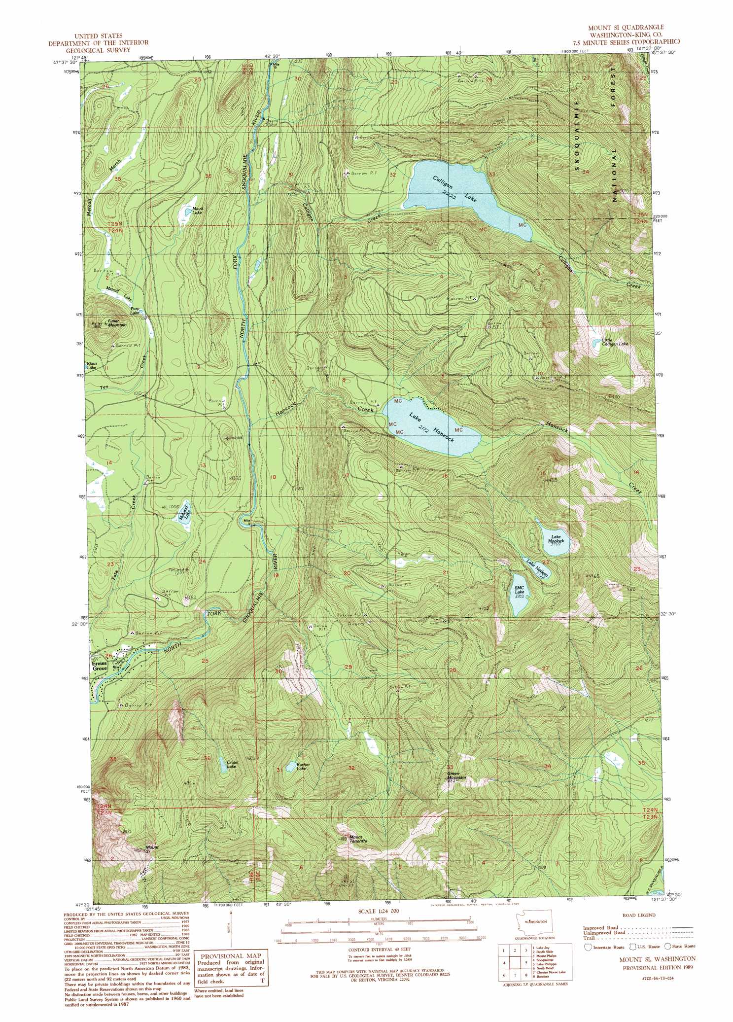
USGS Topo Quad 47121e6 - 1:24,000 scale
| Topo Map Name: | Mount Si |
| USGS Topo Quad ID: | 47121e6 |
| Print Size: | ca. 21 1/4" wide x 27" high |
| Southeast Coordinates: | 47.5° N latitude / 121.625° W longitude |
| Map Center Coordinates: | 47.5625° N latitude / 121.6875° W longitude |
| U.S. State: | WA |
| Filename: | o47121e6.jpg |
| Download Map JPG Image: | Mount Si topo map 1:24,000 scale |
| Map Type: | Topographic |
| Topo Series: | 7.5´ |
| Map Scale: | 1:24,000 |
| Source of Map Images: | United States Geological Survey (USGS) |
| Alternate Map Versions: |
Mount Si WA 1989, updated 1989 Download PDF Buy paper map Mount Si WA 2011 Download PDF Buy paper map Mount Si WA 2014 Download PDF Buy paper map |
| FStopo: | US Forest Service topo Mount Si is available: Download FStopo PDF Download FStopo TIF |
1:24,000 Topo Quads surrounding Mount Si
Monroe |
Sultan |
Gold Bar |
Index |
Baring |
Carnation |
Lake Joy |
Tolt Reservoir |
Mount Phelps |
Grotto |
Fall City |
Snoqualmie |
Mount Si |
Lake Philippa |
Snoqualmie Lake |
Hobart |
North Bend |
Chester Morse Lake |
Bandera |
Snoqualmie Pass |
Cumberland |
Eagle Gorge |
Cougar Mountain |
Findley Lake |
Lost Lake |
> Back to 47121e1 at 1:100,000 scale
> Back to 47120a1 at 1:250,000 scale
> Back to U.S. Topo Maps home
Mount Si topo map: Gazetteer
Mount Si: Lakes
Calligan Lake elevation 678m 2224′Crater Lake elevation 1016m 3333′
Fury Lake elevation 312m 1023′
Lake Hancock elevation 663m 2175′
Lake Moolock elevation 1191m 3907′
Lake Nadeau elevation 1136m 3727′
Little Calligan Lake elevation 827m 2713′
Maud Lake elevation 353m 1158′
McLeod Lake elevation 312m 1023′
Metcalf Lake elevation 314m 1030′
Rachor Lake elevation 1065m 3494′
SMC Lake elevation 1130m 3707′
Mount Si: Populated Places
Ernies Grove elevation 141m 462′Mount Si: Streams
Calligan Creek elevation 337m 1105′Hancock Creek elevation 311m 1020′
Mount Si: Summits
Fuller Mountain elevation 567m 1860′Green Mountain elevation 1431m 4694′
Mount Si elevation 1254m 4114′
Mount Teneriffe elevation 1444m 4737′
Mount Si: Swamps
Metcalf Marsh elevation 318m 1043′Mount Si digital topo map on disk
Buy this Mount Si topo map showing relief, roads, GPS coordinates and other geographical features, as a high-resolution digital map file on DVD: