Fall City Topo Map Washington
To zoom in, hover over the map of Fall City
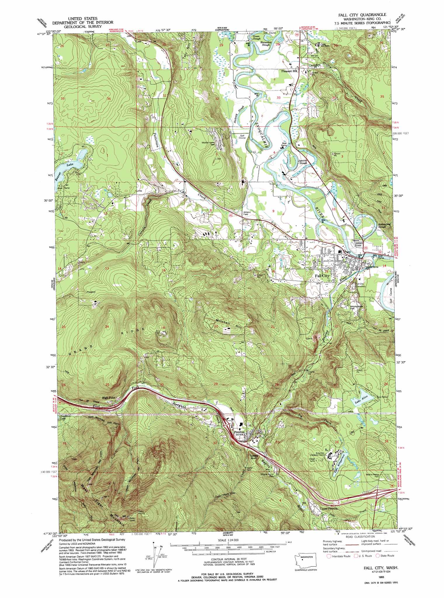
USGS Topo Quad 47121e8 - 1:24,000 scale
| Topo Map Name: | Fall City |
| USGS Topo Quad ID: | 47121e8 |
| Print Size: | ca. 21 1/4" wide x 27" high |
| Southeast Coordinates: | 47.5° N latitude / 121.875° W longitude |
| Map Center Coordinates: | 47.5625° N latitude / 121.9375° W longitude |
| U.S. State: | WA |
| Filename: | o47121e8.jpg |
| Download Map JPG Image: | Fall City topo map 1:24,000 scale |
| Map Type: | Topographic |
| Topo Series: | 7.5´ |
| Map Scale: | 1:24,000 |
| Source of Map Images: | United States Geological Survey (USGS) |
| Alternate Map Versions: |
Fall City WA 1953, updated 1955 Download PDF Buy paper map Fall City WA 1953, updated 1963 Download PDF Buy paper map Fall City WA 1953, updated 1970 Download PDF Buy paper map Fall City WA 1953, updated 1976 Download PDF Buy paper map Fall City WA 1953, updated 1985 Download PDF Buy paper map Fall City WA 1993, updated 1993 Download PDF Buy paper map Fall City WA 2011 Download PDF Buy paper map Fall City WA 2014 Download PDF Buy paper map |
1:24,000 Topo Quads surrounding Fall City
Bothell |
Maltby |
Monroe |
Sultan |
Gold Bar |
Redmond |
Carnation |
Lake Joy |
Tolt Reservoir |
|
Issaquah |
Fall City |
Snoqualmie |
Mount Si |
|
Renton |
Maple Valley |
Hobart |
North Bend |
Chester Morse Lake |
Auburn |
Black Diamond |
Cumberland |
Eagle Gorge |
Cougar Mountain |
> Back to 47121e1 at 1:100,000 scale
> Back to 47120a1 at 1:250,000 scale
> Back to U.S. Topo Maps home
Fall City topo map: Gazetteer
Fall City: Cliffs
Teaters Bluff elevation 166m 544′Fall City: Crossings
Interchange 20 elevation 146m 479′Interchange 22 elevation 170m 557′
Interchange 25 elevation 281m 921′
Fall City: Dams
Pattie Prince Dam elevation 269m 882′Preston Mill Pond Dam elevation 126m 413′
Fall City: Guts
Green Slough elevation 23m 75′Horseshoe Slough elevation 21m 68′
Rutherford Slough elevation 26m 85′
Stickney Slough elevation 23m 75′
Fall City: Lakes
Beaver Lake elevation 126m 413′Beaver Lakes elevation 126m 413′
Janicke Slough elevation 21m 68′
Lake Alice elevation 266m 872′
Fall City: Mines
Reynolds Mine elevation 163m 534′Fall City: Parks
Fall City Community Park elevation 28m 91′Fall City: Populated Places
Fall City elevation 32m 104′High Point elevation 160m 524′
Pleasant Hill elevation 33m 108′
Preston elevation 131m 429′
Upper Preston elevation 182m 597′
Fall City: Reservoirs
Lake Kittyprince elevation 269m 882′Preston Mill Pond elevation 126m 413′
Fall City: Ridges
Grand Ridge elevation 353m 1158′Fall City: Streams
Canyon Creek elevation 29m 95′Griffin Creek elevation 19m 62′
Haywitch Creek elevation 25m 82′
Icy Creek elevation 108m 354′
Lake Creek elevation 164m 538′
Patterson Creek elevation 24m 78′
Raging River elevation 26m 85′
Soderman Creek elevation 124m 406′
Fall City: Summits
Mitchell Hill elevation 396m 1299′West Tiger Mountain elevation 891m 2923′
Fall City digital topo map on disk
Buy this Fall City topo map showing relief, roads, GPS coordinates and other geographical features, as a high-resolution digital map file on DVD: