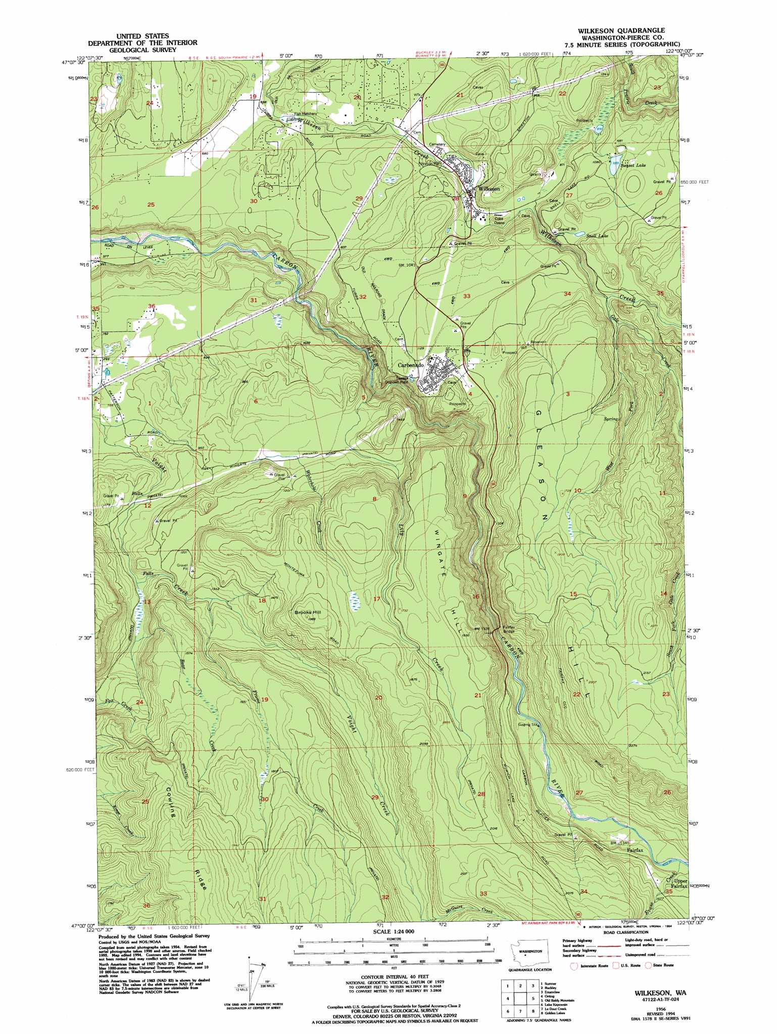
Wilkeson Topo Map Washington
To zoom in, hover over the map of Wilkeson
USGS Topo Quad 47122a1 - 1:24,000 scale
| Topo Map Name: | Wilkeson |
| USGS Topo Quad ID: | 47122a1 |
| Print Size: | ca. 21 1/4" wide x 27" high |
| Southeast Coordinates: | 47° N latitude / 122° W longitude |
| Map Center Coordinates: | 47.0625° N latitude / 122.0625° W longitude |
| U.S. State: | WA |
| Filename: | o47122a1.jpg |
| Download Map JPG Image: | Wilkeson topo map 1:24,000 scale |
| Map Type: | Topographic |
| Topo Series: | 7.5´ |
| Map Scale: | 1:24,000 |
| Source of Map Images: | United States Geological Survey (USGS) |
| Alternate Map Versions: |
Wilkeson WA 1956, updated 1958 Download PDF Buy paper map Wilkeson WA 1956, updated 1969 Download PDF Buy paper map Wilkeson WA 1956, updated 1994 Download PDF Buy paper map Wilkeson WA 2011 Download PDF Buy paper map Wilkeson WA 2014 Download PDF Buy paper map |
1:24,000 Topo Quads surrounding Wilkeson
Poverty Bay |
Auburn |
Black Diamond |
Cumberland |
Eagle Gorge |
Puyallup |
Sumner |
Buckley |
Enumclaw |
Cyclone Creek |
Frederickson |
Orting |
Wilkeson |
Old Baldy Mountain |
Bearhead Mountain |
Tanwax Lake |
Lake Kapowsin |
Le Dout Creek |
Golden Lakes |
Mowich Lake |
Eatonville |
Elbe |
Ashford |
Mount Wow |
Mount Rainier West |
> Back to 47122a1 at 1:100,000 scale
> Back to 47122a1 at 1:250,000 scale
> Back to U.S. Topo Maps home
Wilkeson topo map: Gazetteer
Wilkeson: Bridges
Fairfax Bridge elevation 339m 1112′Wilkeson: Dams
Kepka Lake Dam elevation 288m 944′Sunset Lake Dam elevation 324m 1062′
Wilkeson: Lakes
Snell Lake elevation 337m 1105′Wilkeson: Populated Places
Carbonado elevation 363m 1190′Fairfax elevation 415m 1361′
Upper Fairfax elevation 430m 1410′
Wilkeson elevation 245m 803′
Wilkeson: Reservoirs
Kepka Fishing Pond elevation 288m 944′Sunset Lake elevation 324m 1062′
Wilkeson: Ridges
Cowling Ridge elevation 721m 2365′Wilkeson: Streams
Bear Creek elevation 315m 1033′Evans Creek elevation 421m 1381′
Frame Creek elevation 361m 1184′
Gale Creek elevation 347m 1138′
Lily Creek elevation 192m 629′
McGuire Creek elevation 528m 1732′
Page Creek elevation 208m 682′
Waterhole Creek elevation 329m 1079′
West Fork Gale Creek elevation 351m 1151′
Wilkeson: Summits
Brooks Hill elevation 600m 1968′Gleason Hill elevation 699m 2293′
Wingate Hill elevation 588m 1929′
Wilkeson digital topo map on disk
Buy this Wilkeson topo map showing relief, roads, GPS coordinates and other geographical features, as a high-resolution digital map file on DVD: