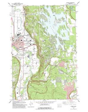
Sumner Topo Map Washington
To zoom in, hover over the map of Sumner
USGS Topo Quad 47122b2 - 1:24,000 scale
| Topo Map Name: | Sumner |
| USGS Topo Quad ID: | 47122b2 |
| Print Size: | ca. 21 1/4" wide x 27" high |
| Southeast Coordinates: | 47.125° N latitude / 122.125° W longitude |
| Map Center Coordinates: | 47.1875° N latitude / 122.1875° W longitude |
| U.S. State: | WA |
| Filename: | o47122b2.jpg |
| Download Map JPG Image: | Sumner topo map 1:24,000 scale |
| Map Type: | Topographic |
| Topo Series: | 7.5´ |
| Map Scale: | 1:24,000 |
| Source of Map Images: | United States Geological Survey (USGS) |
| Alternate Map Versions: |
Sumner WA 1956, updated 1957 Download PDF Buy paper map Sumner WA 1956, updated 1963 Download PDF Buy paper map Sumner WA 1956, updated 1969 Download PDF Buy paper map Sumner WA 1956, updated 1976 Download PDF Buy paper map Sumner WA 1993, updated 1993 Download PDF Buy paper map Sumner WA 2011 Download PDF Buy paper map Sumner WA 2014 Download PDF Buy paper map |
1:24,000 Topo Quads surrounding Sumner
> Back to 47122a1 at 1:100,000 scale
> Back to 47122a1 at 1:250,000 scale
> Back to U.S. Topo Maps home
Sumner topo map: Gazetteer
Sumner: Airports
Bryan Airport elevation 212m 695′Personal 500 Sales Company Heliport elevation 21m 68′
Sumner: Basins
Printz Basin elevation 166m 544′Sumner: Capes
Driftwood Point elevation 178m 583′Evergreen Point elevation 163m 534′
Hole in the Wall elevation 167m 547′
Maple Point elevation 176m 577′
Tacoma Point elevation 173m 567′
Sumner: Crossings
Wahl Road Interchange elevation 23m 75′Sumner: Dams
Lake Tapps Dike Number 10 elevation 167m 547′Lake Tapps Dike Number 11 elevation 167m 547′
Lake Tapps Dike Number 12 elevation 167m 547′
Lake Tapps Dike Number 13 elevation 166m 544′
Lake Tapps Dike Number 2A elevation 170m 557′
Lake Tapps Dike Number 2B elevation 168m 551′
Lake Tapps Dike Number Eight Dam elevation 166m 544′
Lake Tapps Dike Number Five Dam elevation 167m 547′
Lake Tapps Dike Number Four Dam elevation 155m 508′
Lake Tapps Dike Number Nine Dam elevation 166m 544′
Lake Tapps Dike Number One Dam elevation 168m 551′
Lake Tapps Dike Number Seven Dam elevation 166m 544′
Lake Tapps Dike Number Six Dam elevation 167m 547′
Printz Basin North Dike Dam elevation 166m 544′
Printz Basin South Dike Dam elevation 166m 544′
Sumner Pit Dam elevation 25m 82′
Trout Springs Hatchery Dam elevation 168m 551′
Sumner: Falls
Victor Falls elevation 112m 367′Sumner: Islands
Bankers Island elevation 173m 567′Deer Island elevation 174m 570′
Interlake Island elevation 174m 570′
Island A elevation 171m 561′
Island B elevation 172m 564′
Island Twentyone elevation 173m 567′
Scout Island elevation 174m 570′
Sumner: Lakes
Bonney Lake elevation 185m 606′Debra Jane Lake elevation 176m 577′
Hille Lake elevation 151m 495′
Leaky Lake elevation 169m 554′
Rhode Lake elevation 195m 639′
Sumner: Parks
Allan Yorke City Park elevation 166m 544′Historical Marker Connels Prairie Battle elevation 169m 554′
Lake Tapps County Park elevation 162m 531′
Loyalty Park elevation 23m 75′
Riverside County Park elevation 22m 72′
Seibenthaller Park elevation 21m 68′
Sumner: Populated Places
Alderton elevation 27m 88′Benroy elevation 22m 72′
Bonney Lake elevation 175m 574′
Cedar View elevation 190m 623′
Dieringer elevation 36m 118′
McMillin elevation 39m 127′
Ponderosa Estates elevation 194m 636′
Prairie Ridge elevation 209m 685′
Rhododendron Park elevation 193m 633′
Sumner elevation 23m 75′
Sumner: Reservoirs
Lake Tapps elevation 168m 551′Sumner Pit elevation 25m 82′
Trout Spring Hatchery elevation 168m 551′
Sumner: Springs
Salmon Springs elevation 104m 341′Sumner: Streams
Canyonfalls Creek elevation 29m 95′Carbon River elevation 34m 111′
Fennel Creek elevation 28m 91′
Salmon Creek elevation 13m 42′
Sumner: Tunnels
Penstock Tunnel elevation 159m 521′Sumner digital topo map on disk
Buy this Sumner topo map showing relief, roads, GPS coordinates and other geographical features, as a high-resolution digital map file on DVD:


