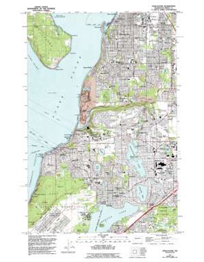
Steilacoom Topo Map Washington
To zoom in, hover over the map of Steilacoom
USGS Topo Quad 47122b5 - 1:24,000 scale
| Topo Map Name: | Steilacoom |
| USGS Topo Quad ID: | 47122b5 |
| Print Size: | ca. 21 1/4" wide x 27" high |
| Southeast Coordinates: | 47.125° N latitude / 122.5° W longitude |
| Map Center Coordinates: | 47.1875° N latitude / 122.5625° W longitude |
| U.S. State: | WA |
| Filename: | o47122b5.jpg |
| Download Map JPG Image: | Steilacoom topo map 1:24,000 scale |
| Map Type: | Topographic |
| Topo Series: | 7.5´ |
| Map Scale: | 1:24,000 |
| Source of Map Images: | United States Geological Survey (USGS) |
| Alternate Map Versions: |
Steilacoom WA 1948, updated 1955 Download PDF Buy paper map Steilacoom WA 1959, updated 1960 Download PDF Buy paper map Steilacoom WA 1959, updated 1970 Download PDF Buy paper map Steilacoom WA 1959, updated 1976 Download PDF Buy paper map Steilacoom WA 1959, updated 1981 Download PDF Buy paper map Steilacoom WA 1959, updated 1995 Download PDF Buy paper map Steilacoom WA 1997, updated 2003 Download PDF Buy paper map Steilacoom WA 2011 Download PDF Buy paper map Steilacoom WA 2014 Download PDF Buy paper map |
1:24,000 Topo Quads surrounding Steilacoom
> Back to 47122a1 at 1:100,000 scale
> Back to 47122a1 at 1:250,000 scale
> Back to U.S. Topo Maps home
Steilacoom topo map: Gazetteer
Steilacoom: Airports
American Lake Seaplane Base elevation 79m 259′Tacoma Airport elevation 109m 357′
Steilacoom: Bars
Toliva Shoal elevation 0m 0′Steilacoom: Bays
Chambers Bay elevation 0m 0′Steilacoom Waterway elevation 16m 52′
Steilacoom: Capes
Fox Point elevation 0m 0′Gibson Point elevation 30m 98′
Gordon Point elevation 1m 3′
Toy Point elevation 2m 6′
Steilacoom: Channels
Cormorant Passage elevation 0m 0′Steilacoom: Cliffs
Fourth Infantry Bluff elevation 25m 82′Thirtieth Infantry Bluff elevation 73m 239′
Steilacoom: Crossings
Interchange 123 elevation 82m 269′Interchange 124 elevation 86m 282′
Interchange 125 elevation 85m 278′
Steilacoom: Dams
Boise Cascade Aeration Lagoon Dam elevation 62m 203′Chambers Creek Reservoir Dam elevation 5m 16′
Steilacom Lake Dam elevation 76m 249′
Steilacoom: Islands
Days Island elevation 15m 49′Fox Island elevation 109m 357′
Silcox Island elevation 90m 295′
Steilacoom: Lakes
American Lake elevation 73m 239′Boyles Lake elevation 88m 288′
Carp Lake elevation 74m 242′
Carter Lake elevation 85m 278′
Emerson Lake elevation 82m 269′
Gravelly Lake elevation 80m 262′
Lake Louise elevation 84m 275′
Lost Lake elevation 88m 288′
Titlow Lagoon elevation 0m 0′
Waughop Lake elevation 74m 242′
Steilacoom: Parks
American Lake North County Park elevation 83m 272′American Lake South County Park elevation 81m 265′
Farrell Marsh Park elevation 78m 255′
Fort Steilacoom County Park elevation 74m 242′
South Tacoma State Game Farm elevation 54m 177′
South Tacoma State Game Refuge elevation 56m 183′
Sunnyside Beach Park elevation 8m 26′
Steilacoom: Populated Places
Clinton Park elevation 75m 246′Clover Park elevation 81m 265′
Custer elevation 77m 252′
Eastward elevation 5m 16′
Fircrest elevation 85m 278′
Hope elevation 18m 59′
Interlaken elevation 80m 262′
Ketron elevation 3m 9′
Lake City elevation 80m 262′
Lakewood elevation 80m 262′
Peach Acres elevation 74m 242′
Pioneer elevation 6m 19′
Ponders Corner elevation 86m 282′
Steilacoom elevation 20m 65′
Sunset Beach elevation 1m 3′
Titlow elevation 5m 16′
University Place elevation 63m 206′
Steilacoom: Post Offices
Lakewood Post Office elevation 80m 262′Steilacoom Post Office elevation 29m 95′
University Place Branch Post Office elevation 100m 328′
Steilacoom: Ranges
Porter Hills elevation 100m 328′Steilacoom: Reservoirs
Aeration Lagoon elevation 62m 203′Chambers Creek Reservoir elevation 5m 16′
Steilacoom Lake elevation 76m 249′
Steilacoom: Streams
Chambers Creek elevation 13m 42′Clover Creek elevation 66m 216′
Flett Creek elevation 37m 121′
Leach Creek elevation 51m 167′
Ponce De Leon Creek elevation 66m 216′
Steilacoom Creek elevation 61m 200′
Steilacoom: Summits
Cohn Hill elevation 113m 370′Kay Hill elevation 107m 351′
Lister Hill elevation 111m 364′
Ross Hill elevation 128m 419′
Steilacoom: Swamps
Crawford Marsh elevation 80m 262′Elliot Marsh elevation 76m 249′
Farrell Marsh elevation 78m 255′
Park Marsh elevation 75m 246′
Steilacoom: Woods
Curry Woods elevation 74m 242′Goddard Woods elevation 92m 301′
Porter Woods elevation 100m 328′
Steilacoom digital topo map on disk
Buy this Steilacoom topo map showing relief, roads, GPS coordinates and other geographical features, as a high-resolution digital map file on DVD:


