Mcneil Island Topo Map Washington
To zoom in, hover over the map of Mcneil Island
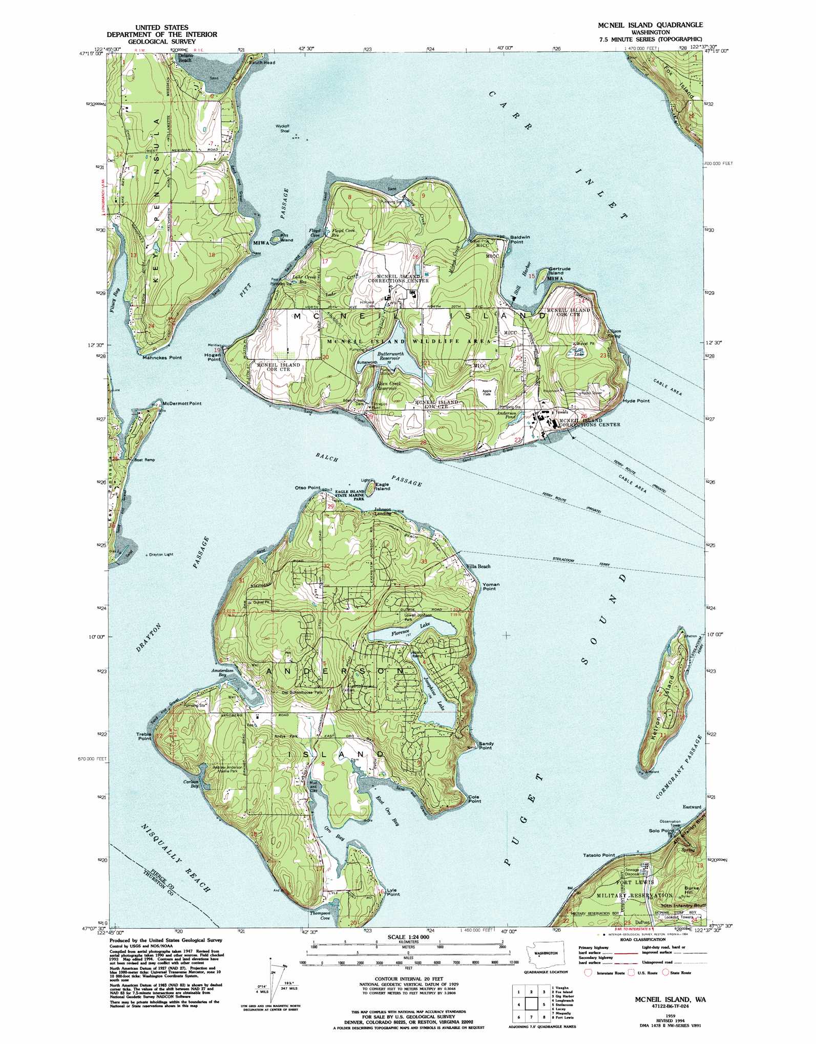
USGS Topo Quad 47122b6 - 1:24,000 scale
| Topo Map Name: | Mcneil Island |
| USGS Topo Quad ID: | 47122b6 |
| Print Size: | ca. 21 1/4" wide x 27" high |
| Southeast Coordinates: | 47.125° N latitude / 122.625° W longitude |
| Map Center Coordinates: | 47.1875° N latitude / 122.6875° W longitude |
| U.S. State: | WA |
| Filename: | o47122b6.jpg |
| Download Map JPG Image: | Mcneil Island topo map 1:24,000 scale |
| Map Type: | Topographic |
| Topo Series: | 7.5´ |
| Map Scale: | 1:24,000 |
| Source of Map Images: | United States Geological Survey (USGS) |
| Alternate Map Versions: |
Anderson Island WA 1948, updated 1955 Download PDF Buy paper map Mc Neil Island WA 1959, updated 1966 Download PDF Buy paper map Mc Neil Island WA 1959, updated 1969 Download PDF Buy paper map Mc Neil Island WA 1959, updated 1981 Download PDF Buy paper map Mc Neil Island WA 1959, updated 1991 Download PDF Buy paper map Mc Neil Island WA 1959, updated 1994 Download PDF Buy paper map Mc Neil Island WA 1997, updated 2003 Download PDF Buy paper map McNeil Island WA 2011 Download PDF Buy paper map McNeil Island WA 2014 Download PDF Buy paper map |
1:24,000 Topo Quads surrounding Mcneil Island
Lake Wooten |
Belfair |
Burley |
Olalla |
Vashon |
Mason Lake |
Vaughn |
Fox Island |
Gig Harbor |
Tacoma North |
Squaxin Island |
Longbranch |
Mcneil Island |
Steilacoom |
Tacoma South |
Olympia |
Lacey |
Nisqually |
Fort Lewis |
Spanaway |
Maytown |
East Olympia |
Tenalquot Prarie |
Mckenna |
Harts Lake |
> Back to 47122a1 at 1:100,000 scale
> Back to 47122a1 at 1:250,000 scale
> Back to U.S. Topo Maps home
Mcneil Island topo map: Gazetteer
Mcneil Island: Bars
Wycoff Shoal elevation 1m 3′Mcneil Island: Bays
Amsterdam Bay elevation 0m 0′Carlson Bay elevation 3m 9′
East Oro Bay elevation 0m 0′
Filucy Bay elevation 0m 0′
Floyd Cove elevation 0m 0′
Oro Bay elevation 0m 0′
Still Harbor elevation 1m 3′
Thompson Cove elevation 0m 0′
Mcneil Island: Capes
Baldwin Point elevation 0m 0′Cole Point elevation 2m 6′
Hogan Point elevation 1m 3′
Hyde Point elevation 3m 9′
Lyle Point elevation 2m 6′
Mahnckes Point elevation 4m 13′
McDermott Point elevation 6m 19′
Otso Point elevation 3m 9′
Samego Point elevation 6m 19′
Sandy Point elevation 1m 3′
Solo Point elevation 2m 6′
Tatsolo Point elevation 12m 39′
Tiye Point elevation 14m 45′
Treble Point elevation 18m 59′
Yoman Point elevation 1m 3′
Mcneil Island: Channels
Balch Passage elevation 0m 0′Drayton Passage elevation 0m 0′
Pitt Passage elevation 2m 6′
Mcneil Island: Dams
Anderson Pond Dam elevation 33m 108′Bradley Creek Dam elevation 7m 22′
Butterworth Dam elevation 12m 39′
Eden Creek Dam elevation 16m 52′
Floyd Cove Dam elevation 7m 22′
Kaelin Dam elevation 40m 131′
Luhr Creek Dam elevation 16m 52′
Milewa Creek Dam elevation 7m 22′
Prison Farm Sewage Lagoon Dam elevation 24m 78′
Mcneil Island: Islands
Anderson Island elevation 45m 147′Eagle Island elevation 15m 49′
Gertrude Island elevation 10m 32′
Ketron Island elevation 66m 216′
McNeil Island elevation 44m 144′
Pitt Island elevation 9m 29′
Mcneil Island: Lakes
Florence Lake elevation 61m 200′Josephine Lake elevation 61m 200′
Mcneil Island: Parks
Eagle Island State Marine Park elevation 15m 49′Mcneil Island: Populated Places
Bee elevation 25m 82′Gertrude elevation 4m 13′
Johnson Landing elevation 4m 13′
Meridian elevation 39m 127′
Yoman elevation 12m 39′
Mcneil Island: Reservoirs
Anderson Pond elevation 40m 131′Butterworth Reservoir elevation 22m 72′
Eden Creek Reservoir elevation 18m 59′
Floyd Cove Reservoir elevation 11m 36′
Luhr Creek Reservoir elevation 13m 42′
Prison Farm Sewage Lagoon elevation 24m 78′
Mcneil Island: Streams
Bradley Creek elevation 2m 6′Luhr Creek elevation 0m 0′
Mcneil Island: Summits
Burke Hill elevation 120m 393′Mcneil Island digital topo map on disk
Buy this Mcneil Island topo map showing relief, roads, GPS coordinates and other geographical features, as a high-resolution digital map file on DVD: