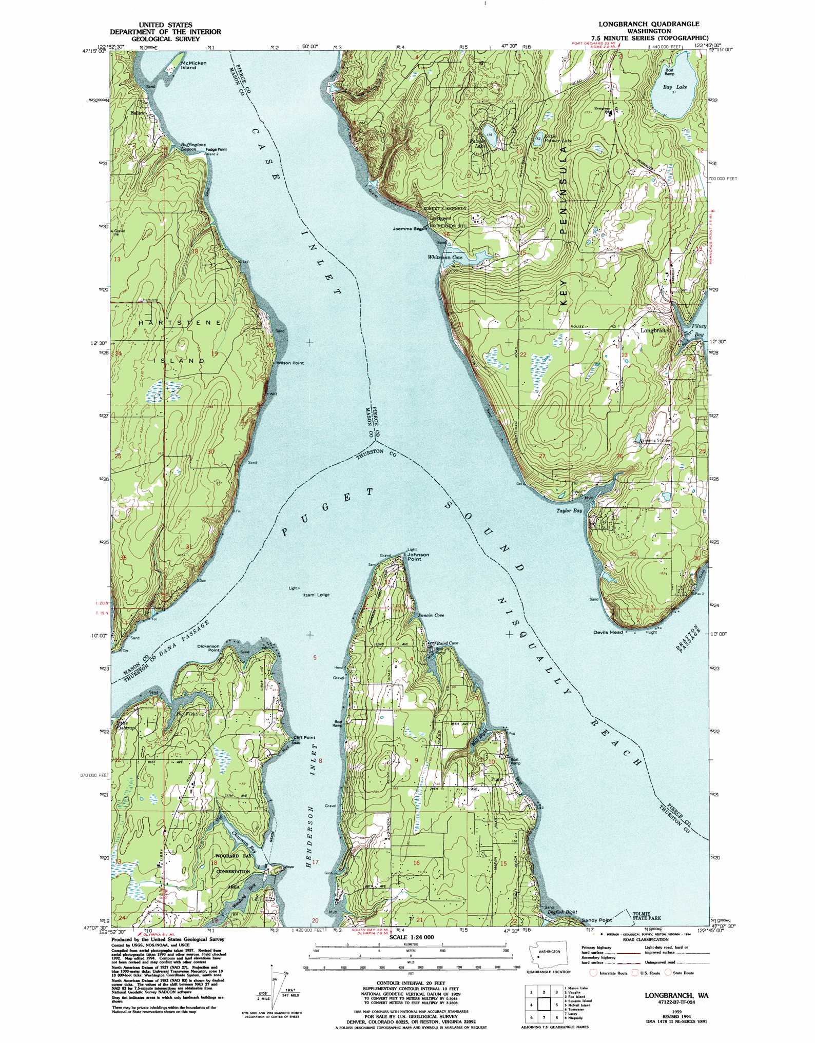
Longbranch Topo Map Washington
To zoom in, hover over the map of Longbranch
USGS Topo Quad 47122b7 - 1:24,000 scale
| Topo Map Name: | Longbranch |
| USGS Topo Quad ID: | 47122b7 |
| Print Size: | ca. 21 1/4" wide x 27" high |
| Southeast Coordinates: | 47.125° N latitude / 122.75° W longitude |
| Map Center Coordinates: | 47.1875° N latitude / 122.8125° W longitude |
| U.S. State: | WA |
| Filename: | o47122b7.jpg |
| Download Map JPG Image: | Longbranch topo map 1:24,000 scale |
| Map Type: | Topographic |
| Topo Series: | 7.5´ |
| Map Scale: | 1:24,000 |
| Source of Map Images: | United States Geological Survey (USGS) |
| Alternate Map Versions: |
Longbranch WA 1959, updated 1966 Download PDF Buy paper map Longbranch WA 1959, updated 1969 Download PDF Buy paper map Longbranch WA 1959, updated 1994 Download PDF Buy paper map Longbranch WA 1997, updated 2003 Download PDF Buy paper map Longbranch WA 2011 Download PDF Buy paper map Longbranch WA 2014 Download PDF Buy paper map |
1:24,000 Topo Quads surrounding Longbranch
Lilliwaup |
Lake Wooten |
Belfair |
Burley |
Olalla |
Union |
Mason Lake |
Vaughn |
Fox Island |
Gig Harbor |
Shelton |
Squaxin Island |
Longbranch |
Mcneil Island |
Steilacoom |
Summit Lake |
Olympia |
Lacey |
Nisqually |
Fort Lewis |
Little Rock |
Maytown |
East Olympia |
Tenalquot Prarie |
Mckenna |
> Back to 47122a1 at 1:100,000 scale
> Back to 47122a1 at 1:250,000 scale
> Back to U.S. Topo Maps home
Longbranch topo map: Gazetteer
Longbranch: Airports
Fishtrap Heliport elevation 31m 101′Longbranch: Bars
Itsami Ledge elevation 0m 0′Longbranch: Bays
Baird Cove elevation 0m 0′Big Fishtrap elevation 1m 3′
Buffingtons Lagoon elevation 0m 0′
Chapman Bay elevation 0m 0′
Dogfish Bight elevation 0m 0′
Henderson Inlet elevation 0m 0′
Mill Bight elevation 0m 0′
Nisqually Reach elevation 0m 0′
Poncin Cove elevation 1m 3′
Taylor Bay elevation 0m 0′
Whiteman Cove elevation 3m 9′
Woodard Bay elevation 0m 0′
Longbranch: Beaches
Joemma Beach elevation 9m 29′Longbranch: Capes
Cliff Point elevation 2m 6′Dickenson Point elevation 1m 3′
Fudge Point elevation 3m 9′
Johnson Point elevation 1m 3′
Wilson Point elevation 3m 9′
Longbranch: Channels
Dana Passage elevation 0m 0′Longbranch: Cliffs
Devils Head elevation 63m 206′Longbranch: Dams
Whiteman Cove Dam elevation 4m 13′Longbranch: Islands
McMicken Island elevation 1m 3′Longbranch: Lakes
Bay Lake elevation 10m 32′Little Palmer Lake elevation 17m 55′
Palmer Lake elevation 55m 180′
Longbranch: Populated Places
Ballow elevation 4m 13′Longbranch elevation 9m 29′
Puget elevation 18m 59′
Longbranch: Reservoirs
Whiteman Cove elevation 4m 13′Longbranch digital topo map on disk
Buy this Longbranch topo map showing relief, roads, GPS coordinates and other geographical features, as a high-resolution digital map file on DVD: