Mason Lake Topo Map Washington
To zoom in, hover over the map of Mason Lake
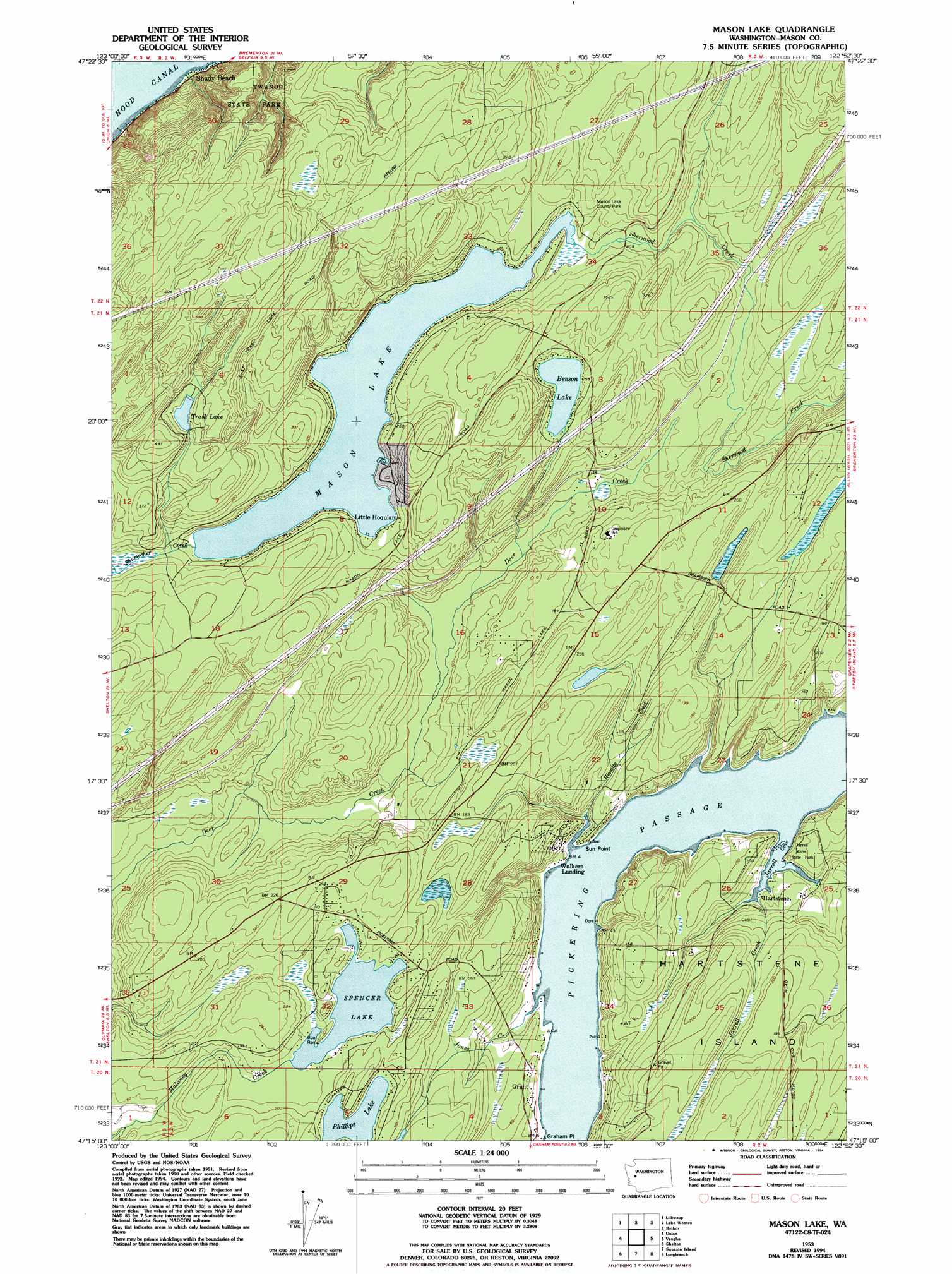
USGS Topo Quad 47122c8 - 1:24,000 scale
| Topo Map Name: | Mason Lake |
| USGS Topo Quad ID: | 47122c8 |
| Print Size: | ca. 21 1/4" wide x 27" high |
| Southeast Coordinates: | 47.25° N latitude / 122.875° W longitude |
| Map Center Coordinates: | 47.3125° N latitude / 122.9375° W longitude |
| U.S. State: | WA |
| Filename: | o47122c8.jpg |
| Download Map JPG Image: | Mason Lake topo map 1:24,000 scale |
| Map Type: | Topographic |
| Topo Series: | 7.5´ |
| Map Scale: | 1:24,000 |
| Source of Map Images: | United States Geological Survey (USGS) |
| Alternate Map Versions: |
Mason Lake WA 1953, updated 1955 Download PDF Buy paper map Mason Lake WA 1953, updated 1967 Download PDF Buy paper map Mason Lake WA 1953, updated 1969 Download PDF Buy paper map Mason Lake WA 1953, updated 1984 Download PDF Buy paper map Mason Lake WA 1953, updated 1994 Download PDF Buy paper map Mason Lake WA 1997, updated 2003 Download PDF Buy paper map Mason Lake WA 2011 Download PDF Buy paper map Mason Lake WA 2014 Download PDF Buy paper map |
1:24,000 Topo Quads surrounding Mason Lake
Mount Washington |
Eldon |
Holly |
Wildcat Lake |
Bremerton West |
Hoodsport |
Lilliwaup |
Lake Wooten |
Belfair |
Burley |
Skokomish Valley |
Union |
Mason Lake |
Vaughn |
Fox Island |
Shelton Valley |
Shelton |
Squaxin Island |
Longbranch |
Mcneil Island |
Kamilche Valley |
Summit Lake |
Olympia |
Lacey |
Nisqually |
> Back to 47122a1 at 1:100,000 scale
> Back to 47122a1 at 1:250,000 scale
> Back to U.S. Topo Maps home
Mason Lake topo map: Gazetteer
Mason Lake: Bays
Jarrell Cove elevation 1m 3′Mason Lake: Capes
Graham Point elevation 2m 6′Sun Point elevation 3m 9′
Mason Lake: Channels
Pickering Passage elevation 1m 3′Mason Lake: Dams
Buck Lake Dam elevation 55m 180′Courner Dam elevation 48m 157′
Mason Lake: Lakes
Benson Lake elevation 71m 232′Mason Lake elevation 60m 196′
Phillips Lake elevation 59m 193′
Spencer Lake elevation 53m 173′
Trask Lake elevation 109m 357′
Mason Lake: Parks
Jarrell Cove State Park elevation 20m 65′Twanoh State Park elevation 31m 101′
Mason Lake: Populated Places
Grant elevation 4m 13′Hartstene elevation 18m 59′
Little Hoquiam elevation 65m 213′
Walkers Landing elevation 6m 19′
Mason Lake: Streams
Hiawata Creek elevation 0m 0′Jarrell Creek elevation 2m 6′
Jones Creek elevation 0m 0′
Schumacher Creek elevation 61m 200′
Mason Lake digital topo map on disk
Buy this Mason Lake topo map showing relief, roads, GPS coordinates and other geographical features, as a high-resolution digital map file on DVD: