Vashon Topo Map Washington
To zoom in, hover over the map of Vashon
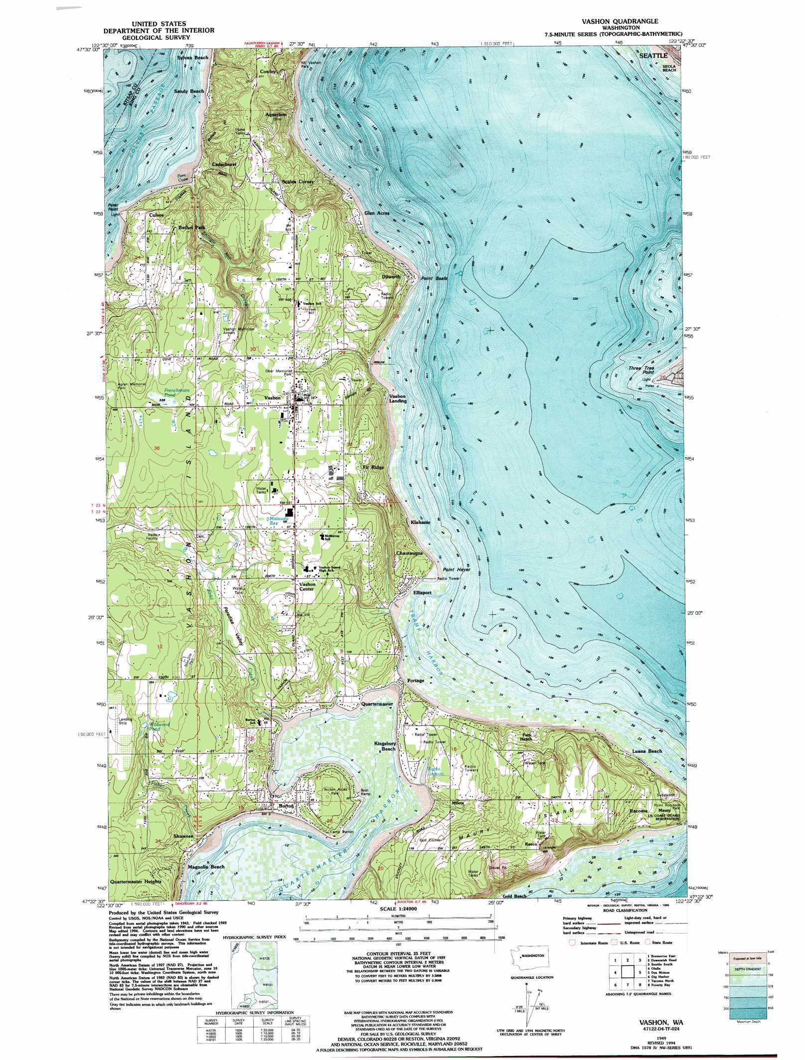
USGS Topo Quad 47122d4 - 1:24,000 scale
| Topo Map Name: | Vashon |
| USGS Topo Quad ID: | 47122d4 |
| Print Size: | ca. 21 1/4" wide x 27" high |
| Southeast Coordinates: | 47.375° N latitude / 122.375° W longitude |
| Map Center Coordinates: | 47.4375° N latitude / 122.4375° W longitude |
| U.S. State: | WA |
| Filename: | o47122d4.jpg |
| Download Map JPG Image: | Vashon topo map 1:24,000 scale |
| Map Type: | Topographic |
| Topo Series: | 7.5´ |
| Map Scale: | 1:24,000 |
| Source of Map Images: | United States Geological Survey (USGS) |
| Alternate Map Versions: |
Vashon WA 1949, updated 1956 Download PDF Buy paper map Vashon WA 1949, updated 1969 Download PDF Buy paper map Vashon WA 1949, updated 1975 Download PDF Buy paper map Vashon WA 1949, updated 1995 Download PDF Buy paper map Vashon WA 1997, updated 2003 Download PDF Buy paper map Vashon WA 2011 Download PDF Buy paper map Vashon WA 2014 Download PDF Buy paper map |
1:24,000 Topo Quads surrounding Vashon
Poulsbo |
Suquamish |
Seattle North |
||
Bremerton West |
Bremerton East |
Seattle South |
||
Burley |
Olalla |
Vashon |
Des Moines |
Renton |
Fox Island |
Gig Harbor |
Tacoma North |
Poverty Bay |
Auburn |
Mcneil Island |
Steilacoom |
Tacoma South |
Puyallup |
Sumner |
> Back to 47122a1 at 1:100,000 scale
> Back to 47122a1 at 1:250,000 scale
> Back to U.S. Topo Maps home
Vashon topo map: Gazetteer
Vashon: Airports
Quartermaster Harbor Seaplane Ramp elevation 0m 0′Therkelsen Heliport elevation 93m 305′
Vashon Municipal Airport elevation 95m 311′
Wax Orchards Airport elevation 114m 374′
Vashon: Bays
Fern Cove elevation 0m 0′Quartermaster Harbor elevation 1m 3′
Tramp Harbor elevation 0m 0′
Vashon: Capes
Peter Point elevation 3m 9′Point Beals elevation 8m 26′
Point Heyer elevation 1m 3′
Three Tree Point elevation 2m 6′
Vashon: Dams
Matsuda Reservoir Dam elevation 123m 403′Wildwood Pond Dam elevation 83m 272′
Vashon: Islands
Maury Island elevation 106m 347′Vashon Island elevation 91m 298′
Vashon: Lakes
Frenchmans Pond elevation 104m 341′Rabbs Lagoon elevation 2m 6′
Vashon: Parks
Burton Acres Park elevation 32m 104′Nike Site Park elevation 119m 390′
Northeast Vashon Park elevation 35m 114′
Ober Park elevation 95m 311′
Vashon: Populated Places
Bethel Park elevation 94m 308′Burton elevation 15m 49′
Cedarhurst elevation 21m 68′
Chautauqua elevation 19m 62′
Colvos elevation 43m 141′
Cowley elevation 108m 354′
Dilworth elevation 17m 55′
Ellisport elevation 8m 26′
Fern Heath elevation 79m 259′
Glen Acres elevation 6m 19′
Klahanie elevation 4m 13′
Magnolia Beach elevation 6m 19′
Maury elevation 38m 124′
Mileta elevation 27m 88′
Portage elevation 2m 6′
Raeco elevation 147m 482′
Shawnee elevation 7m 22′
Vashon elevation 116m 380′
Vermontville (historical) elevation 6m 19′
Vashon: Post Offices
Burton Post Office elevation 2m 6′Vashon: Reservoirs
Matsuda Reservoir elevation 123m 403′Wildwood Pond elevation 85m 278′
Vashon: Streams
Judd Creek elevation 0m 0′Shingle Mill Creek elevation 2m 6′
Vashon: Valleys
Paradise Valley elevation 6m 19′Vashon digital topo map on disk
Buy this Vashon topo map showing relief, roads, GPS coordinates and other geographical features, as a high-resolution digital map file on DVD: