Seattle South Topo Map Washington
To zoom in, hover over the map of Seattle South
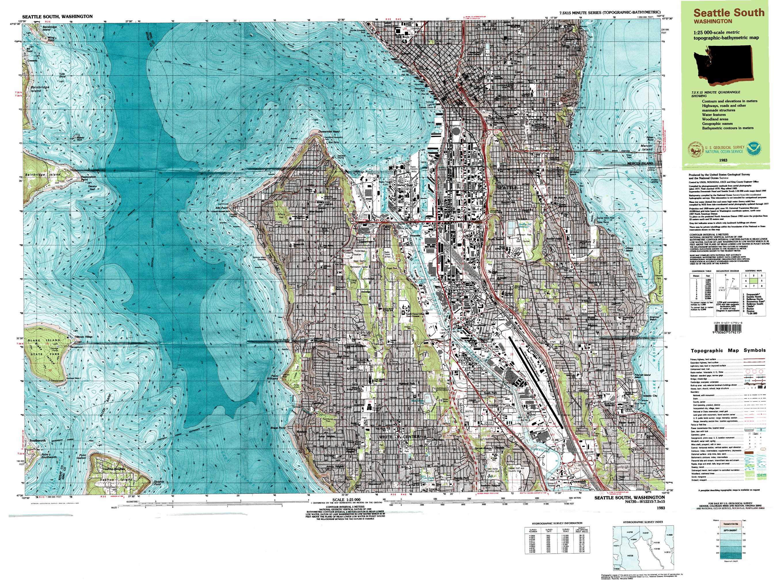
USGS Topo Quad 47122e3 - 1:25,000 scale
| Topo Map Name: | Seattle South |
| USGS Topo Quad ID: | 47122e3 |
| Print Size: | ca. 39" wide x 24" high |
| Southeast Coordinates: | 47.5° N latitude / 122.25° W longitude |
| Map Center Coordinates: | 47.5625° N latitude / 122.375° W longitude |
| U.S. State: | WA |
| Filename: | k47122e3.jpg |
| Download Map JPG Image: | Seattle South topo map 1:25,000 scale |
| Map Type: | Topographic |
| Topo Series: | 7.5´x15´ |
| Map Scale: | 1:25,000 |
| Source of Map Images: | United States Geological Survey (USGS) |
| Alternate Map Versions: |
Seattle South WA 1983, updated 1983 Download PDF Buy paper map Seattle South WA 1983, updated 1983 Download PDF Buy paper map Seattle South WA 1983, updated 1983 Download PDF Buy paper map |
1:24,000 Topo Quads surrounding Seattle South
Port Gamble |
Edmonds West |
Edmonds East |
Bothell |
Maltby |
Suquamish |
Seattle North |
Redmond |
||
Bremerton East |
Seattle South |
Issaquah |
||
Olalla |
Vashon |
Des Moines |
Renton |
Maple Valley |
Gig Harbor |
Tacoma North |
Poverty Bay |
Auburn |
Black Diamond |
> Back to 47122e1 at 1:100,000 scale
> Back to 47122a1 at 1:250,000 scale
> Back to U.S. Topo Maps home
Seattle South topo map: Gazetteer
Seattle South: Airports
1001 Fourth Avenue Plaza Heliport elevation 49m 160′Boeing Field-King County International Airport elevation 5m 16′
Boeing Plant 2 Heliport elevation 4m 13′
Broadcast House Helistop Heliport elevation 35m 114′
Edgewater Inn Heliport elevation 5m 16′
Harborview Medical Center Heliport elevation 99m 324′
KOMO-TV Heliport elevation 40m 131′
Plant 2 Heliport elevation 0m 0′
Seattle Private Number One Heliport elevation 24m 78′
Washington Building Heliport elevation 61m 200′
Seattle South: Bars
Allen Bank elevation 0m 0′Blakely Rock elevation 0m 0′
Decatur Reef elevation 0m 0′
Tee Shoal elevation 0m 0′
Tyee Shoal elevation 0m 0′
Seattle South: Bays
Andrews Bay elevation 5m 16′Elliott Bay elevation 0m 0′
Fauntleroy Cove elevation 0m 0′
Seattle South: Beaches
Alki Beach elevation 3m 9′Brighton Beach elevation 6m 19′
Mount Baker Beach elevation 9m 29′
Pritchett Island Beach elevation 7m 22′
Seattle South: Bridges
First Avenue South Bridge elevation 3m 9′Lacey V Murrow Bridge elevation 5m 16′
Seattle South: Capes
Alki Point elevation 6m 19′Bailey Peninsula elevation 38m 124′
Brace Point elevation 2m 6′
Dolphin Point elevation 1m 3′
Faben Point elevation 9m 29′
Point Southworth elevation 3m 9′
Point Vashon elevation 1m 3′
Point Williams elevation 4m 13′
Restoration Point elevation 1m 3′
Wing Point elevation 0m 0′
Seattle South: Channels
Duwamish East Waterway elevation 0m 0′Duwamish Waterway elevation 0m 0′
Duwamish West Waterway elevation 0m 0′
East Passage elevation 0m 0′
First Avenue Eigth Avenue Reach elevation 1m 3′
Forteenth Avenue Bridge Reach elevation 2m 6′
Georgetown Reach elevation 2m 6′
Harbor Island Reach elevation 4m 13′
South Park Reach elevation 2m 6′
Seattle South: Cliffs
Duwamish Head elevation 1m 3′Pigeon Point elevation 48m 157′
Seattle South: Crossings
Cloverdale Street Interchange elevation 11m 36′Duwamish Junction elevation 3m 9′
Fourteenth Avenue South Interchange elevation 11m 36′
Interchange 157 elevation 11m 36′
Interchange 158 elevation 10m 32′
Interchange 161A elevation 39m 127′
Interchange 161B elevation 21m 68′
Interchange 162 elevation 26m 85′
Interchange 163 elevation 25m 82′
Interchange 163A elevation 18m 59′
Interchange 163B elevation 17m 55′
Interchange 164 elevation 27m 88′
Interchange 165 elevation 57m 187′
Interchange 165A elevation 67m 219′
Interchange 165B elevation 50m 164′
Interchange 166 elevation 52m 170′
Interchange 169 elevation 105m 344′
Interchange 3 elevation 37m 121′
Interchange 6 elevation 14m 45′
Interchanges 164A and 164B elevation 27m 88′
Spokane Street Interchange elevation 27m 88′
Seattle South: Dams
Beacon Hill North Reservoir Dam elevation 100m 328′Beacon Hill South Reservoir Dam elevation 99m 324′
Lincoln Reservoir Dam elevation 98m 321′
Southwest Myrtle Street Reservoir Dam elevation 150m 492′
SW Genesee Street Dam elevation 11m 36′
West Seattle Reservoir Dam elevation 134m 439′
Seattle South: Harbors
Port of Seattle elevation 5m 16′Seattle South: Islands
Blake Island elevation 58m 190′Harbor Island elevation 2m 6′
Kellogg Island elevation 5m 16′
Ohlers Island elevation 6m 19′
Seattle South: Lakes
Hicks Lake elevation 115m 377′Lake Washington elevation 5m 16′
Seattle South: Parks
Atlantic City Park elevation 9m 29′Blake Island State Marine Park elevation 60m 196′
Colman Park elevation 45m 147′
Columbia Park elevation 70m 229′
Dearborn Park elevation 73m 239′
Denny Park elevation 26m 85′
Doctor Jose Rizal Park elevation 66m 216′
Fairmont Park elevation 85m 278′
Fauntleroy Park elevation 68m 223′
Freeway Park elevation 5m 16′
Frink Park elevation 42m 137′
Genesee Park elevation 19m 62′
Hamilton Viewpoint Park elevation 2m 6′
Jefferson Park elevation 106m 347′
Judkins Park elevation 60m 196′
Klondike Gold Rush National Historic Park elevation 8m 26′
Lake Washington Boulevard Park elevation 6m 19′
Lakeview Park elevation 46m 150′
Lakewood Park elevation 112m 367′
Leschi Park elevation 41m 134′
Lincoln Park elevation 38m 124′
Lincoln Park elevation 99m 324′
Madrona Park elevation 9m 29′
Me-Kwa-Mooks Park elevation 38m 124′
Mount Baker Park elevation 23m 75′
Myrtle Edwards Park elevation 6m 19′
Puget Park elevation 66m 216′
Qwest Field elevation 6m 19′
Riverview Playfield elevation 91m 298′
Safeco Field elevation 5m 16′
Sayres Memorial Park elevation 7m 22′
Schmitz Park elevation 43m 141′
Seola Park elevation 31m 101′
Sicks Stadium elevation 16m 52′
Viretta Park elevation 24m 78′
Waterfront Park elevation 2m 6′
West Seattle Recreation Center elevation 41m 134′
Westcrest Park elevation 115m 377′
Seattle South: Pillars
Blakely Rock elevation 0m 0′Seattle South: Populated Places
Alki elevation 9m 29′Arbor Heights elevation 115m 377′
Arroyo Heights elevation 104m 341′
Beacon Hill elevation 88m 288′
Belltown elevation 31m 101′
Biloxi elevation 41m 134′
Brighton elevation 44m 144′
Capitol Hill elevation 105m 344′
Columbia elevation 17m 55′
Columbia City elevation 34m 111′
Delridge elevation 58m 190′
Denny Regrade elevation 29m 95′
Dunlap elevation 14m 45′
Duwamish elevation 4m 13′
Endolyne elevation 48m 157′
Fauntleroy elevation 11m 36′
Georgetown elevation 4m 13′
Glendale elevation 55m 180′
High Point elevation 151m 495′
Highland Park elevation 135m 442′
Hillman City (historical) elevation 9m 29′
Holly Park elevation 72m 236′
Lakewood elevation 24m 78′
Lowman Beach Park elevation 11m 36′
Madrona elevation 87m 285′
Mann elevation 82m 269′
Mount Baker elevation 41m 134′
Rainier Beach elevation 51m 167′
Rainier Valley elevation 43m 141′
Roxbury Heights elevation 102m 334′
Seattle elevation 54m 177′
Seward Park elevation 20m 65′
South Park elevation 7m 22′
South Seattle elevation 87m 285′
Tamill elevation 36m 118′
Van Asselt elevation 6m 19′
Vashon Heights elevation 49m 160′
West Seattle elevation 117m 383′
White Center elevation 116m 380′
Yesler Terrace elevation 59m 193′
Youngstown elevation 24m 78′
Seattle South: Post Offices
Broadway Branch Post Office elevation 101m 331′Columbia Center Branch Post Office elevation 50m 164′
Columbia Post Office elevation 22m 72′
East Union Post Office elevation 96m 314′
Federal Station Post Office elevation 10m 32′
Georgetown Post Office elevation 4m 13′
Mid-Town Seattle Post Office elevation 40m 131′
Pioneer Square Branch Post Office elevation 7m 22′
Queen Anne Post Office elevation 39m 127′
Terminal Finance Station Seattle Post Office elevation 7m 22′
West Seattle Post Office elevation 108m 354′
Westwood Post Office elevation 85m 278′
Seattle South: Reservoirs
Beacon Hill North Reservoir elevation 100m 328′Beacon Hill Reservoir elevation 95m 311′
Lincoln Reservoir elevation 98m 321′
Southwest Myrtle Street Reservoir elevation 150m 492′
West Seattle Reservoir elevation 133m 436′
Seattle South: Ridges
Harrison Ridge elevation 73m 239′Mount Baker Ridge elevation 83m 272′
Seattle South: Streams
Duwamish River elevation 4m 13′Seattle South: Summits
Denny Hill elevation 53m 173′Seattle South: Tunnels
Battery Street Subway elevation 38m 124′Mount Baker Ridge Tunnel elevation 41m 134′
North Portal elevation 28m 91′
South Portal elevation 4m 13′
Seattle South: Valleys
Fairmount Gulch elevation 7m 22′Seattle South digital topo map on disk
Buy this Seattle South topo map showing relief, roads, GPS coordinates and other geographical features, as a high-resolution digital map file on DVD: