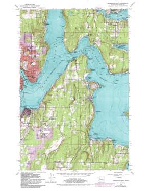
Bremerton East Topo Map Washington
To zoom in, hover over the map of Bremerton East
USGS Topo Quad 47122e5 - 1:24,000 scale
| Topo Map Name: | Bremerton East |
| USGS Topo Quad ID: | 47122e5 |
| Print Size: | ca. 21 1/4" wide x 27" high |
| Southeast Coordinates: | 47.5° N latitude / 122.5° W longitude |
| Map Center Coordinates: | 47.5625° N latitude / 122.5625° W longitude |
| U.S. State: | WA |
| Filename: | o47122e5.jpg |
| Download Map JPG Image: | Bremerton East topo map 1:24,000 scale |
| Map Type: | Topographic |
| Topo Series: | 7.5´ |
| Map Scale: | 1:24,000 |
| Source of Map Images: | United States Geological Survey (USGS) |
| Alternate Map Versions: |
Bremerton East WA 1953, updated 1955 Download PDF Buy paper map Bremerton East WA 1953, updated 1969 Download PDF Buy paper map Bremerton East WA 1953, updated 1976 Download PDF Buy paper map Bremerton East WA 1953, updated 1981 Download PDF Buy paper map Bremerton East WA 2011 Download PDF Buy paper map Bremerton East WA 2014 Download PDF Buy paper map |
1:24,000 Topo Quads surrounding Bremerton East
> Back to 47122e1 at 1:100,000 scale
> Back to 47122a1 at 1:250,000 scale
> Back to U.S. Topo Maps home
Bremerton East topo map: Gazetteer
Bremerton East: Airports
Manchester Laboratory Heliport elevation 4m 13′Bremerton East: Areas
Tatugh elevation 2m 6′Bremerton East: Bars
Hornbecks Split elevation 1m 3′Bremerton East: Bays
Blakely Harbor elevation 0m 0′Clam Bay elevation 0m 0′
Eagle Harbor elevation 0m 0′
Little Clam Bay elevation 0m 0′
Yukon Harbor elevation 0m 0′
Bremerton East: Bridges
Manette Bridge elevation 0m 0′Bremerton East: Capes
Beans Point elevation 2m 6′Bill Point elevation -1m -4′
Middle Point elevation 4m 13′
Mitchell Point elevation 1m 3′
Orchard Point elevation 9m 29′
Point Glover elevation 4m 13′
Point Herron elevation 3m 9′
Point Turner elevation 16m 52′
Point White elevation 7m 22′
Bremerton East: Channels
Rich Passage elevation 0m 0′Bremerton East: Dams
David Lake Dam elevation 59m 193′James Dam elevation 58m 190′
Bremerton East: Lakes
Gazzam Lake elevation 95m 311′Bremerton East: Parks
Bataan Park elevation 129m 423′East Park elevation 58m 190′
Fort Ward State Park elevation 16m 52′
Illahee State Park elevation 82m 269′
Manchester State Park elevation 6m 19′
Sheridan Park elevation 45m 147′
Bremerton East: Populated Places
Annapolis elevation 16m 52′Colby elevation 10m 32′
Colchester elevation 26m 85′
Conifer Park elevation 115m 377′
Creosote elevation 33m 108′
Crystal Springs elevation 7m 22′
Eagledale elevation 37m 121′
East Port Orchard elevation 92m 301′
Enetai elevation 30m 98′
Fort Ward elevation 74m 242′
Harper elevation 5m 16′
Illahee elevation 11m 36′
Lynwood Center elevation 7m 22′
Manchester elevation 11m 36′
Manette elevation 34m 111′
Orchard Heights elevation 116m 380′
Parkwood elevation 81m 265′
Point White elevation 12m 39′
Port Blakely elevation 13m 42′
Retsil elevation 29m 95′
South Beach elevation 8m 26′
South Colby elevation 15m 49′
Southworth elevation 23m 75′
Waterman elevation 2m 6′
Waterman Point elevation 2m 6′
Wautauga Beach elevation 4m 13′
West Blakely elevation 13m 42′
Westwood elevation 10m 32′
Bremerton East: Post Offices
Bainbridge Island Post Office elevation 20m 65′Manette Post Office elevation 18m 59′
Southworth Post Office elevation 22m 72′
Bremerton East: Reservoirs
Lake David elevation 59m 193′Bremerton East: Streams
Beaver Creek elevation 0m 0′Curley Creek elevation 3m 9′
Enetai Creek elevation 0m 0′
Bremerton East: Summits
Orchard Rocks elevation 0m 0′Bremerton East digital topo map on disk
Buy this Bremerton East topo map showing relief, roads, GPS coordinates and other geographical features, as a high-resolution digital map file on DVD:


