Holly Topo Map Washington
To zoom in, hover over the map of Holly
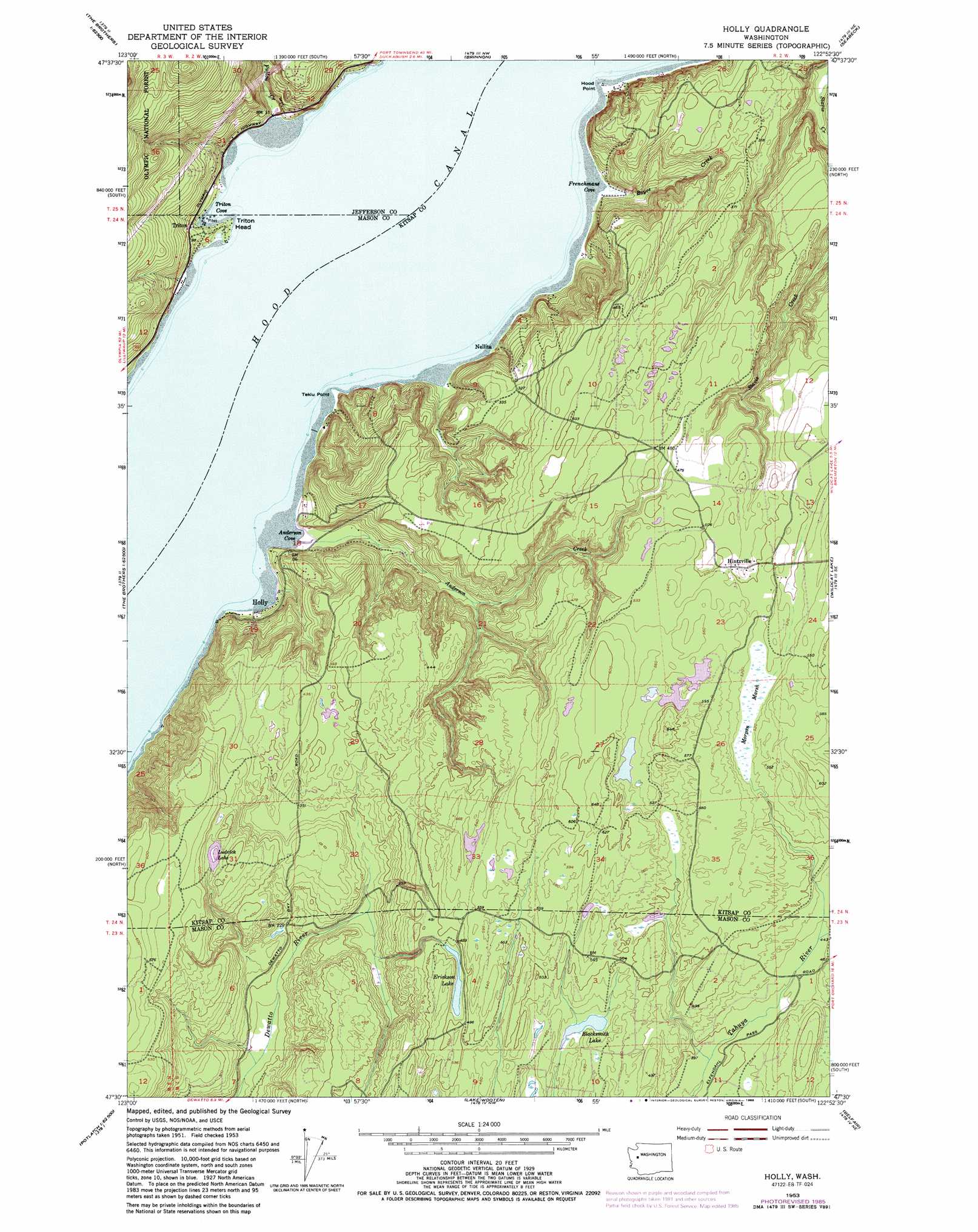
USGS Topo Quad 47122e8 - 1:24,000 scale
| Topo Map Name: | Holly |
| USGS Topo Quad ID: | 47122e8 |
| Print Size: | ca. 21 1/4" wide x 27" high |
| Southeast Coordinates: | 47.5° N latitude / 122.875° W longitude |
| Map Center Coordinates: | 47.5625° N latitude / 122.9375° W longitude |
| U.S. State: | WA |
| Filename: | o47122e8.jpg |
| Download Map JPG Image: | Holly topo map 1:24,000 scale |
| Map Type: | Topographic |
| Topo Series: | 7.5´ |
| Map Scale: | 1:24,000 |
| Source of Map Images: | United States Geological Survey (USGS) |
| Alternate Map Versions: |
Holly WA 1953, updated 1955 Download PDF Buy paper map Holly WA 1953, updated 1967 Download PDF Buy paper map Holly WA 1953, updated 1969 Download PDF Buy paper map Holly WA 1953, updated 1977 Download PDF Buy paper map Holly WA 1953, updated 1981 Download PDF Buy paper map Holly WA 1953, updated 1986 Download PDF Buy paper map Holly WA 2011 Download PDF Buy paper map Holly WA 2014 Download PDF Buy paper map |
| FStopo: | US Forest Service topo Holly is available: Download FStopo PDF Download FStopo TIF |
1:24,000 Topo Quads surrounding Holly
Mount Deception |
Mount Townsend |
Mount Walker |
Quilcene |
Lofall |
The Brothers |
Mount Jupiter |
Brinnon |
Seabeck |
Poulsbo |
Mount Washington |
Eldon |
Holly |
Wildcat Lake |
Bremerton West |
Hoodsport |
Lilliwaup |
Lake Wooten |
Belfair |
Burley |
Skokomish Valley |
Union |
Mason Lake |
Vaughn |
Fox Island |
> Back to 47122e1 at 1:100,000 scale
> Back to 47122a1 at 1:250,000 scale
> Back to U.S. Topo Maps home
Holly topo map: Gazetteer
Holly: Bays
Anderson Cove elevation 1m 3′Frenchmans Cove elevation 1m 3′
Hood Canal elevation 0m 0′
Triton Cove elevation 1m 3′
Holly: Capes
Hood Point elevation 2m 6′Tekiu Point elevation 0m 0′
Holly: Lakes
Blacksmith Lake elevation 131m 429′Erickson Lake elevation 142m 465′
Hintzville Beaver Ponds elevation 171m 561′
Ludvick Lake elevation 139m 456′
Holly: Populated Places
Hintzville elevation 146m 479′Holly elevation 9m 29′
Triton elevation 21m 68′
Holly: Streams
Anderson Creek elevation 1m 3′Boyce Creek elevation 3m 9′
Fulton Creek elevation 2m 6′
Holly: Summits
Triton Head elevation 10m 32′Holly: Swamps
Morgan Marsh elevation 156m 511′Holly digital topo map on disk
Buy this Holly topo map showing relief, roads, GPS coordinates and other geographical features, as a high-resolution digital map file on DVD: