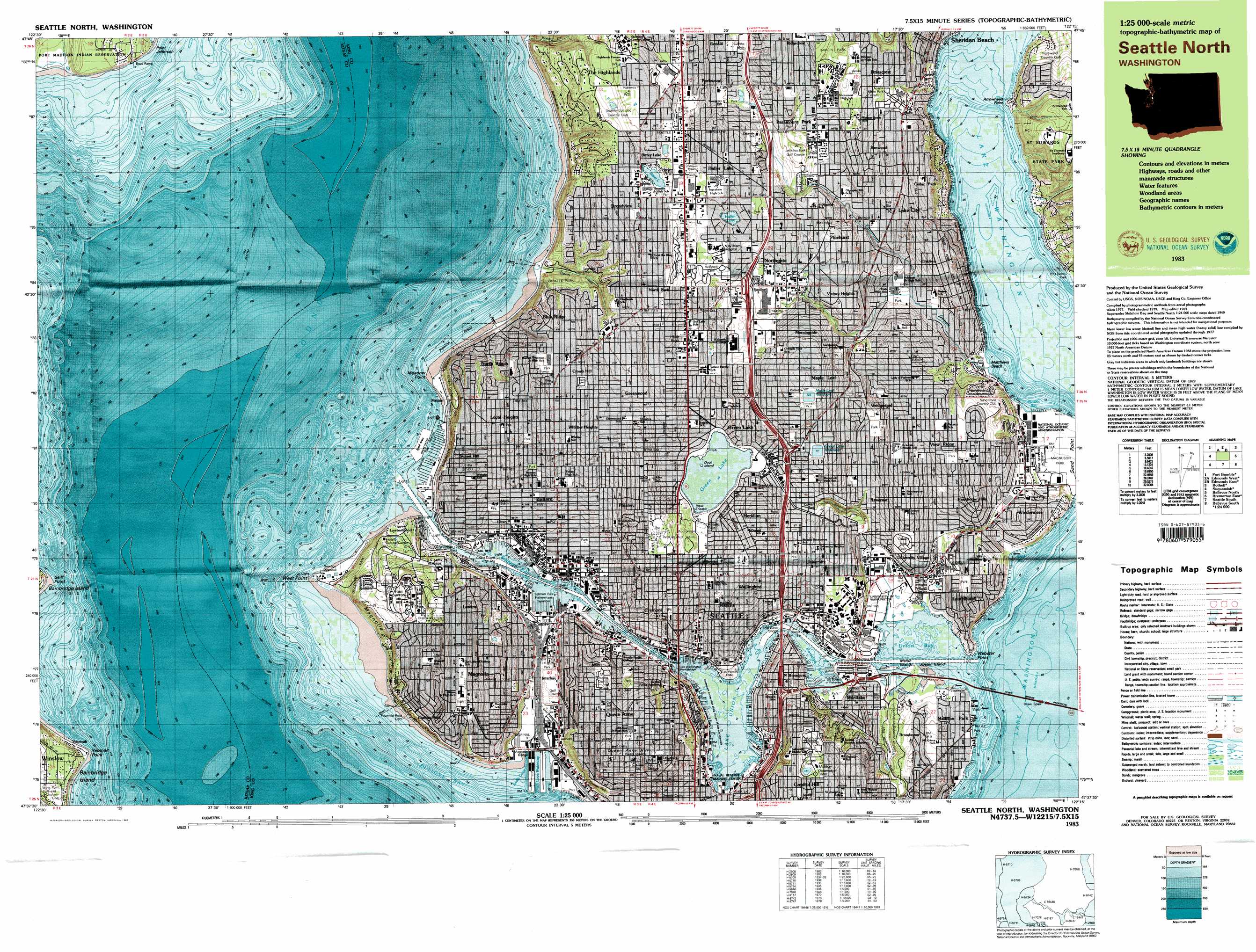
Seattle North Topo Map Washington
To zoom in, hover over the map of Seattle North
USGS Topo Quad 47122f3 - 1:25,000 scale
| Topo Map Name: | Seattle North |
| USGS Topo Quad ID: | 47122f3 |
| Print Size: | ca. 39" wide x 24" high |
| Southeast Coordinates: | 47.625° N latitude / 122.25° W longitude |
| Map Center Coordinates: | 47.6875° N latitude / 122.375° W longitude |
| U.S. State: | WA |
| Filename: | k47122f3.jpg |
| Download Map JPG Image: | Seattle North topo map 1:25,000 scale |
| Map Type: | Topographic |
| Topo Series: | 7.5´x15´ |
| Map Scale: | 1:25,000 |
| Source of Map Images: | United States Geological Survey (USGS) |
| Alternate Map Versions: |
Seattle North WA 1983, updated 1983 Download PDF Buy paper map Seattle North WA 1983, updated 1983 Download PDF Buy paper map |
1:24,000 Topo Quads surrounding Seattle North
Hansville |
Maxwelton |
Mukilteo |
Everett |
Snohomish |
Port Gamble |
Edmonds West |
Edmonds East |
Bothell |
Maltby |
Suquamish |
Seattle North |
Redmond |
||
Bremerton East |
Seattle South |
Issaquah |
||
Olalla |
Vashon |
Des Moines |
Renton |
Maple Valley |
> Back to 47122e1 at 1:100,000 scale
> Back to 47122a1 at 1:250,000 scale
> Back to U.S. Topo Maps home
Seattle North topo map: Gazetteer
Seattle North: Airports
Lake Union Air Service Seaplane Base elevation 9m 29′Lake Union Chrysler Air Seaplane Base elevation 10m 32′
Lake Union Heliport elevation 5m 16′
Seattle North: Bays
Pontiac Bay elevation 5m 16′Portage Bay elevation 5m 16′
Salmon Bay elevation 5m 16′
Shilshole Bay elevation 0m 0′
Smith Cove elevation 2m 6′
Smith Cove Waterway elevation 5m 16′
Union Bay elevation 5m 16′
Wolf Bay elevation 5m 16′
Seattle North: Beaches
Matthews Beach elevation 6m 19′Seattle North: Bridges
Ballard Bridge elevation 6m 19′Evergreen Point Bridge elevation 5m 16′
Fremont Bridge elevation 5m 16′
George Washington Memorial Bridge elevation 5m 16′
Magnolia Bridge elevation 2m 6′
Montlake Bridge elevation 6m 19′
University Bridge elevation 5m 16′
Seattle North: Canals
Lake Washington Ship Canal elevation 5m 16′Seattle North: Capes
Arrowhead Point elevation 6m 19′Holmes Point elevation 7m 22′
Meadow Point elevation 2m 6′
Point Jefferson elevation 5m 16′
Sand Point elevation 12m 39′
Skiff Point elevation 2m 6′
Webster Point elevation 16m 52′
West Point elevation 2m 6′
Yeomalt Point elevation 2m 6′
Seattle North: Channels
Montlake Cut elevation 6m 19′Portage Bay Reach elevation 5m 16′
Shilshole Bay Entrance Range elevation 55m 180′
Union Bay Reach elevation 5m 16′
Seattle North: Cliffs
Magnolia Bluff elevation 16m 52′Seattle North: Crossings
Interchange 167 elevation 37m 121′Interchange 172 elevation 89m 291′
Interchange 173 elevation 91m 298′
Interchange 174 elevation 115m 377′
Interchange 175 elevation 95m 311′
Interchange 175B elevation 113m 370′
Interchanges 168A and 168B elevation 44m 144′
Interchanges 170 and 171 elevation 65m 213′
Seattle North: Dams
Bitter Lake Reservoir Dam elevation 142m 465′Green Lake Reservoir Dam elevation 99m 324′
Hiram M Chittenden Locks elevation 7m 22′
Hiram M Chittenden Locks and Dam elevation 2m 6′
Magnolia Manor Reservoir Dam elevation 101m 331′
Maple Leaf Reservoir Dam elevation 129m 423′
Volunteer Park Reservoir Dam elevation 124m 406′
Seattle North: Harbors
Shilshole Bay Marina elevation -2m -7′Seattle North: Islands
Duck Island elevation 57m 187′Foster Island elevation 6m 19′
Marsh Island elevation 7m 22′
Seattle North: Lakes
Bitter Lake elevation 134m 439′Green Lake elevation 50m 164′
Haller Lake elevation 114m 374′
Lake Union elevation 5m 16′
Seattle North: Parks
Aurora Stadium elevation 137m 449′Ballard Playground elevation 29m 95′
Bayview Playground elevation 63m 206′
Carkeek Park elevation 52m 170′
Cowen Park elevation 51m 167′
Dahl Park elevation 74m 242′
Denny Yard elevation 56m 183′
Discovery Park elevation 85m 278′
Drumheller Fountain elevation 38m 124′
Froula Park elevation 98m 321′
Gas Works Park elevation 9m 29′
Gilman Playground elevation 16m 52′
Golden Gardens Park elevation 39m 127′
Hamlin Park elevation 122m 400′
Interlaken Park elevation 49m 160′
Intramural Sports Field Number 3 elevation 9m 29′
Kinnear Park elevation 57m 187′
Laurelhurst Park elevation 62m 203′
Leif Erikson Statue elevation 2m 6′
Loyal Heights Playground elevation 79m 259′
Magnolia Park elevation 35m 114′
Magnolia Playground elevation 50m 164′
Magnuson Park elevation 10m 32′
Matthews Beach Park elevation 16m 52′
Meadow Brook Park elevation 22m 72′
Montlake Playground elevation 8m 26′
North Acres Park elevation 124m 406′
Pinehurst Playground elevation 96m 314′
Ravenna Park elevation 29m 95′
Rogers Park elevation 52m 170′
Saint Edwards State Park elevation 105m 344′
Salmon Bay Park elevation 62m 203′
The Glads Sculpture Garden elevation 15m 49′
Union Bay Natural Area elevation 8m 26′
University of Washington Baseball Stadium elevation 8m 26′
University of Washington Intramural Sports Field Number 1 elevation 10m 32′
University of Washington Medicinal Herb Garden elevation 30m 98′
University of Washington Quad elevation 50m 164′
University of Washington Soccer Field elevation 7m 22′
University of Washington Stadium elevation 15m 49′
University of Washington Tennis Courts elevation 11m 36′
University of Washington Womens Soccer Field elevation 11m 36′
View Ridge Park elevation 94m 308′
Volunteer Park elevation 134m 439′
Washington Park elevation 18m 59′
Washington Park Arboretum elevation 27m 88′
Windermere Park elevation 7m 22′
Woodland Park elevation 85m 278′
Seattle North: Populated Places
Adams elevation 21m 68′Ballard elevation 48m 157′
Bitter Lake elevation 144m 472′
Blue Ridge elevation 107m 351′
Briarcliff elevation 100m 328′
Briarcrest elevation 104m 341′
Briercrest elevation 81m 265′
Broadmoor elevation 48m 157′
Broadview elevation 132m 433′
Broadway elevation 14m 45′
Bryant elevation 42m 137′
Carlton Park elevation 84m 275′
Cedar Park elevation 102m 334′
Chelsea elevation 55m 180′
Crown Hill elevation 108m 354′
Edgewater (historical) elevation 47m 154′
Edgewater Park elevation 8m 26′
Evergreen elevation 138m 452′
Foy elevation 147m 482′
Fremont elevation 56m 183′
Green Lake elevation 79m 259′
Greenwood elevation 95m 311′
Haller Lake elevation 131m 429′
Hawthorne Hills elevation 84m 275′
Interbay elevation 65m 213′
Kenwood elevation 71m 232′
Lake City elevation 74m 242′
Latona (historical) elevation 9m 29′
Laurelhurst elevation 57m 187′
Lavilla elevation 17m 55′
Lawton elevation 85m 278′
Lawtonwood elevation 19m 62′
Loyal Heights elevation 92m 301′
Madison Park elevation 14m 45′
Magnolia Bluff elevation 61m 200′
Manitou elevation 13m 42′
Maple Leaf elevation 124m 406′
Matthews Beach elevation 48m 157′
Meadowbrook elevation 19m 62′
Meridian elevation 85m 278′
Metum elevation 3m 9′
Montlake elevation 32m 104′
Morningside elevation 106m 347′
North Beach elevation 58m 190′
North Broadway elevation 47m 154′
North College Park elevation 86m 282′
North Park elevation 120m 393′
Northgate elevation 105m 344′
Olympic Hills elevation 75m 246′
Paramount Park elevation 116m 380′
Parkwood elevation 116m 380′
Phinney Ridge elevation 61m 200′
Pinehurst elevation 106m 347′
Pontiac elevation 87m 285′
Portage Bay elevation 21m 68′
Queen Anne elevation 120m 393′
Ravenna elevation 77m 252′
Ridgecrest elevation 119m 390′
Ronald elevation 135m 442′
Roosevelt elevation 90m 295′
Ross (historical) elevation 32m 104′
Sand Point elevation 12m 39′
Sheridan Beach elevation 59m 193′
Spring Beach elevation 68m 223′
Stevens elevation 109m 357′
Sunset Hill elevation 53m 173′
The Highlands elevation 137m 449′
University elevation 81m 265′
University District elevation 61m 200′
University Village elevation 74m 242′
Victory Heights elevation 87m 285′
View Ridge elevation 107m 351′
Wallingford elevation 37m 121′
Wedgwood elevation 106m 347′
West Woodland elevation 23m 75′
Whittier Heights elevation 105m 344′
Windermere elevation 67m 219′
Yeomalt elevation 12m 39′
Seattle North: Post Offices
Ballard Post Office elevation 30m 98′Bitter Lake Post Office elevation 145m 475′
Greenwood Post Office elevation 87m 285′
Lake City Post Office elevation 61m 200′
Magnolia Post Office elevation 47m 154′
Northgate Post Office elevation 87m 285′
University Post Office elevation 50m 164′
Wallingford Post Office elevation 68m 223′
Wedgewood Post Office elevation 91m 298′
Seattle North: Reservoirs
Bitter Lake Reservoir elevation 142m 465′Green Lake Reservoir elevation 98m 321′
Magnolia Manor Reservoir elevation 101m 331′
Maple Leaf Reservoir elevation 129m 423′
Volunteer Park Reservoir elevation 124m 406′
Seattle North: Ridges
Phinney Ridge elevation 104m 341′Seattle North: Streams
Boeing Creek elevation 5m 16′McAleer Creek elevation 6m 19′
Meridian Creek elevation 96m 314′
Mohlendorph Creek elevation 31m 101′
Pipers Creek elevation 4m 13′
Ravenna Creek elevation 9m 29′
Scheuerman Creek elevation 32m 104′
Thornton Creek elevation 6m 19′
University Slough elevation 5m 16′
Venema Creek elevation 13m 42′
Seattle North: Summits
Queen Anne Hill elevation 119m 390′Seattle North: Trails
Burke Gilman Trail elevation 10m 32′Seattle North digital topo map on disk
Buy this Seattle North topo map showing relief, roads, GPS coordinates and other geographical features, as a high-resolution digital map file on DVD: