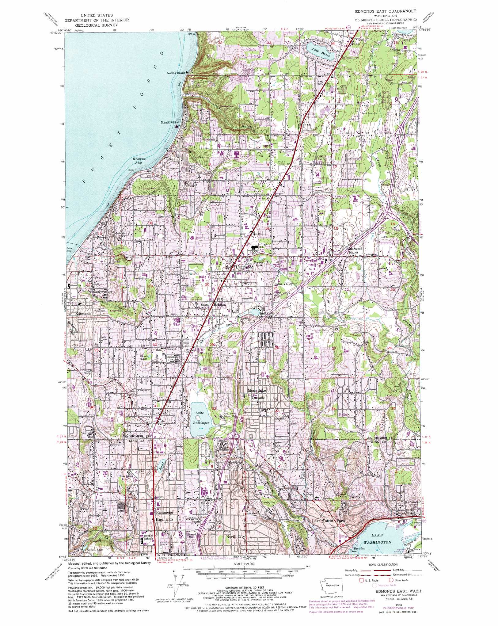
Edmonds East Topo Map Washington
To zoom in, hover over the map of Edmonds East
USGS Topo Quad 47122g3 - 1:24,000 scale
| Topo Map Name: | Edmonds East |
| USGS Topo Quad ID: | 47122g3 |
| Print Size: | ca. 21 1/4" wide x 27" high |
| Southeast Coordinates: | 47.75° N latitude / 122.25° W longitude |
| Map Center Coordinates: | 47.8125° N latitude / 122.3125° W longitude |
| U.S. State: | WA |
| Filename: | o47122g3.jpg |
| Download Map JPG Image: | Edmonds East topo map 1:24,000 scale |
| Map Type: | Topographic |
| Topo Series: | 7.5´ |
| Map Scale: | 1:24,000 |
| Source of Map Images: | United States Geological Survey (USGS) |
| Alternate Map Versions: |
Edmonds East WA 1953, updated 1955 Download PDF Buy paper map Edmonds East WA 1953, updated 1969 Download PDF Buy paper map Edmonds East WA 1953, updated 1976 Download PDF Buy paper map Edmonds East WA 1953, updated 1981 Download PDF Buy paper map Edmonds East WA 1953, updated 1981 Download PDF Buy paper map Edmonds East WA 2011 Download PDF Buy paper map Edmonds East WA 2014 Download PDF Buy paper map |
1:24,000 Topo Quads surrounding Edmonds East
Freeland |
Langley |
Tulalip |
Marysville |
Lake Stevens |
Hansville |
Maxwelton |
Mukilteo |
Everett |
Snohomish |
Port Gamble |
Edmonds West |
Edmonds East |
Bothell |
Maltby |
Suquamish |
Seattle North |
Redmond |
||
Bremerton East |
Seattle South |
Issaquah |
> Back to 47122e1 at 1:100,000 scale
> Back to 47122a1 at 1:250,000 scale
> Back to U.S. Topo Maps home
Edmonds East topo map: Gazetteer
Edmonds East: Airports
Kenmore Air Harbor Inc Seaplane Base elevation 5m 16′Stevens Memorial Hospital Heliport elevation 114m 374′
Edmonds East: Bays
Browns Bay elevation 0m 0′Edmonds East: Crossings
Interchange 176 elevation 113m 370′Interchange 177 elevation 126m 413′
Interchange 178 elevation 126m 413′
Interchange 179 elevation 140m 459′
Interchange 181B elevation 130m 426′
Interchange 182 elevation 110m 360′
Interchange 183 elevation 146m 479′
Interchange181A elevation 104m 341′
Edmonds East: Dams
Ballinger Lake Outlet Dam elevation 89m 291′Hidden Lake Dam elevation 65m 213′
Lake Forest Park Reservoir Dam elevation 166m 544′
Edmonds East: Harbors
Kenmore Air Harbor elevation 5m 16′Edmonds East: Lakes
Chase Lake elevation 121m 396′Echo Lake elevation 120m 393′
Hall Lake elevation 103m 337′
Lake Serene elevation 164m 538′
Scriber Lake elevation 101m 331′
Stickney Lake elevation 135m 442′
Edmonds East: Parks
Kings Garden elevation 131m 429′Maplewood Park elevation 118m 387′
Pine Ridge Park elevation 101m 331′
Seaview Park elevation 125m 410′
Sierra Park elevation 125m 410′
Yost Park elevation 89m 291′
Edmonds East: Populated Places
Alderwood Manor elevation 129m 423′Beverly Acres elevation 129m 423′
Brier elevation 125m 410′
Cedar Valley elevation 105m 344′
Echo Lake elevation 122m 400′
Esperance elevation 115m 377′
Firdale elevation 121m 396′
Lake Forest Park elevation 23m 75′
Lynnwood elevation 120m 393′
Meadowdale elevation 28m 91′
Mountlake Terrace elevation 140m 459′
North City elevation 143m 469′
North Lynnwood elevation 147m 482′
Perrinville elevation 117m 383′
Richmond Highlands elevation 145m 475′
Seattle Heights elevation 125m 410′
Serene elevation 166m 544′
Shoreline elevation 147m 482′
Edmonds East: Post Offices
Alderwood Manor Post Office elevation 129m 423′Kenmore Post Office elevation 17m 55′
Lynnwood Post Office elevation 127m 416′
Mountlake Terrace Post Office elevation 141m 462′
North City Post Office elevation 141m 462′
Edmonds East: Reservoirs
Hidden Lake elevation 62m 203′Lake Ballinger elevation 89m 291′
Lake Forest Reservoir elevation 166m 544′
Edmonds East: Streams
Hall Creek elevation 86m 282′Lyon Creek elevation 15m 49′
Sammamish River elevation 5m 16′
Shell Creek elevation 0m 0′
Squawk Slough elevation 5m 16′
Edmonds East: Swamps
Ronald Bog elevation 110m 360′Edmonds East: Valleys
Lunds Gulch elevation 0m 0′Edmonds East digital topo map on disk
Buy this Edmonds East topo map showing relief, roads, GPS coordinates and other geographical features, as a high-resolution digital map file on DVD: