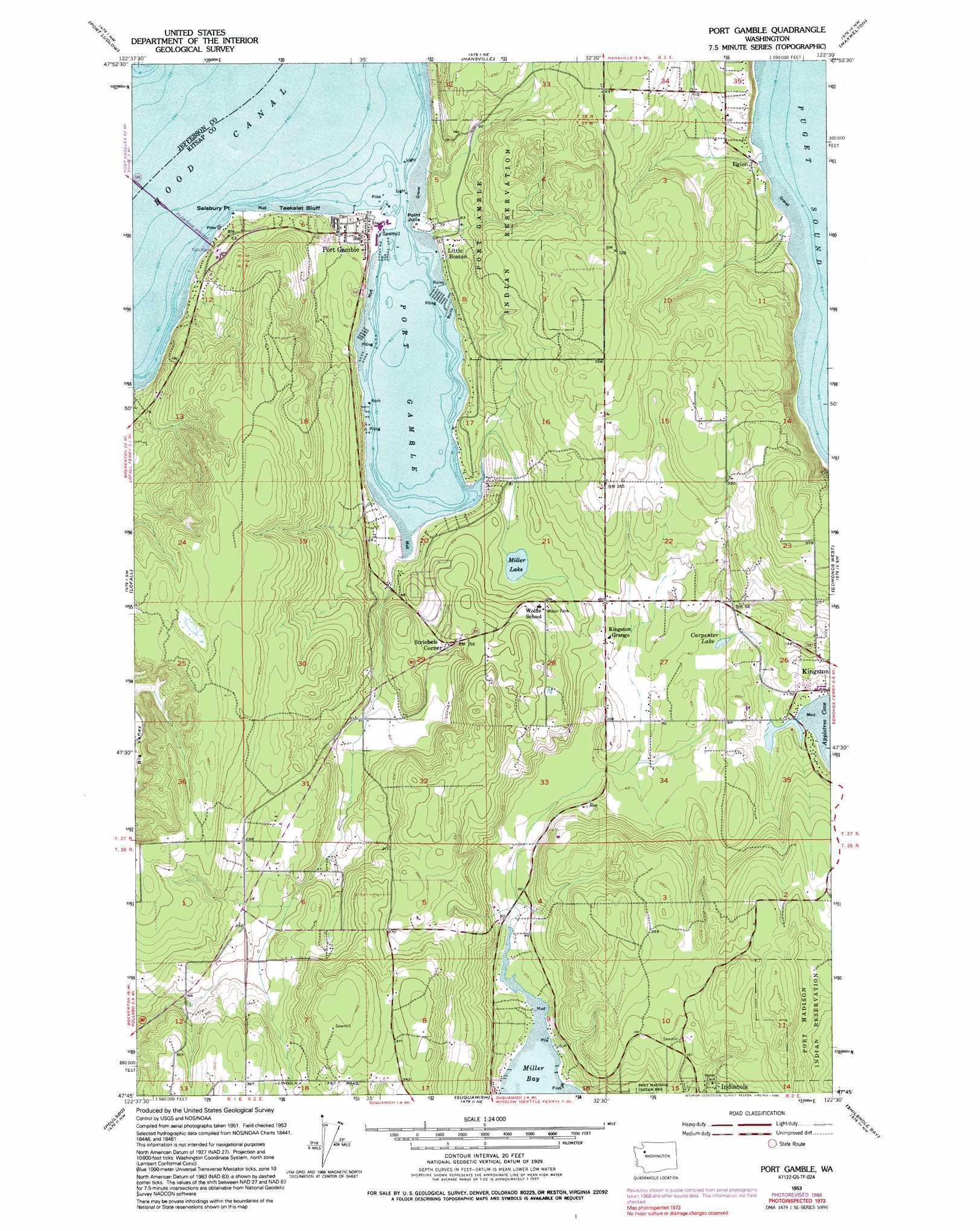
Port Gamble Topo Map Washington
To zoom in, hover over the map of Port Gamble
USGS Topo Quad 47122g5 - 1:24,000 scale
| Topo Map Name: | Port Gamble |
| USGS Topo Quad ID: | 47122g5 |
| Print Size: | ca. 21 1/4" wide x 27" high |
| Southeast Coordinates: | 47.75° N latitude / 122.5° W longitude |
| Map Center Coordinates: | 47.8125° N latitude / 122.5625° W longitude |
| U.S. State: | WA |
| Filename: | o47122g5.jpg |
| Download Map JPG Image: | Port Gamble topo map 1:24,000 scale |
| Map Type: | Topographic |
| Topo Series: | 7.5´ |
| Map Scale: | 1:24,000 |
| Source of Map Images: | United States Geological Survey (USGS) |
| Alternate Map Versions: |
Port Gamble WA 1953, updated 1955 Download PDF Buy paper map Port Gamble WA 1953, updated 1968 Download PDF Buy paper map Port Gamble WA 1953, updated 1969 Download PDF Buy paper map Port Gamble WA 1953, updated 1979 Download PDF Buy paper map Port Gamble WA 1953, updated 1995 Download PDF Buy paper map Port Gamble WA 1997, updated 2003 Download PDF Buy paper map Port Gamble WA 2011 Download PDF Buy paper map Port Gamble WA 2014 Download PDF Buy paper map |
1:24,000 Topo Quads surrounding Port Gamble
Port Townsend South |
Nordland |
Freeland |
Langley |
Tulalip |
Center |
Port Ludlow |
Hansville |
Maxwelton |
Mukilteo |
Quilcene |
Lofall |
Port Gamble |
Edmonds West |
Edmonds East |
Seabeck |
Poulsbo |
Suquamish |
Seattle North |
|
Wildcat Lake |
Bremerton West |
Bremerton East |
Seattle South |
> Back to 47122e1 at 1:100,000 scale
> Back to 47122a1 at 1:250,000 scale
> Back to U.S. Topo Maps home
Port Gamble topo map: Gazetteer
Port Gamble: Bays
Miller Bay elevation 0m 0′Port Gamble elevation 1m 3′
Port Gamble: Bridges
Hood Canal Bridge elevation 0m 0′Port Gamble: Capes
Point Julia elevation 2m 6′Salsbury Point elevation 3m 9′
Port Gamble: Cliffs
Teekalet Bluff elevation 16m 52′Port Gamble: Dams
Courtenay Dam elevation 23m 75′Port Gamble: Harbors
Port Gamble elevation 1m 3′Port Gamble: Lakes
Carpenter Lake elevation 12m 39′Miller Lake elevation 16m 52′
Port Gamble: Populated Places
Eglon elevation 4m 13′Little Boston elevation 20m 65′
Port Gamble elevation 18m 59′
Rose Point elevation 4m 13′
Striebels Corner elevation 55m 180′
Port Gamble: Streams
Carpenter Creek elevation 2m 6′Crabapple Creek elevation 3m 9′
Fukuzawa Creek elevation 10m 32′
Kingfisher Creek elevation 3m 9′
Kingston Creek elevation 0m 0′
Silver Creek elevation 20m 65′
Port Gamble digital topo map on disk
Buy this Port Gamble topo map showing relief, roads, GPS coordinates and other geographical features, as a high-resolution digital map file on DVD: