Aberdeen Gardens Topo Map Washington
To zoom in, hover over the map of Aberdeen Gardens
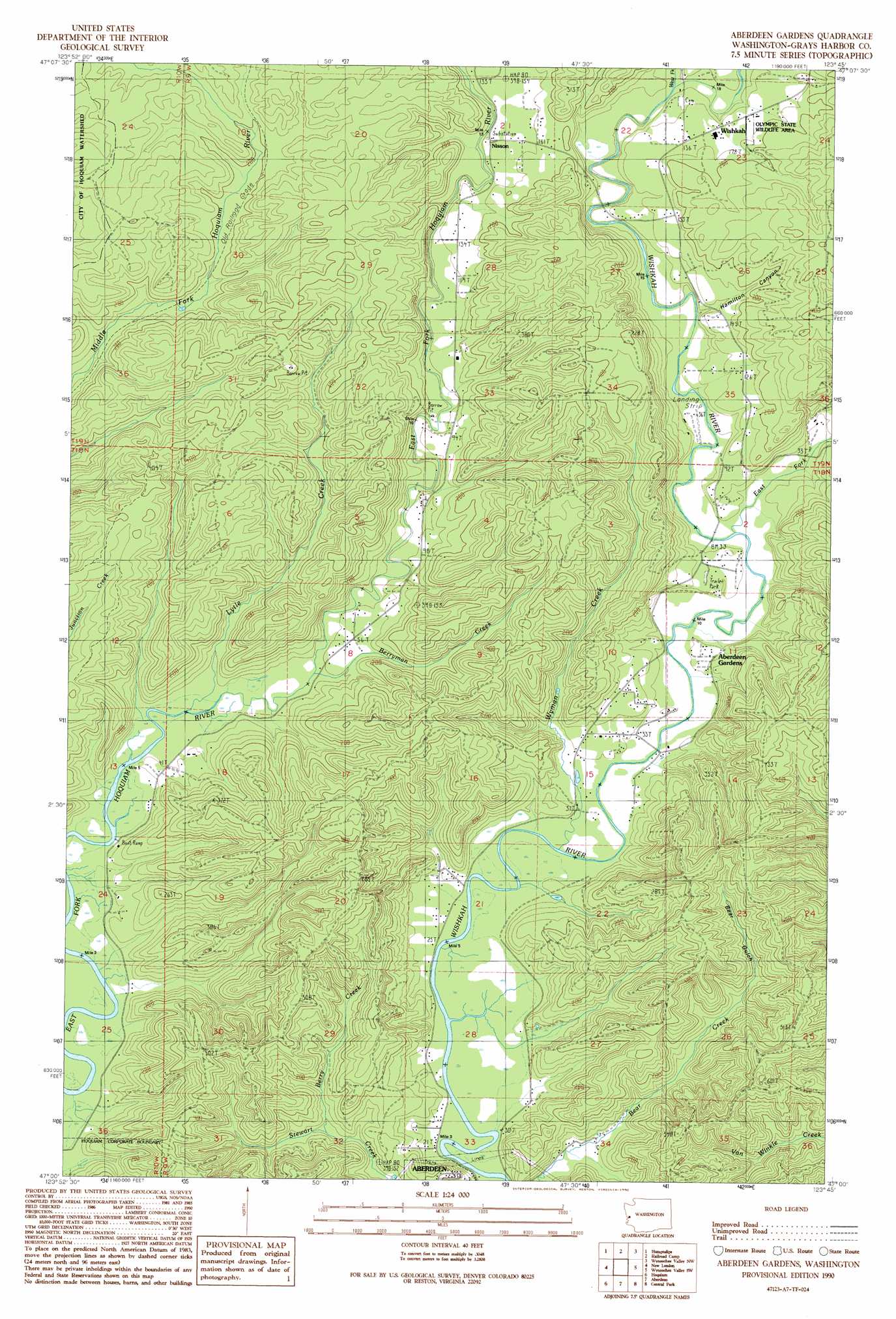
USGS Topo Quad 47123a7 - 1:24,000 scale
| Topo Map Name: | Aberdeen Gardens |
| USGS Topo Quad ID: | 47123a7 |
| Print Size: | ca. 21 1/4" wide x 27" high |
| Southeast Coordinates: | 47° N latitude / 123.75° W longitude |
| Map Center Coordinates: | 47.0625° N latitude / 123.8125° W longitude |
| U.S. State: | WA |
| Filename: | o47123a7.jpg |
| Download Map JPG Image: | Aberdeen Gardens topo map 1:24,000 scale |
| Map Type: | Topographic |
| Topo Series: | 7.5´ |
| Map Scale: | 1:24,000 |
| Source of Map Images: | United States Geological Survey (USGS) |
| Alternate Map Versions: |
Aberdeen Gardens WA 1990, updated 1990 Download PDF Buy paper map Aberdeen Gardens WA 2011 Download PDF Buy paper map Aberdeen Gardens WA 2014 Download PDF Buy paper map |
1:24,000 Topo Quads surrounding Aberdeen Gardens
Macafee Hill |
Stevens Creek |
Burnt Hill |
Larsen Creek |
Grisdale |
Carlisle |
Humptulips |
Railroad Camp |
Wynoochee Valley Nw |
Wynoochee Valley Ne |
Copalis Crossing |
New London |
Aberdeen Gardens |
Wynoochee Valley Sw |
Prices Peak |
Westport |
Hoquiam |
Aberdeen |
Central Park |
Montesano |
Grayland |
Western |
Aberdeen Se |
Elkhorn Creek |
Brooklyn |
> Back to 47123a1 at 1:100,000 scale
> Back to 47122a1 at 1:250,000 scale
> Back to U.S. Topo Maps home
Aberdeen Gardens topo map: Gazetteer
Aberdeen Gardens: Airports
Wishkah River Ranch Airport elevation 14m 45′Aberdeen Gardens: Populated Places
Aberdeen Gardens elevation 14m 45′Nisson elevation 38m 124′
Wishkah elevation 44m 144′
Aberdeen Gardens: Streams
Berry Creek elevation 13m 42′Berryman Creek elevation 9m 29′
East Fork Wishkah River elevation 14m 45′
Lytle Creek elevation 9m 29′
West Fork Wishkah River elevation 23m 75′
Wyman Creek elevation 12m 39′
Aberdeen Gardens: Valleys
Bear Gulch elevation 38m 124′Hamilton Canyon elevation 21m 68′
Aberdeen Gardens digital topo map on disk
Buy this Aberdeen Gardens topo map showing relief, roads, GPS coordinates and other geographical features, as a high-resolution digital map file on DVD: