Quinault Lake East Topo Map Washington
To zoom in, hover over the map of Quinault Lake East
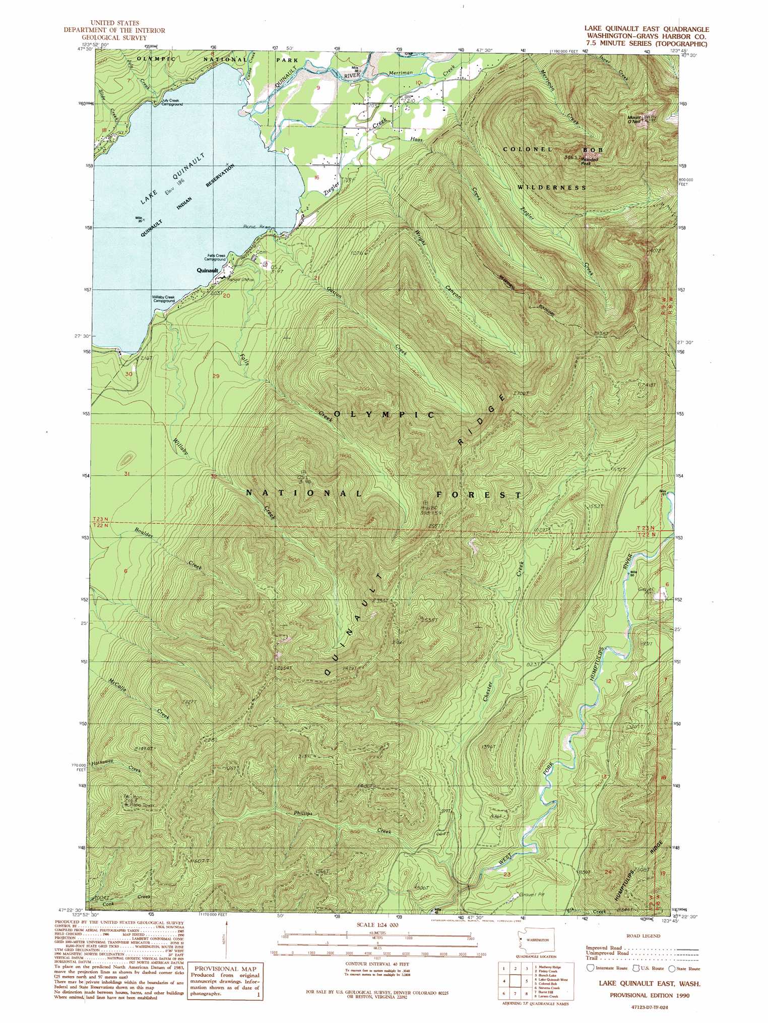
USGS Topo Quad 47123d7 - 1:24,000 scale
| Topo Map Name: | Quinault Lake East |
| USGS Topo Quad ID: | 47123d7 |
| Print Size: | ca. 21 1/4" wide x 27" high |
| Southeast Coordinates: | 47.375° N latitude / 123.75° W longitude |
| Map Center Coordinates: | 47.4375° N latitude / 123.8125° W longitude |
| U.S. State: | WA |
| Filename: | o47123d7.jpg |
| Download Map JPG Image: | Quinault Lake East topo map 1:24,000 scale |
| Map Type: | Topographic |
| Topo Series: | 7.5´ |
| Map Scale: | 1:24,000 |
| Source of Map Images: | United States Geological Survey (USGS) |
| Alternate Map Versions: |
Lake Quinault East WA 1990, updated 1990 Download PDF Buy paper map Lake Quinault East WA 2011 Download PDF Buy paper map Lake Quinault East WA 2014 Download PDF Buy paper map |
| FStopo: | US Forest Service topo Lake Quinault East is available: Download FStopo PDF Download FStopo TIF |
1:24,000 Topo Quads surrounding Quinault Lake East
Stequaleho Creek |
Kloochman Rock |
Bob Creek |
Kimta Peak |
Mount Christie |
Salmon River East |
Matheny Ridge |
Finley Creek |
Bunch Lake |
Mount Hoquiam |
Thimble Mountain |
Quinault Lake West |
Quinault Lake East |
Colonel Bob |
Wynoochee Lake |
Macafee Hill |
Stevens Creek |
Burnt Hill |
Larsen Creek |
Grisdale |
Carlisle |
Humptulips |
Railroad Camp |
Wynoochee Valley Nw |
Wynoochee Valley Ne |
> Back to 47123a1 at 1:100,000 scale
> Back to 47122a1 at 1:250,000 scale
> Back to U.S. Topo Maps home
Quinault Lake East topo map: Gazetteer
Quinault Lake East: Areas
Quinault Research Natural Area elevation 136m 446′Quinault Lake East: Forests
Quinault Ranger District (historical) elevation 551m 1807′Quinault Lake East: Lakes
Lake Quinault elevation 58m 190′Quinault Lake East: Parks
Quinault Recreation Area elevation 125m 410′Quinault Lake East: Populated Places
Norwood elevation 66m 216′Quinault elevation 93m 305′
Quinault Lake East: Ridges
Quinault Ridge elevation 735m 2411′Quinault Lake East: Streams
Canoe Creek elevation 59m 193′Chester Creek elevation 123m 403′
Falls Creek elevation 65m 213′
Finley Creek elevation 61m 200′
Gatton Creek elevation 58m 190′
Haas Creek elevation 67m 219′
July Creek elevation 58m 190′
McCormick Creek elevation 58m 190′
Merriman Creek elevation 62m 203′
Phillips Creek elevation 165m 541′
Rampage Creek elevation 192m 629′
Slide Creek elevation 58m 190′
Willaby Creek elevation 78m 255′
Ziegler Creek elevation 60m 196′
Quinault Lake East: Summits
Bell Mountain elevation 833m 2732′Mount O'Neil elevation 1276m 4186′
Wooded Peak elevation 1174m 3851′
Quinault Lake East: Valleys
Wright Canyon elevation 119m 390′Quinault Lake East digital topo map on disk
Buy this Quinault Lake East topo map showing relief, roads, GPS coordinates and other geographical features, as a high-resolution digital map file on DVD: