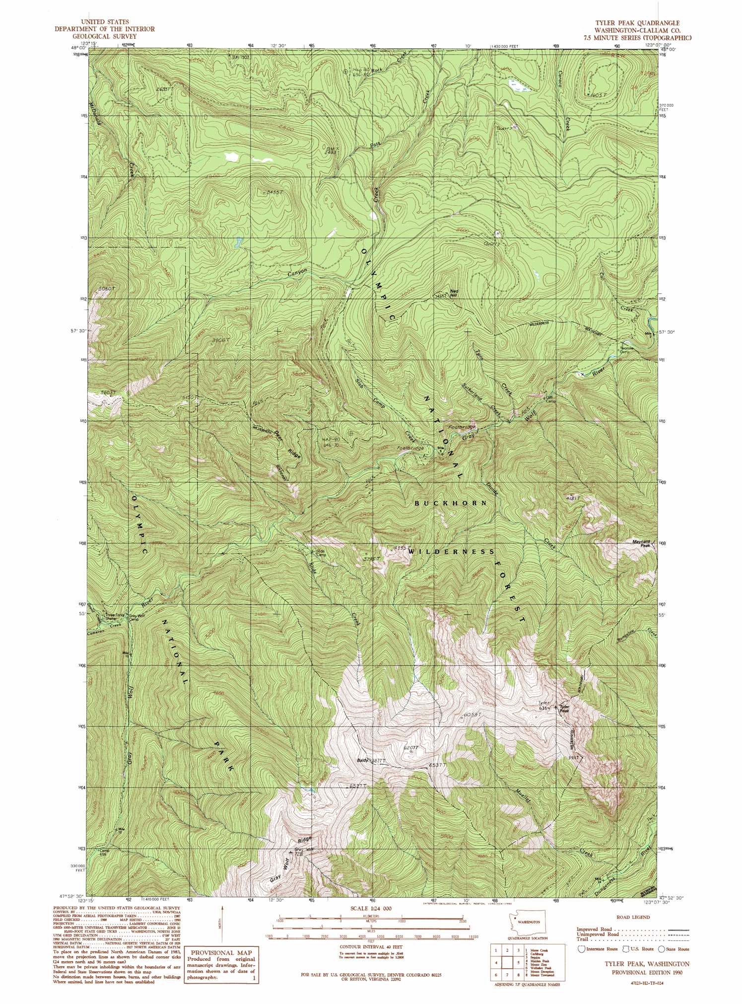
Tyler Peak Topo Map Washington
To zoom in, hover over the map of Tyler Peak
USGS Topo Quad 47123h2 - 1:24,000 scale
| Topo Map Name: | Tyler Peak |
| USGS Topo Quad ID: | 47123h2 |
| Print Size: | ca. 21 1/4" wide x 27" high |
| Southeast Coordinates: | 47.875° N latitude / 123.125° W longitude |
| Map Center Coordinates: | 47.9375° N latitude / 123.1875° W longitude |
| U.S. State: | WA |
| Filename: | o47123h2.jpg |
| Download Map JPG Image: | Tyler Peak topo map 1:24,000 scale |
| Map Type: | Topographic |
| Topo Series: | 7.5´ |
| Map Scale: | 1:24,000 |
| Source of Map Images: | United States Geological Survey (USGS) |
| Alternate Map Versions: |
Tyler Peak WA 1990, updated 1990 Download PDF Buy paper map Tyler Peak WA 1995, updated 1997 Download PDF Buy paper map Tyler Peak WA 2011 Download PDF Buy paper map Tyler Peak WA 2014 Download PDF Buy paper map |
| FStopo: | US Forest Service topo Tyler Peak is available: Download FStopo PDF Download FStopo TIF |
1:24,000 Topo Quads surrounding Tyler Peak
Ediz Hook |
Dungeness |
|||
Port Angeles |
Morse Creek |
Carlsborg |
Sequim |
Gardiner |
Mount Angeles |
Maiden Peak |
Tyler Peak |
Mount Zion |
Uncas |
Mccartney Peak |
Wellesley Peak |
Mount Deception |
Mount Townsend |
Mount Walker |
Chimney Peak |
Mount Steel |
The Brothers |
Mount Jupiter |
Brinnon |
> Back to 47123e1 at 1:100,000 scale
> Back to 47122a1 at 1:250,000 scale
> Back to U.S. Topo Maps home
Tyler Peak topo map: Gazetteer
Tyler Peak: Ridges
Deer Ridge elevation 1294m 4245′Three O'Clock Ridge elevation 1522m 4993′
Tyler Peak: Springs
Mineral Spring (historical) elevation 1208m 3963′Tyler Peak: Streams
Cameron Creek elevation 632m 2073′Cat Creek elevation 304m 997′
Divide Creek elevation 399m 1309′
Grand Creek elevation 647m 2122′
Mueller Creek elevation 755m 2477′
Slab Camp Creek elevation 439m 1440′
Slide Creek elevation 530m 1738′
Sutherland Creek elevation 413m 1354′
Twin Creek elevation 391m 1282′
Tyler Peak: Summits
Baldy elevation 2075m 6807′Gray Wolf elevation 2193m 7194′
Greywolf Mountain elevation 2149m 7050′
Maynard Peak elevation 1547m 5075′
Ned Hill elevation 1054m 3458′
Peak B elevation 1739m 5705′
Tyler Peak elevation 1933m 6341′
Tyler Peak: Trails
Baldy Trail (historical) elevation 732m 2401′Maynard Burn Way (historical) elevation 1676m 5498′
Ned Hill Trail (historical) elevation 761m 2496′
Tyler Peak digital topo map on disk
Buy this Tyler Peak topo map showing relief, roads, GPS coordinates and other geographical features, as a high-resolution digital map file on DVD: