Gunflint Lake Topo Map Minnesota
To zoom in, hover over the map of Gunflint Lake
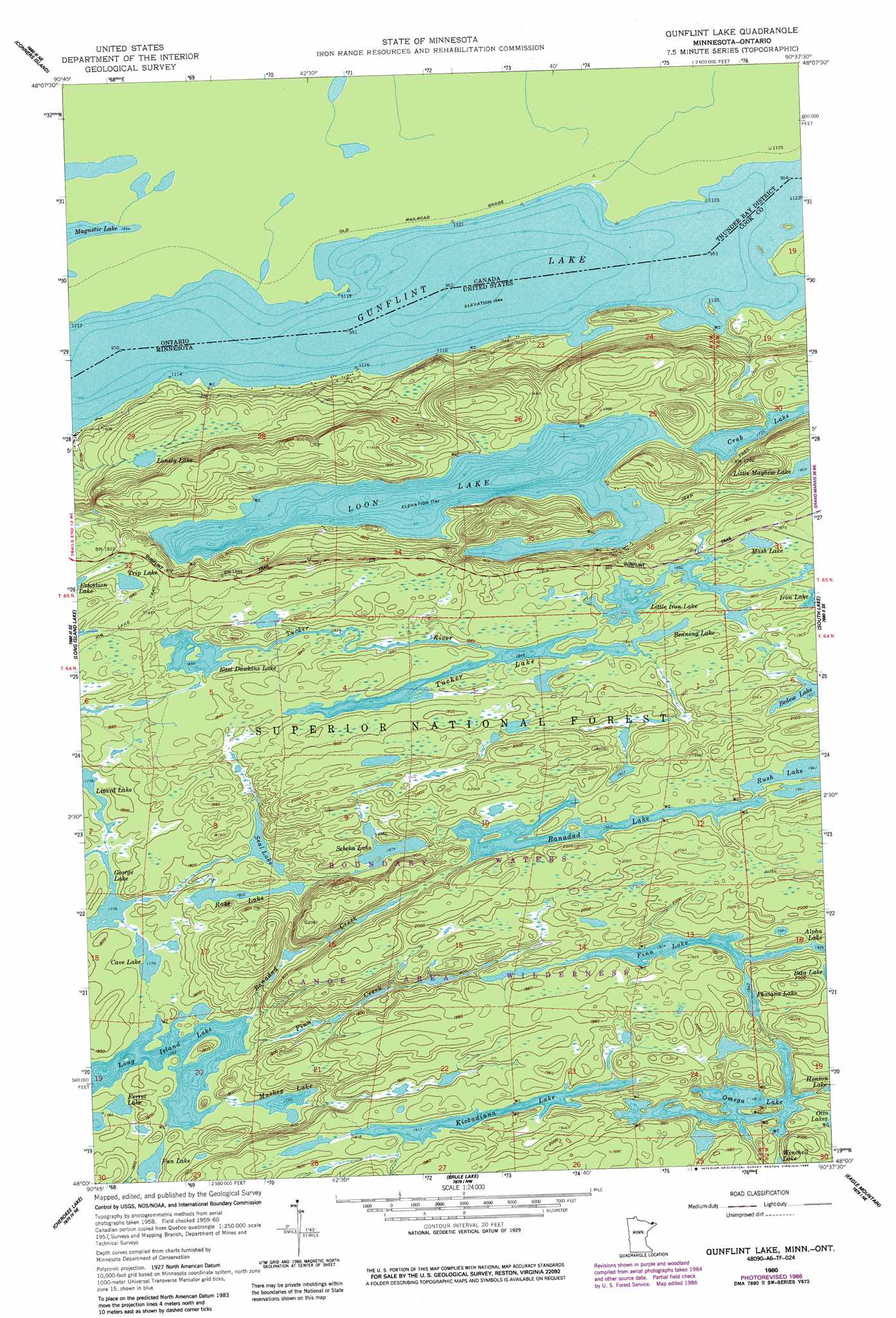
USGS Topo Quad 48090a6 - 1:24,000 scale
| Topo Map Name: | Gunflint Lake |
| USGS Topo Quad ID: | 48090a6 |
| Print Size: | ca. 21 1/4" wide x 27" high |
| Southeast Coordinates: | 48° N latitude / 90.625° W longitude |
| Map Center Coordinates: | 48.0625° N latitude / 90.6875° W longitude |
| U.S. State: | MN |
| Filename: | o48090a6.jpg |
| Download Map JPG Image: | Gunflint Lake topo map 1:24,000 scale |
| Map Type: | Topographic |
| Topo Series: | 7.5´ |
| Map Scale: | 1:24,000 |
| Source of Map Images: | United States Geological Survey (USGS) |
| Alternate Map Versions: |
Gunflint Lake MN 1960, updated 1962 Download PDF Buy paper map Gunflint Lake MN 1960, updated 1965 Download PDF Buy paper map Gunflint Lake MN 1960, updated 1986 Download PDF Buy paper map Gunflint Lake MN 2011 Download PDF Buy paper map Gunflint Lake MN 2013 Download PDF Buy paper map Gunflint Lake MN 2016 Download PDF Buy paper map |
| FStopo: | US Forest Service topo Gunflint Lake is available: Download FStopo PDF Download FStopo TIF |
1:24,000 Topo Quads surrounding Gunflint Lake
Munker Island |
Conners Island |
|||
Gillis Lake |
Long Island Lake |
Gunflint Lake |
South Lake |
Hungry Jack Lake |
Kelso Mountain |
Cherokee Lake |
Brule Lake |
Eagle Mountain |
Lima Mountain |
Beth Lake |
Sawbill Camp |
Tait Lake |
Mark Lake |
Devil Track Lake |
> Back to 48090a1 at 1:100,000 scale
> Back to 48090a1 at 1:250,000 scale
> Back to U.S. Topo Maps home
Gunflint Lake topo map: Gazetteer
Gunflint Lake: Airports
Gunflint Seaplane Base elevation 471m 1545′Gunflint Lake: Lakes
Banadad Lake elevation 592m 1942′Bedew Lake elevation 589m 1932′
Benning Lake elevation 563m 1847′
Cave Lake elevation 541m 1774′
Crab Lake elevation 530m 1738′
East Dawkins Lake elevation 559m 1833′
Ferret Lake elevation 539m 1768′
Finn Lake elevation 588m 1929′
Fun Lake elevation 545m 1788′
George Lake elevation 541m 1774′
Gunflint Lake elevation 463m 1519′
Kiskadinna Lake elevation 584m 1916′
Little Iron Lake elevation 564m 1850′
Lizard Lake elevation 541m 1774′
Lonely Lake elevation 522m 1712′
Loon Lake elevation 531m 1742′
Mash Lake elevation 565m 1853′
Muskeg Lake elevation 540m 1771′
Omega Lake elevation 584m 1916′
Phalanx Lake elevation 592m 1942′
Ross Lake elevation 549m 1801′
Sea Lake elevation 549m 1801′
Sebeka Lake elevation 571m 1873′
Trip Lake elevation 563m 1847′
Tucker Lake elevation 563m 1847′
Gunflint Lake: Streams
Banadad Creek elevation 539m 1768′Finn Creek elevation 537m 1761′
Tucker River elevation 559m 1833′
Gunflint Lake digital topo map on disk
Buy this Gunflint Lake topo map showing relief, roads, GPS coordinates and other geographical features, as a high-resolution digital map file on DVD: