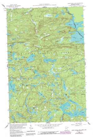
Long Island Lake Topo Map Minnesota
To zoom in, hover over the map of Long Island Lake
USGS Topo Quad 48090a7 - 1:24,000 scale
| Topo Map Name: | Long Island Lake |
| USGS Topo Quad ID: | 48090a7 |
| Print Size: | ca. 21 1/4" wide x 27" high |
| Southeast Coordinates: | 48° N latitude / 90.75° W longitude |
| Map Center Coordinates: | 48.0625° N latitude / 90.8125° W longitude |
| U.S. State: | MN |
| Filename: | o48090a7.jpg |
| Download Map JPG Image: | Long Island Lake topo map 1:24,000 scale |
| Map Type: | Topographic |
| Topo Series: | 7.5´ |
| Map Scale: | 1:24,000 |
| Source of Map Images: | United States Geological Survey (USGS) |
| Alternate Map Versions: |
Long Island Lake MN 1960, updated 1963 Download PDF Buy paper map Long Island Lake MN 1960, updated 1966 Download PDF Buy paper map Long Island Lake MN 1960, updated 1981 Download PDF Buy paper map Long Island Lake MN 1960, updated 1986 Download PDF Buy paper map Long Island Lake MN 2011 Download PDF Buy paper map Long Island Lake MN 2013 Download PDF Buy paper map Long Island Lake MN 2016 Download PDF Buy paper map |
| FStopo: | US Forest Service topo Long Island Lake is available: Download FStopo PDF Download FStopo TIF |
1:24,000 Topo Quads surrounding Long Island Lake
> Back to 48090a1 at 1:100,000 scale
> Back to 48090a1 at 1:250,000 scale
> Back to U.S. Topo Maps home
Long Island Lake topo map: Gazetteer
Long Island Lake: Falls
Little Rock Falls elevation 463m 1519′Long Island Lake: Lakes
Ahgoday Lake elevation 521m 1709′Auk Lake elevation 542m 1778′
Blue Snow Lake elevation 560m 1837′
Brant Lake elevation 536m 1758′
Burt Lake elevation 546m 1791′
Chub Lake elevation 564m 1850′
Contest Lake elevation 548m 1797′
Copper Lake elevation 538m 1765′
Cross Bay Lake elevation 521m 1709′
Dawkins Lake elevation 542m 1778′
Din Lake elevation 577m 1893′
Doe Lake elevation 537m 1761′
Dogleg Lake elevation 526m 1725′
Don Lake elevation 554m 1817′
Edith Lake elevation 537m 1761′
Ell Lake elevation 563m 1847′
Ernest Lake elevation 484m 1587′
Extortion Lake elevation 550m 1804′
Fawn Lake elevation 539m 1768′
Fool Lake elevation 539m 1768′
Fungus Lake elevation 559m 1833′
Hairy Lake elevation 589m 1932′
Ham Lake elevation 518m 1699′
Howl Lake elevation 534m 1751′
Hubbub Lake elevation 539m 1768′
Jester Lake elevation 545m 1788′
Juniper Lake elevation 565m 1853′
Karl Lake elevation 537m 1761′
Kerfoot Lakes elevation 494m 1620′
Little Copper Lake elevation 565m 1853′
Long Island Lake elevation 537m 1761′
Lower George Lake elevation 532m 1745′
Lucky Pay Lake elevation 538m 1765′
Magnetic Lake elevation 471m 1545′
Mass Lake elevation 576m 1889′
Mavis Lake elevation 553m 1814′
Mine Lake elevation 541m 1774′
Missing Link Lake elevation 560m 1837′
Moth Lake elevation 545m 1788′
Plug Lake elevation 564m 1850′
Pogo Lake elevation 523m 1715′
Ragged Lake elevation 570m 1870′
Rib Lake elevation 529m 1735′
Round Lake elevation 532m 1745′
Snipe Lake elevation 530m 1738′
Sora Lake elevation 576m 1889′
Swollen Ankle Lake elevation 545m 1788′
Tame Lake elevation 578m 1896′
Thelma Lake elevation 520m 1706′
West Round Lake elevation 535m 1755′
Wish Lake elevation 541m 1774′
Yogi Lake elevation 545m 1788′
Long Island Lake: Streams
Cross River elevation 471m 1545′Dawkins Creek elevation 521m 1709′
Extortion Creek elevation 521m 1709′
Ham Creek elevation 520m 1706′
Long Island River elevation 537m 1761′
Long Island Lake: Trails
Rib Lake Trail elevation 550m 1804′Long Island Lake digital topo map on disk
Buy this Long Island Lake topo map showing relief, roads, GPS coordinates and other geographical features, as a high-resolution digital map file on DVD:


