Marion Lake Topo Map Minnesota
To zoom in, hover over the map of Marion Lake
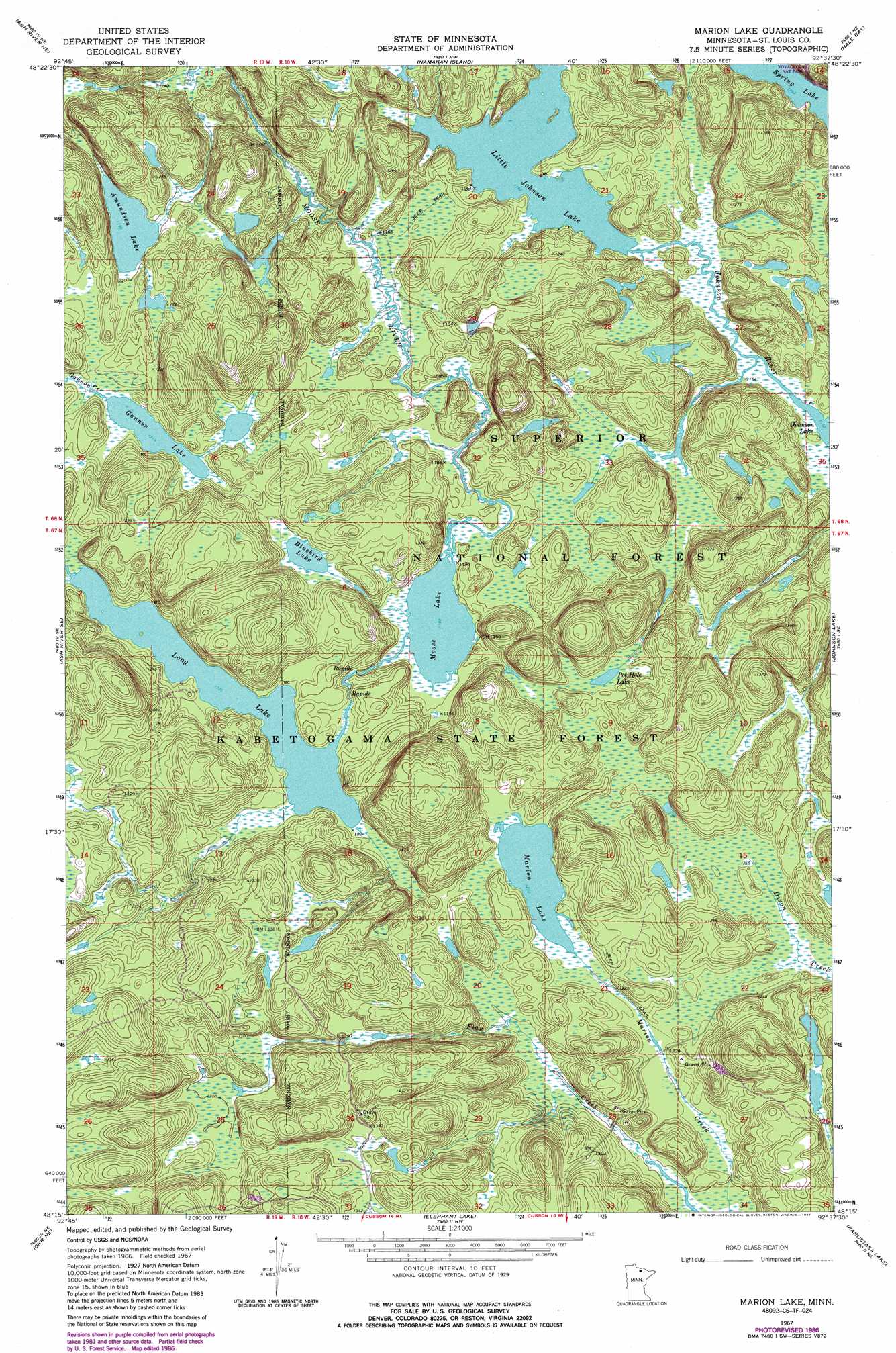
USGS Topo Quad 48092c6 - 1:24,000 scale
| Topo Map Name: | Marion Lake |
| USGS Topo Quad ID: | 48092c6 |
| Print Size: | ca. 21 1/4" wide x 27" high |
| Southeast Coordinates: | 48.25° N latitude / 92.625° W longitude |
| Map Center Coordinates: | 48.3125° N latitude / 92.6875° W longitude |
| U.S. State: | MN |
| Filename: | o48092c6.jpg |
| Download Map JPG Image: | Marion Lake topo map 1:24,000 scale |
| Map Type: | Topographic |
| Topo Series: | 7.5´ |
| Map Scale: | 1:24,000 |
| Source of Map Images: | United States Geological Survey (USGS) |
| Alternate Map Versions: |
Marion Lake MN 1967, updated 1969 Download PDF Buy paper map Marion Lake MN 1967, updated 1970 Download PDF Buy paper map Marion Lake MN 1967, updated 1983 Download PDF Buy paper map Marion Lake MN 1967, updated 1987 Download PDF Buy paper map Marion Lake MN 1999, updated 2003 Download PDF Buy paper map Marion Lake MN 2011 Download PDF Buy paper map Marion Lake MN 2013 Download PDF Buy paper map Marion Lake MN 2016 Download PDF Buy paper map |
| FStopo: | US Forest Service topo Marion Lake is available: Download FStopo PDF Download FStopo TIF |
1:24,000 Topo Quads surrounding Marion Lake
Soldier Point |
Kempton Bay |
Kettle Falls |
||
Daley Bay |
Ash River Ne |
Namakan Island |
Hale Bay |
Redhorse Bay |
Ash River Sw |
Ash River Se |
Marion Lake |
Johnson Lake |
Crane Lake |
Ash Lake |
Orr Ne |
Elephant Lake |
Kabustasa Lake |
Echo Lake |
Orr Sw |
Orr |
Myrtle Lake |
Buyck |
Picket Lake |
> Back to 48092a1 at 1:100,000 scale
> Back to 48092a1 at 1:250,000 scale
> Back to U.S. Topo Maps home
Marion Lake topo map: Gazetteer
Marion Lake: Lakes
Amundsen Lake elevation 365m 1197′Bluebird Lake elevation 374m 1227′
Gannon Lake elevation 371m 1217′
Little Johnson Lake elevation 355m 1164′
Long Lake elevation 374m 1227′
Marion Lake elevation 374m 1227′
Moose Lake elevation 361m 1184′
Pot Hole Lake elevation 376m 1233′
Spring Lake elevation 355m 1164′
Marion Lake digital topo map on disk
Buy this Marion Lake topo map showing relief, roads, GPS coordinates and other geographical features, as a high-resolution digital map file on DVD: