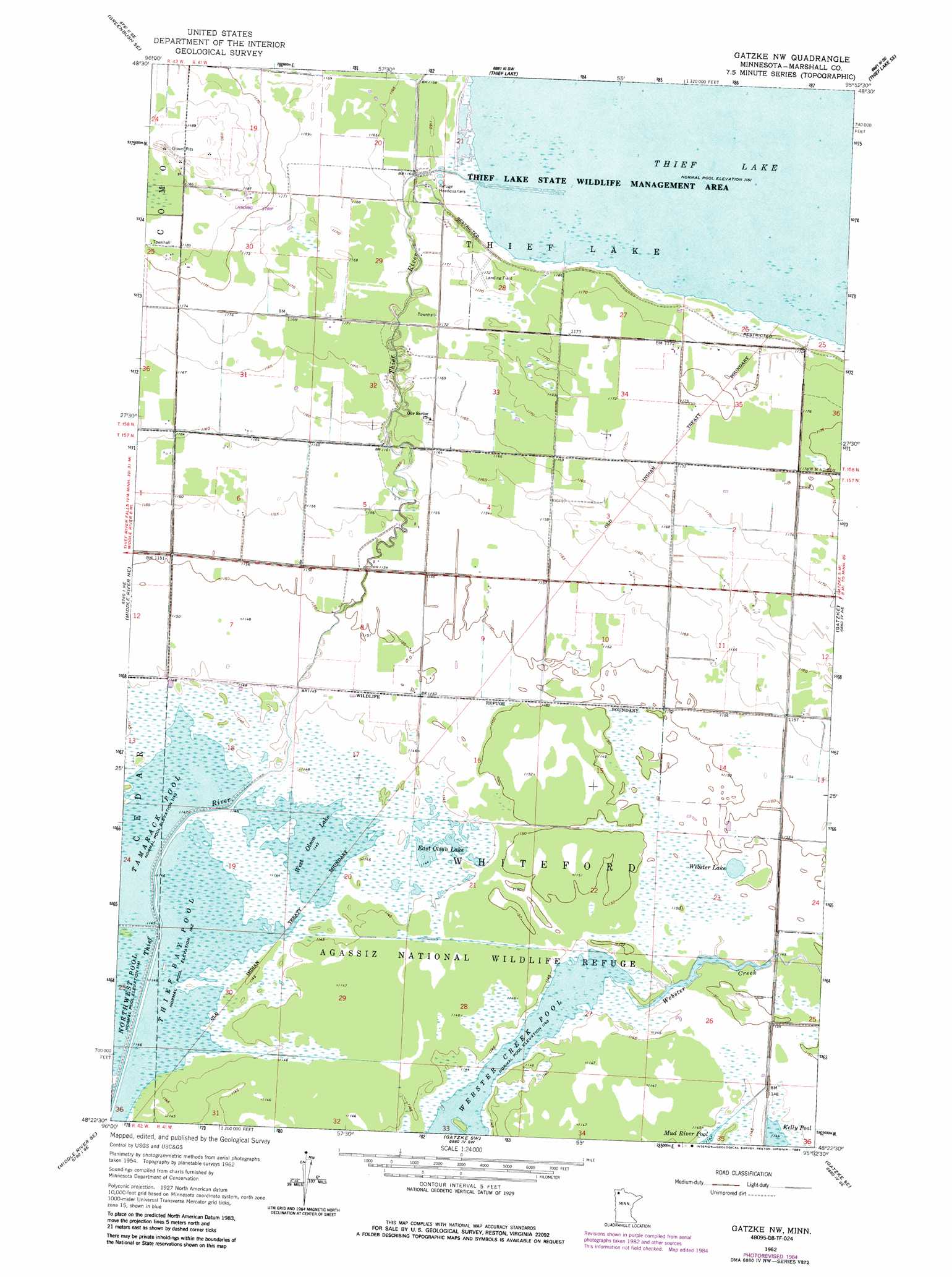
Gatzke Nw Topo Map Minnesota
To zoom in, hover over the map of Gatzke Nw
USGS Topo Quad 48095d8 - 1:24,000 scale
| Topo Map Name: | Gatzke Nw |
| USGS Topo Quad ID: | 48095d8 |
| Print Size: | ca. 21 1/4" wide x 27" high |
| Southeast Coordinates: | 48.375° N latitude / 95.875° W longitude |
| Map Center Coordinates: | 48.4375° N latitude / 95.9375° W longitude |
| U.S. State: | MN |
| Filename: | o48095d8.jpg |
| Download Map JPG Image: | Gatzke Nw topo map 1:24,000 scale |
| Map Type: | Topographic |
| Topo Series: | 7.5´ |
| Map Scale: | 1:24,000 |
| Source of Map Images: | United States Geological Survey (USGS) |
| Alternate Map Versions: |
Gatzke NW MN 1962, updated 1964 Download PDF Buy paper map Gatzke NW MN 1962, updated 1984 Download PDF Buy paper map Gatzke NW MN 2010 Download PDF Buy paper map Gatzke NW MN 2013 Download PDF Buy paper map Gatzke NW MN 2016 Download PDF Buy paper map |
1:24,000 Topo Quads surrounding Gatzke Nw
Greenbush |
Greenbush Ne |
Thief Lake Nw |
Thief Lake Ne |
Wannaska |
Strathcona |
Greenbush Se |
Thief Lake |
Thief Lake Se |
Wannaska Sw |
Middle River |
Middle River Ne |
Gatzke Nw |
Gatzke |
Randeen Ridge |
Holt |
Middle River Se |
Gatzke Sw |
Gatzke Se |
Grygla Sw |
Thief River Falls Nw |
Thief River Falls Ne |
Mavie |
Goodridge |
Erie Nw |
> Back to 48095a1 at 1:100,000 scale
> Back to 48094a1 at 1:250,000 scale
> Back to U.S. Topo Maps home
Gatzke Nw topo map: Gazetteer
Gatzke Nw: Dams
Pool One Dam elevation 348m 1141′Gatzke Nw: Lakes
East Olson Lake elevation 349m 1145′Thief Lake elevation 354m 1161′
Webster Lake elevation 351m 1151′
West Olson Lake elevation 349m 1145′
Gatzke Nw: Parks
Thief Lake State Wildlife Management Area elevation 354m 1161′Gatzke Nw: Post Offices
Jane Post Office (historical) elevation 355m 1164′Gatzke Nw: Reservoirs
Northwest Pool elevation 349m 1145′Tamarac Pool elevation 348m 1141′
Tamarack Pool elevation 349m 1145′
Thief Bay Pool elevation 349m 1145′
Gatzke Nw: Streams
Webster Creek elevation 349m 1145′Gatzke Nw digital topo map on disk
Buy this Gatzke Nw topo map showing relief, roads, GPS coordinates and other geographical features, as a high-resolution digital map file on DVD: