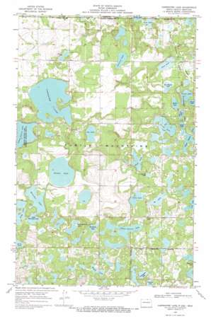
Carpenter Lake Topo Map North Dakota
To zoom in, hover over the map of Carpenter Lake
USGS Topo Quad 48099h8 - 1:24,000 scale
| Topo Map Name: | Carpenter Lake |
| USGS Topo Quad ID: | 48099h8 |
| Print Size: | ca. 21 1/4" wide x 27" high |
| Southeast Coordinates: | 48.875° N latitude / 99.875° W longitude |
| Map Center Coordinates: | 48.9375° N latitude / 99.9375° W longitude |
| U.S. State: | ND |
| Filename: | O48099H8.jpg |
| Download Map JPG Image: | Carpenter Lake topo map 1:24,000 scale |
| Map Type: | Topographic |
| Topo Series: | 7.5´ |
| Map Scale: | 1:24,000 |
| Source of Map Images: | United States Geological Survey (USGS) |
| Alternate Map Versions: |
Carpenter Lake ND 1968, updated 1971 Download PDF Buy paper map Carpenter Lake ND 2011 Download PDF Buy paper map Carpenter Lake ND 2014 Download PDF Buy paper map |
1:24,000 Topo Quads surrounding Carpenter Lake
Boundary Lake |
International Peace Garden |
Carpenter Lake |
Lake Upsilon |
Saint John |
Lords Lake |
Dunseith |
Lake Upsilon Sw |
Lake Upsilon Se |
Belcourt |
Overly |
Fonda |
Thorne |
Rolette |
Mylo Nw |
> Back to 48099e1 at 1:100,000 scale
> Back to 48098a1 at 1:250,000 scale
> Back to U.S. Topo Maps home
Carpenter Lake topo map: Gazetteer
Carpenter Lake: Dams
Wakopa Dam elevation 638m 2093′Carpenter Lake: Lakes
Ben Waters Lake elevation 642m 2106′Bu Lake elevation 651m 2135′
Cain Lake elevation 654m 2145′
Carpenter Lake elevation 667m 2188′
Cassidy Lake elevation 651m 2135′
Coon Lake elevation 627m 2057′
Dion Lake elevation 641m 2103′
Donald Lake elevation 651m 2135′
Gravel Bottom Lake elevation 651m 2135′
Hooker Lake elevation 648m 2125′
Horseshoe Lake elevation 648m 2125′
Huff Lake elevation 641m 2103′
Island Lake elevation 639m 2096′
Jay Lake elevation 676m 2217′
Little Horseshoe Lake elevation 648m 2125′
Long Lake elevation 648m 2125′
Magog Lake elevation 647m 2122′
Olson Lake elevation 639m 2096′
Purdy Lake elevation 640m 2099′
School Section Lake elevation 658m 2158′
School Section Lake elevation 639m 2096′
School Section Lake elevation 667m 2188′
Streitzel Lake elevation 673m 2208′
Sucker Lake elevation 651m 2135′
Villneauve Lake elevation 654m 2145′
Warner Lake elevation 645m 2116′
Wendland Lake elevation 660m 2165′
Ziegler Lake elevation 663m 2175′
Carpenter Lake: Parks
School Section Lake National Wildlife Refuge elevation 667m 2188′Wakopa State Game Management Area elevation 637m 2089′
Carpenter Lake digital topo map on disk
Buy this Carpenter Lake topo map showing relief, roads, GPS coordinates and other geographical features, as a high-resolution digital map file on DVD:
Eastern North Dakota & Eastern South Dakota
Buy digital topo maps: Eastern North Dakota & Eastern South Dakota


