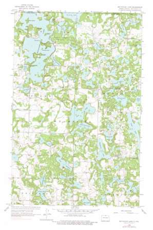
Metigoshe Lake Topo Map North Dakota
To zoom in, hover over the map of Metigoshe Lake
USGS Topo Quad 48100h3 - 1:24,000 scale
| Topo Map Name: | Metigoshe Lake |
| USGS Topo Quad ID: | 48100h3 |
| Print Size: | ca. 21 1/4" wide x 27" high |
| Southeast Coordinates: | 48.875° N latitude / 100.25° W longitude |
| Map Center Coordinates: | 48.9375° N latitude / 100.3125° W longitude |
| U.S. State: | ND |
| Filename: | O48100H3.jpg |
| Download Map JPG Image: | Metigoshe Lake topo map 1:24,000 scale |
| Map Type: | Topographic |
| Topo Series: | 7.5´ |
| Map Scale: | 1:24,000 |
| Source of Map Images: | United States Geological Survey (USGS) |
| Alternate Map Versions: |
Metigoshe Lake ND 1956, updated 1957 Download PDF Buy paper map Metigoshe Lake ND 1956, updated 1976 Download PDF Buy paper map Metigoshe Lake ND 2011 Download PDF Buy paper map Metigoshe Lake ND 2014 Download PDF Buy paper map |
1:24,000 Topo Quads surrounding Metigoshe Lake
Carbury |
Lake Klingenberg |
Metigoshe Lake |
Boundary Lake |
International Peace Garden |
Souris Se |
Bottineau |
Bottineau Se |
Lords Lake |
Dunseith |
Upham Ne |
Gardena |
Omemee |
Overly |
Fonda |
> Back to 48100e1 at 1:100,000 scale
> Back to 48100a1 at 1:250,000 scale
> Back to U.S. Topo Maps home
Metigoshe Lake topo map: Gazetteer
Metigoshe Lake: Capes
Rugby Point elevation 658m 2158′Squaw Point elevation 661m 2168′
Metigoshe Lake: Dams
Lake Metigoshe Dam elevation 653m 2142′Metigoshe Lake: Gaps
The Narrows elevation 652m 2139′Metigoshe Lake: Islands
Bear Island elevation 659m 2162′Mackay Island elevation 654m 2145′
Masonic Island elevation 656m 2152′
Metigoshe Lake: Lakes
Bear Lake elevation 654m 2145′Bittener Lake elevation 669m 2194′
Brager Lake elevation 668m 2191′
Cavalier Lake elevation 673m 2208′
Deep Lake elevation 667m 2188′
Grigg Lake elevation 667m 2188′
Hemming Lake elevation 672m 2204′
Klebe Lake elevation 668m 2191′
Lake Bennett elevation 654m 2145′
Lake Bessie elevation 652m 2139′
Lake McDonald elevation 652m 2139′
Lake Thomas elevation 667m 2188′
Lee Lake elevation 670m 2198′
Long Lake elevation 661m 2168′
Loon Lake elevation 675m 2214′
Mud Lake elevation 656m 2152′
Mud Lake elevation 652m 2139′
Norberg Lake elevation 666m 2185′
Pelican Lake elevation 666m 2185′
Sand Lake elevation 663m 2175′
School Section Lake elevation 654m 2145′
Sivertson Lake elevation 667m 2188′
Smithsrund Lake elevation 667m 2188′
South Loon Lake elevation 677m 2221′
Metigoshe Lake: Parks
Lake Metigoshe State Park elevation 656m 2152′Metigoshe Lake: Reservoirs
Metigoshe Lake elevation 653m 2142′Metigoshe Lake digital topo map on disk
Buy this Metigoshe Lake topo map showing relief, roads, GPS coordinates and other geographical features, as a high-resolution digital map file on DVD:
Eastern North Dakota & Eastern South Dakota
Buy digital topo maps: Eastern North Dakota & Eastern South Dakota


