Red Mike Hill Topo Map North Dakota
To zoom in, hover over the map of Red Mike Hill
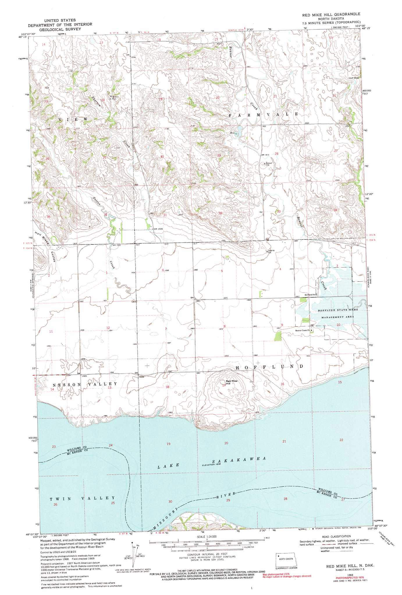
USGS Topo Quad 48103b1 - 1:24,000 scale
| Topo Map Name: | Red Mike Hill |
| USGS Topo Quad ID: | 48103b1 |
| Print Size: | ca. 21 1/4" wide x 27" high |
| Southeast Coordinates: | 48.125° N latitude / 103° W longitude |
| Map Center Coordinates: | 48.1875° N latitude / 103.0625° W longitude |
| U.S. State: | ND |
| Filename: | O48103B1.jpg |
| Download Map JPG Image: | Red Mike Hill topo map 1:24,000 scale |
| Map Type: | Topographic |
| Topo Series: | 7.5´ |
| Map Scale: | 1:24,000 |
| Source of Map Images: | United States Geological Survey (USGS) |
| Alternate Map Versions: |
Red Mike Hill ND 1969, updated 1972 Download PDF Buy paper map Red Mike Hill ND 1969, updated 1990 Download PDF Buy paper map Red Mike Hill ND 1997, updated 2001 Download PDF Buy paper map Red Mike Hill ND 2011 Download PDF Buy paper map Red Mike Hill ND 2014 Download PDF Buy paper map |
| FStopo: | US Forest Service topo Red Mike Hill is available: Download FStopo PDF Download FStopo TIF |
1:24,000 Topo Quads surrounding Red Mike Hill
Epping Ne |
Ray Nw |
Temple |
Tioga |
White Earth |
Epping |
Ray |
Ray Se |
Tioga Sw |
Tioga Se |
Gamache Creek |
Cussicks Spring |
Red Mike Hill |
Charlson Nw |
Charlson Ne |
Chris Creek |
Banks |
Tobacco Garden Bay |
Charlson Sw |
Charlson |
Watford City Ne |
Timber Prong Creek |
Demicks Lake |
Keene |
Blue Buttes |
> Back to 48103a1 at 1:100,000 scale
> Back to 48102a1 at 1:250,000 scale
> Back to U.S. Topo Maps home
Red Mike Hill topo map: Gazetteer
Red Mike Hill: Islands
Bear Island (historical) elevation 561m 1840′Red Mike Hill: Parks
Hofflund State Game Management Area elevation 564m 1850′Red Mike Hill: Streams
Nelson Creek elevation 573m 1879′Thorsen Creek elevation 576m 1889′
Red Mike Hill: Summits
Red Mike Hill elevation 611m 2004′Red Mike Hill: Valleys
Half Breed Coulee elevation 586m 1922′Red Mike Hill digital topo map on disk
Buy this Red Mike Hill topo map showing relief, roads, GPS coordinates and other geographical features, as a high-resolution digital map file on DVD:
Eastern Montana & Western North Dakota
Buy digital topo maps: Eastern Montana & Western North Dakota