Cussicks Spring Topo Map North Dakota
To zoom in, hover over the map of Cussicks Spring
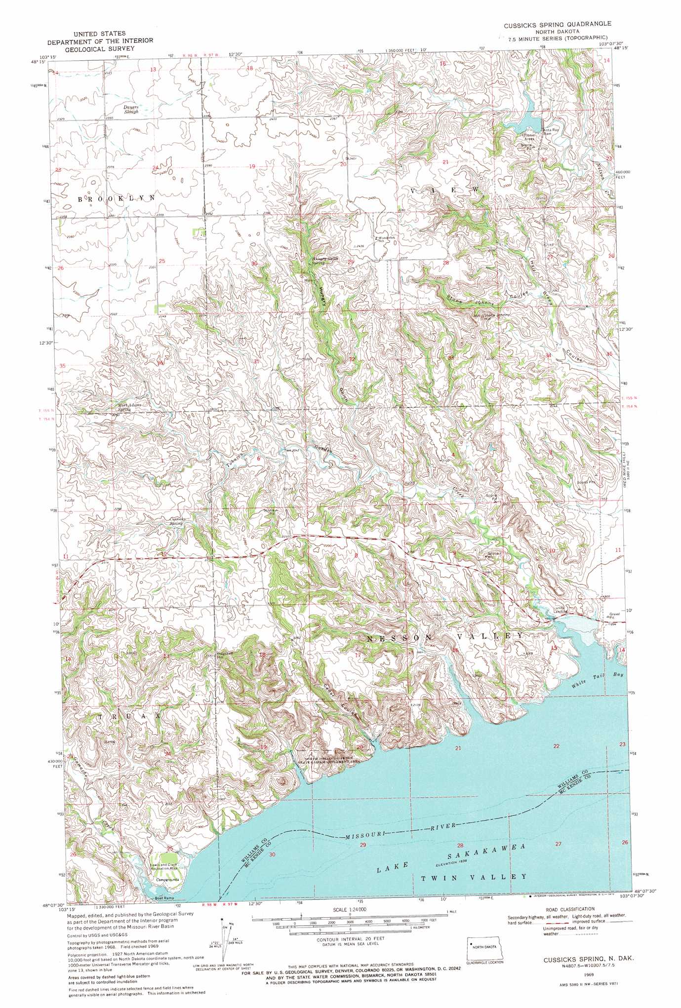
USGS Topo Quad 48103b2 - 1:24,000 scale
| Topo Map Name: | Cussicks Spring |
| USGS Topo Quad ID: | 48103b2 |
| Print Size: | ca. 21 1/4" wide x 27" high |
| Southeast Coordinates: | 48.125° N latitude / 103.125° W longitude |
| Map Center Coordinates: | 48.1875° N latitude / 103.1875° W longitude |
| U.S. State: | ND |
| Filename: | O48103B2.jpg |
| Download Map JPG Image: | Cussicks Spring topo map 1:24,000 scale |
| Map Type: | Topographic |
| Topo Series: | 7.5´ |
| Map Scale: | 1:24,000 |
| Source of Map Images: | United States Geological Survey (USGS) |
| Alternate Map Versions: |
Cussicks Spring ND 1969, updated 1972 Download PDF Buy paper map Cussicks Spring ND 2011 Download PDF Buy paper map Cussicks Spring ND 2014 Download PDF Buy paper map |
1:24,000 Topo Quads surrounding Cussicks Spring
Epping Nw |
Epping Ne |
Ray Nw |
Temple |
Tioga |
Spring Brook |
Epping |
Ray |
Ray Se |
Tioga Sw |
Stockyard Creek |
Gamache Creek |
Cussicks Spring |
Red Mike Hill |
Charlson Nw |
Lake Jessie |
Chris Creek |
Banks |
Tobacco Garden Bay |
Charlson Sw |
Watford City Nw |
Watford City Ne |
Timber Prong Creek |
Demicks Lake |
Keene |
> Back to 48103a1 at 1:100,000 scale
> Back to 48102a1 at 1:250,000 scale
> Back to U.S. Topo Maps home
Cussicks Spring topo map: Gazetteer
Cussicks Spring: Bays
White Tail Bay elevation 561m 1840′Cussicks Spring: Capes
Spanish Point (historical) elevation 561m 1840′Cussicks Spring: Cliffs
David Watts Bluff (historical) elevation 635m 2083′Cussicks Spring: Dams
Kota Ray Dam elevation 645m 2116′Ray Dam elevation 643m 2109′
Cussicks Spring: Guts
Dauers Slough elevation 715m 2345′Cussicks Spring: Parks
Lewis and Clark Recreation Area elevation 570m 1870′North Tobacco Garden State Game Management Area elevation 594m 1948′
Cussicks Spring: Populated Places
Lunds Landing elevation 562m 1843′Cussicks Spring: Post Offices
Nesson Post Office (historical) elevation 561m 1840′Cussicks Spring: Springs
Cussicks Spring elevation 654m 2145′Hungry Gulch Spring elevation 681m 2234′
Mort Adams Spring elevation 683m 2240′
Cussicks Spring: Streams
Gamache Creek elevation 561m 1840′Tobacco Garden Creek elevation 561m 1840′
Cussicks Spring: Summits
Flagstaff Hill elevation 720m 2362′Stone Johnny Hill elevation 709m 2326′
Cussicks Spring: Valleys
Cedar Coulee elevation 561m 1840′Hungry Gulch elevation 603m 1978′
Stone Johnny Coulee elevation 625m 2050′
Cussicks Spring digital topo map on disk
Buy this Cussicks Spring topo map showing relief, roads, GPS coordinates and other geographical features, as a high-resolution digital map file on DVD:
Eastern Montana & Western North Dakota
Buy digital topo maps: Eastern Montana & Western North Dakota