Mccabe East Topo Map Montana
To zoom in, hover over the map of Mccabe East
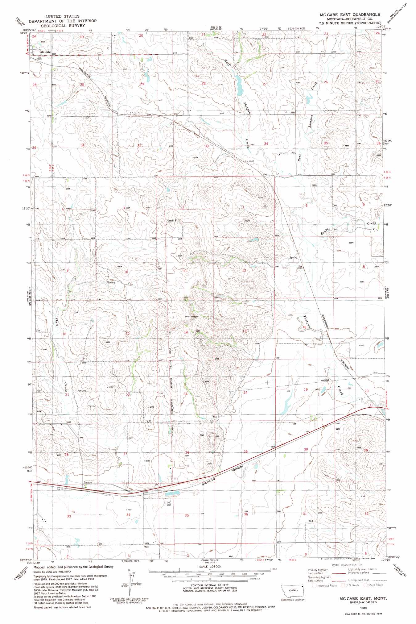
USGS Topo Quad 48104b3 - 1:24,000 scale
| Topo Map Name: | Mccabe East |
| USGS Topo Quad ID: | 48104b3 |
| Print Size: | ca. 21 1/4" wide x 27" high |
| Southeast Coordinates: | 48.125° N latitude / 104.25° W longitude |
| Map Center Coordinates: | 48.1875° N latitude / 104.3125° W longitude |
| U.S. State: | MT |
| Filename: | o48104b3.jpg |
| Download Map JPG Image: | Mccabe East topo map 1:24,000 scale |
| Map Type: | Topographic |
| Topo Series: | 7.5´ |
| Map Scale: | 1:24,000 |
| Source of Map Images: | United States Geological Survey (USGS) |
| Alternate Map Versions: |
Mc Cabe East MT 1983, updated 1984 Download PDF Buy paper map McCabe East MT 2011 Download PDF Buy paper map McCabe East MT 2014 Download PDF Buy paper map |
1:24,000 Topo Quads surrounding Mccabe East
Homestead |
Medicine Lake |
Capeneys Lake |
Sunnyhill School |
Brush Mountain |
Johnson Lake |
Froid |
Froid Se |
Brush Mountain Sw |
Bull Butte |
Culbertson |
Mccabe West |
Mccabe East |
Bainville |
Red Bank Creek |
Dugout Creek |
Three Buttes |
Cedar Coulee |
Bainville Sw |
Bainville Se |
Andes |
Blue Hill |
Sioux Pass |
Fairview Nw |
Dore |
> Back to 48104a1 at 1:100,000 scale
> Back to 48104a1 at 1:250,000 scale
> Back to U.S. Topo Maps home
Mccabe East topo map: Gazetteer
Mccabe East: Dams
Hansen Dam elevation 664m 2178′Ward Reservoir Dam elevation 633m 2076′
Mccabe East: Populated Places
Lanark elevation 604m 1981′Mccabe East: Post Offices
Lanark Post Office (historical) elevation 604m 1981′Mccabe East: Streams
East Shotgun Creek elevation 618m 2027′Shell Creek elevation 605m 1984′
Snake Creek elevation 614m 2014′
West Shotgun Creek elevation 618m 2027′
Mccabe East: Wells
27N57E02AA__01 Well elevation 599m 1965′27N57E04AB__01 Well elevation 605m 1984′
27N58E06BB__01 Well elevation 616m 2020′
28N41E36ADDB01 Well elevation 602m 1975′
28N57E04AB__01 Well elevation 683m 2240′
28N57E04BD__01 Well elevation 683m 2240′
28N57E04DC__01 Well elevation 663m 2175′
28N57E09CC__01 Well elevation 645m 2116′
28N57E10BB__01 Well elevation 671m 2201′
28N57E13DA__01 Well elevation 629m 2063′
28N57E13DA__02 Well elevation 629m 2063′
28N57E13DA__03 Well elevation 629m 2063′
28N57E16CD__01 Well elevation 634m 2080′
28N57E16CD__02 Well elevation 634m 2080′
28N57E25BA__01 Well elevation 607m 1991′
28N57E25CB__01 Well elevation 605m 1984′
28N57E25CC__01 Well elevation 598m 1961′
28N57E25CC__02 Well elevation 598m 1961′
28N57E26CA__01 Well elevation 611m 2004′
28N57E26CA__02 Well elevation 611m 2004′
28N57E28CD__01 Well elevation 608m 1994′
28N57E28DC__01 Well elevation 604m 1981′
28N57E28DD__01 Well elevation 607m 1991′
28N57E33AA__01 Well elevation 604m 1981′
28N57E33AB__01 Well elevation 603m 1978′
28N57E33CB__01 Well elevation 602m 1975′
28N57E34DD__01 Well elevation 602m 1975′
28N57E35AB__01 Well elevation 595m 1952′
28N57E36AB__01 Well elevation 600m 1968′
28N57E36DD__01 Well elevation 608m 1994′
28N58E07BC__01 Well elevation 624m 2047′
28N58E07BC__02 Well elevation 624m 2047′
28N58E17CA__01 Well elevation 617m 2024′
28N58E17CA__02 Well elevation 617m 2024′
28N58E18DB__01 Well elevation 611m 2004′
28N58E19DC__01 Well elevation 613m 2011′
28N58E19DCDC01 Well elevation 611m 2004′
28N58E19DD__01 Well elevation 613m 2011′
28N58E31BB__01 Well elevation 609m 1998′
28N58E31BB__02 Well elevation 609m 1998′
28N58E31BB__03 Well elevation 609m 1998′
28N58E31DB__01 Well elevation 632m 2073′
29N57E30BCBB01 Well elevation 678m 2224′
29N57E32BBBC01 Well elevation 652m 2139′
Mccabe East digital topo map on disk
Buy this Mccabe East topo map showing relief, roads, GPS coordinates and other geographical features, as a high-resolution digital map file on DVD:
Eastern Montana & Western North Dakota
Buy digital topo maps: Eastern Montana & Western North Dakota