Fort Kipp Topo Map Montana
To zoom in, hover over the map of Fort Kipp
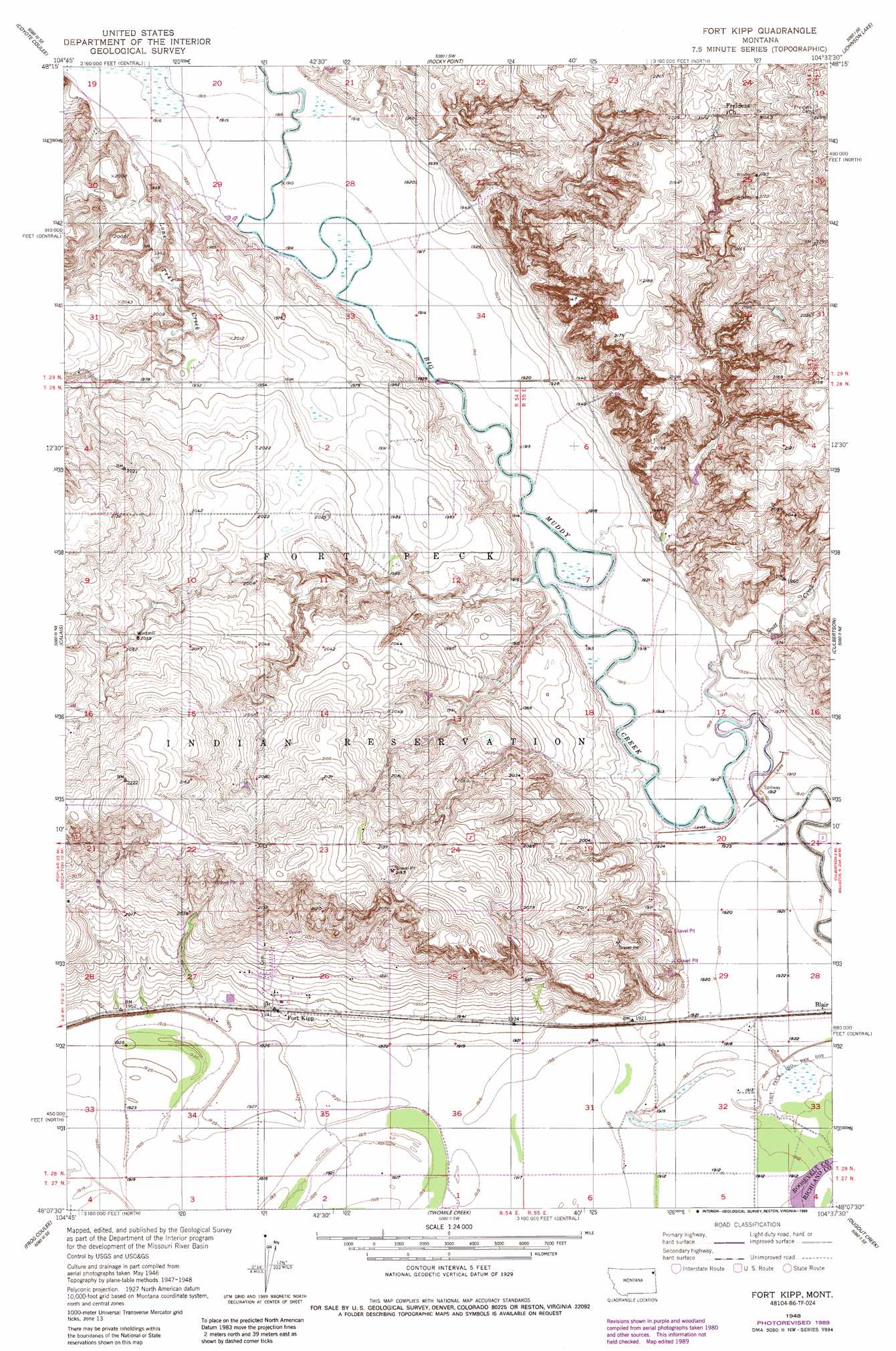
USGS Topo Quad 48104b6 - 1:24,000 scale
| Topo Map Name: | Fort Kipp |
| USGS Topo Quad ID: | 48104b6 |
| Print Size: | ca. 21 1/4" wide x 27" high |
| Southeast Coordinates: | 48.125° N latitude / 104.625° W longitude |
| Map Center Coordinates: | 48.1875° N latitude / 104.6875° W longitude |
| U.S. State: | MT |
| Filename: | o48104b6.jpg |
| Download Map JPG Image: | Fort Kipp topo map 1:24,000 scale |
| Map Type: | Topographic |
| Topo Series: | 7.5´ |
| Map Scale: | 1:24,000 |
| Source of Map Images: | United States Geological Survey (USGS) |
| Alternate Map Versions: |
Fort Kipp MT 1948, updated 1989 Download PDF Buy paper map Fort Kipp MT 1949, updated 1949 Download PDF Buy paper map Fort Kipp MT 2011 Download PDF Buy paper map Fort Kipp MT 2014 Download PDF Buy paper map |
1:24,000 Topo Quads surrounding Fort Kipp
Beam School |
Smoke Creek Ne |
Homestead Nw |
Homestead |
Medicine Lake |
Smoke Creek Sw |
Coyote Coulee |
Rocky Point |
Johnson Lake |
Froid |
Brockton |
Calais |
Fort Kipp |
Culbertson |
Mccabe West |
Mortarstone Bluff |
Frog Coulee |
Twomile Creek |
Dugout Creek |
Three Buttes |
Elmdale Nw |
Elmdale |
Elm Coulee |
Andes |
Blue Hill |
> Back to 48104a1 at 1:100,000 scale
> Back to 48104a1 at 1:250,000 scale
> Back to U.S. Topo Maps home
Fort Kipp topo map: Gazetteer
Fort Kipp: Populated Places
Blair elevation 587m 1925′Boyd (historical) elevation 586m 1922′
Fort Kipp elevation 592m 1942′
Fort Kipp: Post Offices
Boyd Post Office (historical) elevation 586m 1922′Fort Kipp: Streams
Lone Tree Creek elevation 584m 1916′Scott Creek elevation 582m 1909′
Fort Kipp: Wells
28N54E02DCCC01 Well elevation 617m 2024′28N54E03ADDA01 Well elevation 618m 2027′
28N54E16DB__01 Well elevation 643m 2109′
28N54E16DBBD01 Well elevation 644m 2112′
28N54E21DC__01 Well elevation 627m 2057′
28N54E23AD__01 Well elevation 655m 2148′
28N54E25BC__01 Well elevation 617m 2024′
28N54E25DB__01 Well elevation 604m 1981′
28N54E26BD__01 Well elevation 610m 2001′
28N54E26CB__01 Well elevation 597m 1958′
28N54E26CB__02 Well elevation 597m 1958′
28N54E26CD__01 Well elevation 588m 1929′
28N54E26CD__02 Well elevation 588m 1929′
28N54E26DB__01 Well elevation 597m 1958′
28N54E26DB__02 Well elevation 597m 1958′
28N54E26DD__01 Well elevation 591m 1938′
28N54E27AD__01 Well elevation 602m 1975′
28N54E27BC__01 Well elevation 604m 1981′
28N54E27BC__02 Well elevation 604m 1981′
28N54E27DC__01 Well elevation 583m 1912′
28N54E33AD__01 Well elevation 586m 1922′
28N54E33DD__01 Well elevation 586m 1922′
28N54E35CA__01 Well elevation 587m 1925′
28N54E35CAAB01 Well elevation 585m 1919′
28N54E35DD__01 Well elevation 585m 1919′
28N54E36BB__01 Well elevation 586m 1922′
28N55E06ABAC01 Well elevation 604m 1981′
28N55E28BB__01 Well elevation 585m 1919′
28N55E28BBBB01 Well elevation 586m 1922′
28N55E29BB__01 Well elevation 589m 1932′
28N55E29DC__01 Well elevation 587m 1925′
28N55E30DD__01 Well elevation 587m 1925′
28N55E31AD__01 Well elevation 584m 1916′
28N55E32AC__01 Well elevation 583m 1912′
28N55E32BA__01 Well elevation 586m 1922′
Fort Kipp digital topo map on disk
Buy this Fort Kipp topo map showing relief, roads, GPS coordinates and other geographical features, as a high-resolution digital map file on DVD:
Eastern Montana & Western North Dakota
Buy digital topo maps: Eastern Montana & Western North Dakota