Shippe Canyon Topo Map Montana
To zoom in, hover over the map of Shippe Canyon
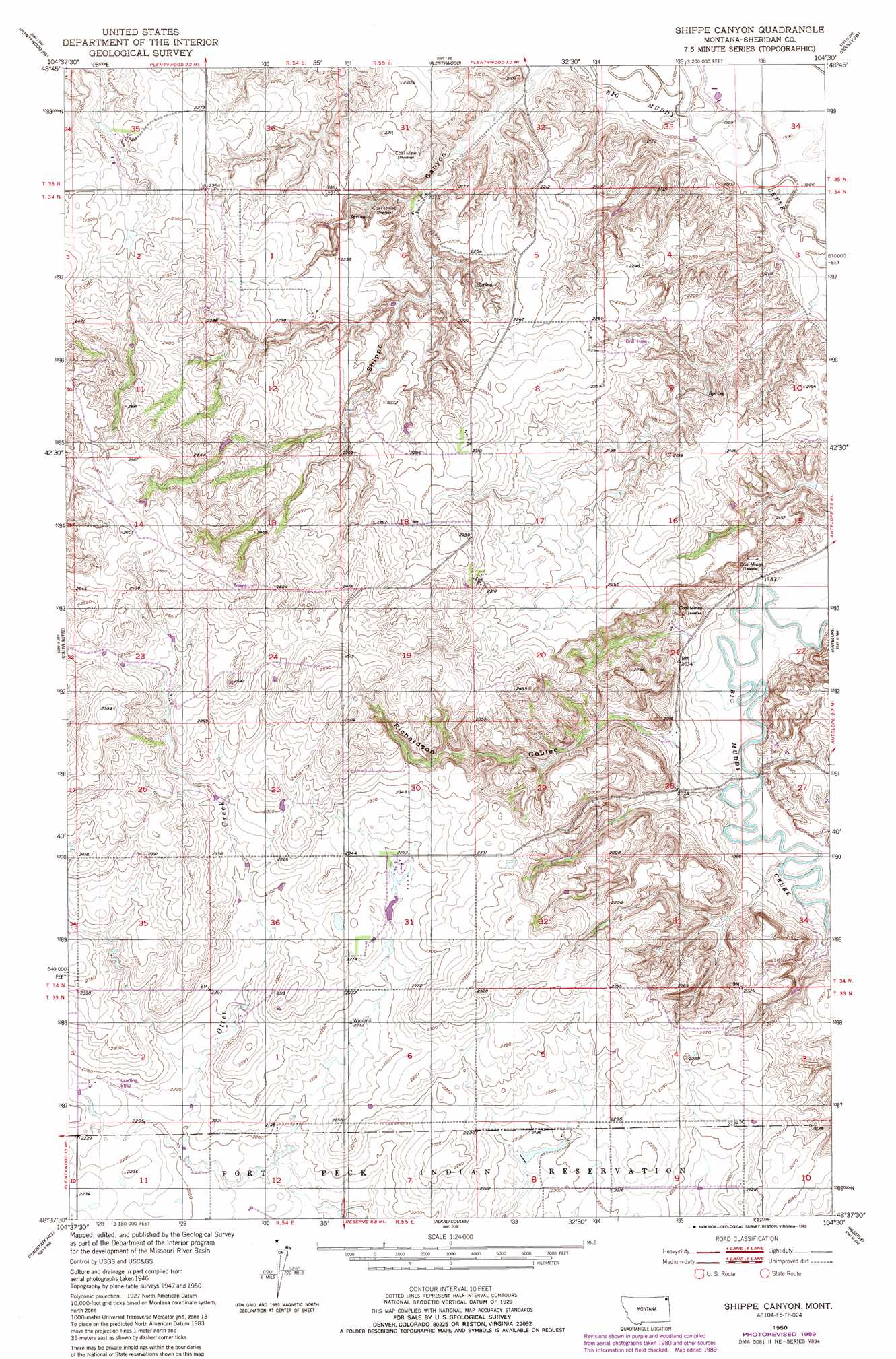
USGS Topo Quad 48104f5 - 1:24,000 scale
| Topo Map Name: | Shippe Canyon |
| USGS Topo Quad ID: | 48104f5 |
| Print Size: | ca. 21 1/4" wide x 27" high |
| Southeast Coordinates: | 48.625° N latitude / 104.5° W longitude |
| Map Center Coordinates: | 48.6875° N latitude / 104.5625° W longitude |
| U.S. State: | MT |
| Filename: | o48104f5.jpg |
| Download Map JPG Image: | Shippe Canyon topo map 1:24,000 scale |
| Map Type: | Topographic |
| Topo Series: | 7.5´ |
| Map Scale: | 1:24,000 |
| Source of Map Images: | United States Geological Survey (USGS) |
| Alternate Map Versions: |
Shippe Canyon MT 1950, updated 1952 Download PDF Buy paper map Shippe Canyon MT 1950, updated 1989 Download PDF Buy paper map Shippe Canyon MT 2011 Download PDF Buy paper map Shippe Canyon MT 2014 Download PDF Buy paper map |
1:24,000 Topo Quads surrounding Shippe Canyon
Outlook |
Plentywood Nw |
Raymond |
Dooley |
Park Lake |
Archer |
Plentywood Sw |
Plentywood |
Dooley Sw |
Dooley Se |
Soo Ne |
Kisler Butte |
Shippe Canyon |
Antelope |
Reserve Ne |
Thornwood Ranch |
Flagstaff Hill |
Alkali Coulee |
Reserve |
Reserve Se |
Smoke Creek Ne |
Homestead Nw |
Homestead |
Medicine Lake |
Capeneys Lake |
> Back to 48104e1 at 1:100,000 scale
> Back to 48104a1 at 1:250,000 scale
> Back to U.S. Topo Maps home
Shippe Canyon topo map: Gazetteer
Shippe Canyon: Dams
Cornhuskers Dam elevation 675m 2214′Plentywood Sewage Lagoon Dam elevation 610m 2001′
Shippe Canyon: Streams
Boxelder Creek elevation 606m 1988′Shippe Canyon: Valleys
Richardson Coulee elevation 615m 2017′Shippe Canyon elevation 612m 2007′
Shippe Canyon: Wells
33N54E01BBDD01 Well elevation 687m 2253′33N54E01BBDD01 Well elevation 689m 2260′
33N54E02DDCD01 Well elevation 672m 2204′
34N54E25CBBB01 Well elevation 713m 2339′
34N55E30BDAA01 Well elevation 722m 2368′
Shippe Canyon digital topo map on disk
Buy this Shippe Canyon topo map showing relief, roads, GPS coordinates and other geographical features, as a high-resolution digital map file on DVD:
Eastern Montana & Western North Dakota
Buy digital topo maps: Eastern Montana & Western North Dakota