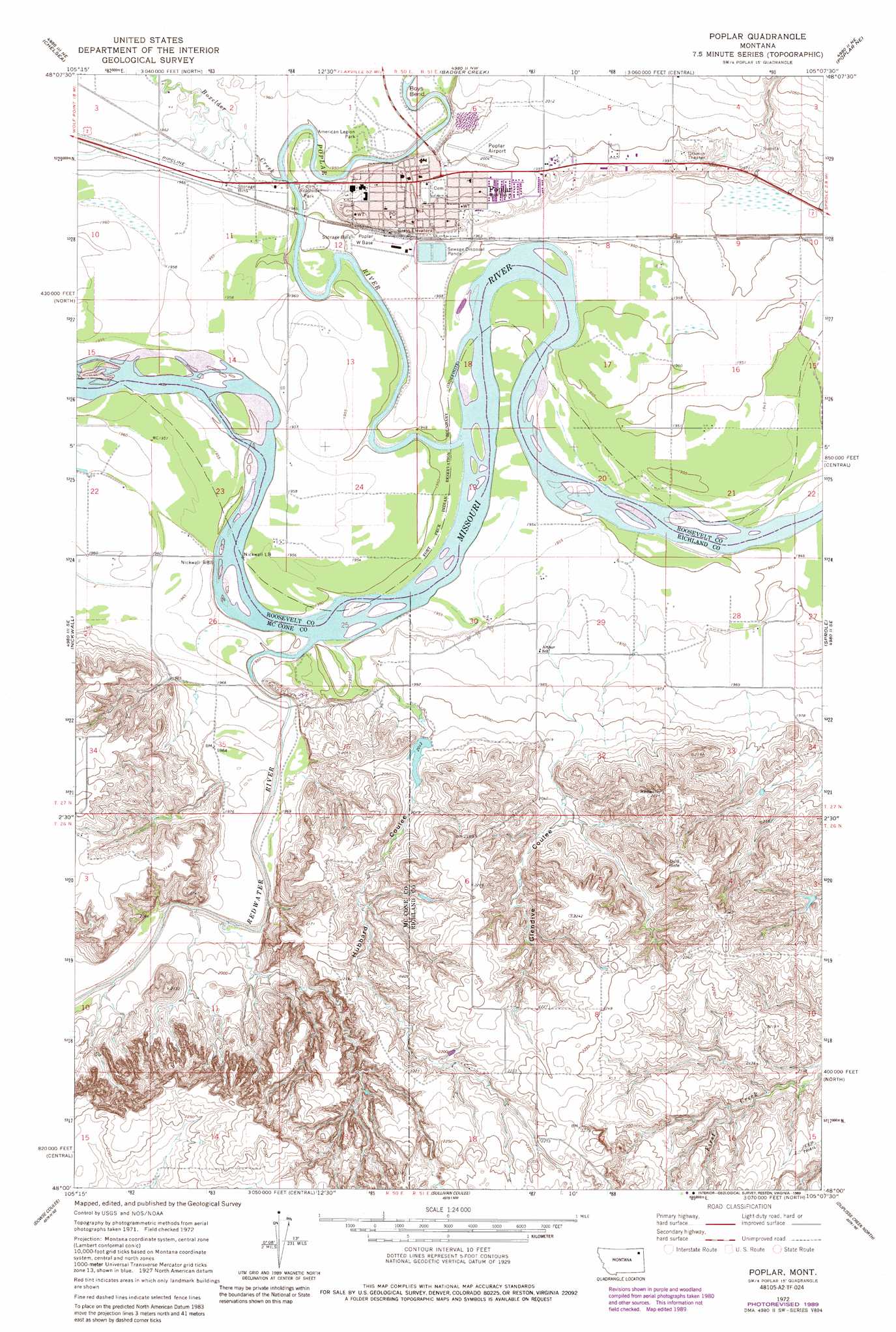
Poplar Topo Map Montana
To zoom in, hover over the map of Poplar
USGS Topo Quad 48105a2 - 1:24,000 scale
| Topo Map Name: | Poplar |
| USGS Topo Quad ID: | 48105a2 |
| Print Size: | ca. 21 1/4" wide x 27" high |
| Southeast Coordinates: | 48° N latitude / 105.125° W longitude |
| Map Center Coordinates: | 48.0625° N latitude / 105.1875° W longitude |
| U.S. State: | MT |
| Filename: | o48105a2.jpg |
| Download Map JPG Image: | Poplar topo map 1:24,000 scale |
| Map Type: | Topographic |
| Topo Series: | 7.5´ |
| Map Scale: | 1:24,000 |
| Source of Map Images: | United States Geological Survey (USGS) |
| Alternate Map Versions: |
Poplar MT 1972, updated 1975 Download PDF Buy paper map Poplar MT 1972, updated 1989 Download PDF Buy paper map Poplar MT 2011 Download PDF Buy paper map Poplar MT 2014 Download PDF Buy paper map |
1:24,000 Topo Quads surrounding Poplar
Sims Spring |
Long Creek West |
Long Creek East |
Geddart Lake |
Smoke Creek Sw |
Chelsea Nw |
Chelsea |
Badger Creek |
Poplar Ne |
Brockton |
Chelsea Sw |
Nickwall |
Poplar |
Sprole |
Mortarstone Bluff |
Gady Coulee |
Dowse Coulee |
Sullivan Coulee |
Duplisse Creek North |
Elmdale Nw |
Vida |
Kraut Coulee |
Lisk Creek |
Duplisse Creek South |
Elmdale Sw |
> Back to 48105a1 at 1:100,000 scale
> Back to 48104a1 at 1:250,000 scale
> Back to U.S. Topo Maps home
Poplar topo map: Gazetteer
Poplar: Airports
Poplar Airport elevation 611m 2004′Poplar: Bends
Boys Bend elevation 592m 1942′Poplar: Bridges
West Poplar River Bridge elevation 592m 1942′Poplar: Dams
Poplar Sewage Disposal Pond Dam elevation 596m 1955′Voorhees Dam elevation 614m 2014′
Poplar: Parks
American Legion Park elevation 596m 1955′Fort Peck Indian Reservation Historical Marker elevation 607m 1991′
Poplar: Populated Places
Arthur (historical) elevation 602m 1975′Poplar elevation 607m 1991′
Poplar: Post Offices
Arthur Post Office (historical) elevation 602m 1975′Poplar Post Office elevation 607m 1991′
Poplar: Streams
Boxelder Creek elevation 593m 1945′Poplar River elevation 592m 1942′
Redwater River elevation 593m 1945′
Poplar: Valleys
Glendive Coulee elevation 612m 2007′Hubbard Coulee elevation 609m 1998′
Poplar: Wells
27N50E01DC__01 Well elevation 596m 1955′27N50E01DD__01 Well elevation 596m 1955′
27N50E02CB__01 Well elevation 598m 1961′
27N50E02DC__01 Well elevation 598m 1961′
27N50E02DC__02 Well elevation 598m 1961′
27N50E03DB__01 Well elevation 599m 1965′
27N50E10AB__01 Well elevation 598m 1961′
27N50E11AA__01 Well elevation 596m 1955′
27N50E11AB__01 Well elevation 598m 1961′
27N50E11BB__01 Well elevation 598m 1961′
27N50E11BB__02 Well elevation 598m 1961′
27N50E11DA__01 Well elevation 597m 1958′
27N50E11DB__01 Well elevation 597m 1958′
27N50E11DD__01 Well elevation 596m 1955′
27N50E12AB__01 Well elevation 606m 1988′
27N50E12AB__02 Well elevation 606m 1988′
27N50E12AC__01 Well elevation 606m 1988′
27N50E12AD__01 Well elevation 606m 1988′
27N50E12AD__02 Well elevation 606m 1988′
27N50E12BB__01 Well elevation 597m 1958′
27N50E12CCBC01 Well elevation 597m 1958′
27N50E13BD__01 Well elevation 596m 1955′
27N50E14DDAA01 Well elevation 598m 1961′
27N50E22AC__01 Well elevation 598m 1961′
27N50E23CD__01 Well elevation 596m 1955′
27N50E23DD__01 Well elevation 596m 1955′
27N50E24BC__01 Well elevation 596m 1955′
27N50E24BC__02 Well elevation 596m 1955′
27N50E24BC__03 Well elevation 596m 1955′
27N50E25BD__01 Well elevation 593m 1945′
27N50E25BD__02 Well elevation 593m 1945′
27N50E25DC__01 Well elevation 600m 1968′
27N50E26BA__01 Well elevation 601m 1971′
27N50E27AB__01 Well elevation 598m 1961′
27N50E27AB__02 Well elevation 598m 1961′
27N50E35BA__01 Well elevation 601m 1971′
27N51E04BC__01 Well elevation 618m 2027′
27N51E04CCAA01 Well elevation 608m 1994′
27N51E04CDDD01 Well elevation 604m 1981′
27N51E05CC__01 Well elevation 611m 2004′
27N51E05DB__01 Well elevation 613m 2011′
27N51E07AD__01 Well elevation 601m 1971′
27N51E07BD__01 Well elevation 605m 1984′
27N51E07BD__02 Well elevation 605m 1984′
27N51E07BD__05 Well elevation 605m 1984′
27N51E07DB__03 Well elevation 595m 1952′
27N51E07DB__04 Well elevation 595m 1952′
27N51E08CA__01 Well elevation 595m 1952′
27N51E08CA__02 Well elevation 595m 1952′
27N51E08CA__03 Well elevation 595m 1952′
27N51E08CA__04 Well elevation 595m 1952′
27N51E08DDD_01 Well elevation 595m 1952′
27N51E09CA__01 Well elevation 595m 1952′
27N51E09CC__01 Well elevation 596m 1955′
27N51E10BC__01 Well elevation 595m 1952′
27N51E15BB__01 Well elevation 591m 1938′
27N51E16CD__01 Well elevation 595m 1952′
27N51E16CD__02 Well elevation 595m 1952′
27N51E17DC__01 Well elevation 595m 1952′
27N51E17DC__02 Well elevation 595m 1952′
27N51E18BC__01 Well elevation 597m 1958′
27N51E18BC__02 Well elevation 597m 1958′
27N51E19AD__01 Well elevation 591m 1938′
27N51E21BB__01 Well elevation 595m 1952′
27N51E27BC__01 Well elevation 593m 1945′
27N51E27CB__01 Well elevation 596m 1955′
27N51E27CBBB01 Well elevation 597m 1958′
27N51E28CA__01 Well elevation 597m 1958′
27N51E28DB__01 Well elevation 598m 1961′
27N51E28DB__02 Well elevation 598m 1961′
27N51E28DB__03 Well elevation 598m 1961′
27N51E29AB__01 Well elevation 596m 1955′
27N51E29BB__01 Well elevation 597m 1958′
27N51E29BBCB01 Well elevation 597m 1958′
27N51E29BC__01 Well elevation 598m 1961′
27N51E29BD__01 Well elevation 598m 1961′
27N51E30AC__01 Well elevation 597m 1958′
27N51E30AD__01 Well elevation 598m 1961′
27N51E30AD__02 Well elevation 598m 1961′
27N51E32BA__01 Well elevation 606m 1988′
Poplar digital topo map on disk
Buy this Poplar topo map showing relief, roads, GPS coordinates and other geographical features, as a high-resolution digital map file on DVD:
Eastern Montana & Western North Dakota
Buy digital topo maps: Eastern Montana & Western North Dakota