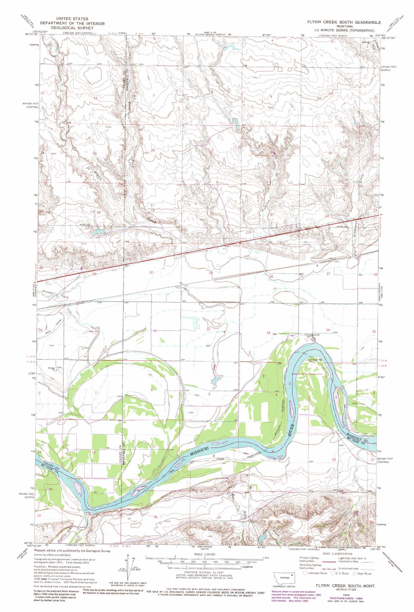
Flynn Creek South Topo Map Montana
To zoom in, hover over the map of Flynn Creek South
USGS Topo Quad 48105a7 - 1:24,000 scale
| Topo Map Name: | Flynn Creek South |
| USGS Topo Quad ID: | 48105a7 |
| Print Size: | ca. 21 1/4" wide x 27" high |
| Southeast Coordinates: | 48° N latitude / 105.75° W longitude |
| Map Center Coordinates: | 48.0625° N latitude / 105.8125° W longitude |
| U.S. State: | MT |
| Filename: | o48105a7.jpg |
| Download Map JPG Image: | Flynn Creek South topo map 1:24,000 scale |
| Map Type: | Topographic |
| Topo Series: | 7.5´ |
| Map Scale: | 1:24,000 |
| Source of Map Images: | United States Geological Survey (USGS) |
| Alternate Map Versions: |
Flynn Creek South MT 1972, updated 1975 Download PDF Buy paper map Flynn Creek South MT 1972, updated 1989 Download PDF Buy paper map Flynn Creek South MT 2011 Download PDF Buy paper map Flynn Creek South MT 2014 Download PDF Buy paper map |
1:24,000 Topo Quads surrounding Flynn Creek South
Hauck Coulee |
Todd Lakes |
Todd Lakes Se |
Tule Valley West |
Tule Valley East |
Dubbe Reservoir |
Oswego Nw |
Flynn Creek North |
Wolf Point Nw |
Wolf Point Ne |
Frazer |
Oswego |
Flynn Creek South |
Wolf Point |
Macon |
Pasture Creek |
Turtle Creek |
Emily Coulee |
Antelope Creek Res. |
Rock Creek |
Willis Buttes |
Shade Creek |
Sadie Coulee |
Dailey Spring |
Lone Pine School |
> Back to 48105a1 at 1:100,000 scale
> Back to 48104a1 at 1:250,000 scale
> Back to U.S. Topo Maps home
Flynn Creek South topo map: Gazetteer
Flynn Creek South: Dams
Gass Reservoir Dam elevation 622m 2040′Warmbrod Dam elevation 679m 2227′
Flynn Creek South: Populated Places
Pearmond (historical) elevation 606m 1988′Flynn Creek South: Post Offices
Pearmond Post Office (historical) elevation 606m 1988′Flynn Creek South: Streams
Box Elder Creek elevation 610m 2001′East Fork Flynn Creek elevation 627m 2057′
Flynn Creek elevation 610m 2001′
Oswego Creek elevation 611m 2004′
Prairie Elk Creek elevation 606m 1988′
Flynn Creek South: Valleys
Spring Coulee elevation 607m 1991′Steele Coulee elevation 611m 2004′
Flynn Creek South: Wells
26N45E01AB__01 Well elevation 610m 2001′26N45E01BB__01 Well elevation 614m 2014′
26N45E01CB__01 Well elevation 610m 2001′
26N45E01CC__01 Well elevation 610m 2001′
26N45E01CD__01 Well elevation 610m 2001′
26N45E02AC__01 Well elevation 612m 2007′
26N45E02AD__01 Well elevation 616m 2020′
26N45E11AC__01 Well elevation 610m 2001′
26N45E11DCCD01 Well elevation 610m 2001′
26N46E02BB__01 Well elevation 609m 1998′
26N46E03CDDC01 Well elevation 608m 1994′
26N46E05DB__01 Well elevation 610m 2001′
26N46E05DD__01 Well elevation 609m 1998′
26N46E06CA__01 Well elevation 610m 2001′
26N46E09CC__01 Well elevation 622m 2040′
26N46E10BA__01 Well elevation 610m 2001′
26N46E10BB__01 Well elevation 610m 2001′
26N46E10CA__01 Well elevation 614m 2014′
26N46E14CB__01 Well elevation 669m 2194′
26N46E18CD__01 Well elevation 638m 2093′
27N45E36BB__01 Well elevation 616m 2020′
27N45E36BCC_01 Well elevation 615m 2017′
27N45E36CCCC01 Well elevation 615m 2017′
27N45E36DC__01 Well elevation 610m 2001′
27N46E07BB__01 Well elevation 671m 2201′
27N46E20CD__01 Well elevation 626m 2053′
27N46E26BC__01 Well elevation 610m 2001′
27N46E26CD__01 Well elevation 609m 1998′
27N46E27AD__01 Well elevation 610m 2001′
27N46E27CB__01 Well elevation 610m 2001′
27N46E28BA__01 Well elevation 620m 2034′
27N46E28BB__01 Well elevation 613m 2011′
27N46E28DA__01 Well elevation 611m 2004′
27N46E28DA__02 Well elevation 611m 2004′
27N46E30AADB01 Well elevation 617m 2024′
27N46E30DD__01 Well elevation 611m 2004′
27N46E31BA__01 Well elevation 611m 2004′
27N46E31BB__01 Well elevation 611m 2004′
27N46E31CB__01 Well elevation 610m 2001′
27N46E32BBA_01 Well elevation 610m 2001′
27N46E32BC__01 Well elevation 611m 2004′
27N46E33AA__01 Well elevation 610m 2001′
27N46E33BA__01 Well elevation 610m 2001′
27N46E33CA__01 Well elevation 610m 2001′
27N46E34CA__01 Well elevation 608m 1994′
Flynn Creek South digital topo map on disk
Buy this Flynn Creek South topo map showing relief, roads, GPS coordinates and other geographical features, as a high-resolution digital map file on DVD:
Eastern Montana & Western North Dakota
Buy digital topo maps: Eastern Montana & Western North Dakota