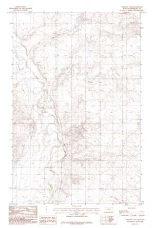
Geddart Lake Topo Map Montana
To zoom in, hover over the map of Geddart Lake
USGS Topo Quad 48105c1 - 1:24,000 scale
| Topo Map Name: | Geddart Lake |
| USGS Topo Quad ID: | 48105c1 |
| Print Size: | ca. 21 1/4" wide x 27" high |
| Southeast Coordinates: | 48.25° N latitude / 105° W longitude |
| Map Center Coordinates: | 48.3125° N latitude / 105.0625° W longitude |
| U.S. State: | MT |
| Filename: | o48105c1.jpg |
| Download Map JPG Image: | Geddart Lake topo map 1:24,000 scale |
| Map Type: | Topographic |
| Topo Series: | 7.5´ |
| Map Scale: | 1:24,000 |
| Source of Map Images: | United States Geological Survey (USGS) |
| Alternate Map Versions: |
Geddart Lake MT 1983, updated 1985 Download PDF Buy paper map Geddart Lake MT 2011 Download PDF Buy paper map Geddart Lake MT 2014 Download PDF Buy paper map |
1:24,000 Topo Quads surrounding Geddart Lake
> Back to 48105a1 at 1:100,000 scale
> Back to 48104a1 at 1:250,000 scale
> Back to U.S. Topo Maps home
Geddart Lake topo map: Gazetteer
Geddart Lake: Dams
Graninger Dam elevation 670m 2198′Geddart Lake: Lakes
Geddart Lake elevation 655m 2148′Geddart Lake: Valleys
Kirns Coulee elevation 632m 2073′Slims Coulee elevation 623m 2043′
Geddart Lake: Wells
29N51E03BCDB01 Well elevation 629m 2063′29N51E03CAAD01 Well elevation 653m 2142′
29N51E03CABA01 Well elevation 634m 2080′
29N51E08CC__01 Well elevation 642m 2106′
29N51E09ABBA01 Well elevation 621m 2037′
29N51E09ABBA02 Well elevation 621m 2037′
29N51E09ABBA03 Well elevation 621m 2037′
29N51E09ABBA04 Well elevation 621m 2037′
29N51E09CA__01 Well elevation 621m 2037′
29N51E10CADD01 Well elevation 633m 2076′
29N51E10CDAA01 Well elevation 631m 2070′
29N51E10CDAB01 Well elevation 632m 2073′
29N51E10CDBA01 Well elevation 630m 2066′
29N51E14ACCC01 Well elevation 667m 2188′
29N51E14BDDA01 Well elevation 668m 2191′
29N51E15CACA01 Well elevation 630m 2066′
29N51E15CCBD01 Well elevation 622m 2040′
29N51E16BDAA01 Well elevation 618m 2027′
29N51E16CBCC01 Well elevation 619m 2030′
29N51E16CCAA01 Well elevation 618m 2027′
29N51E16DACA01 Well elevation 615m 2017′
29N51E16DDDD01 Well elevation 619m 2030′
29N51E20ABBA01 Well elevation 622m 2040′
29N51E20ABBA02 Well elevation 622m 2040′
29N51E20DABB01 Well elevation 616m 2020′
29N51E21ABCB01 Well elevation 616m 2020′
29N51E21ABCC01 Well elevation 616m 2020′
29N51E21ABDA01 Well elevation 615m 2017′
29N51E21BBAA01 Well elevation 618m 2027′
30N51E10CCAD01 Well elevation 661m 2168′
30N51E13DCBC01 Well elevation 690m 2263′
30N51E28DCAA01 Well elevation 656m 2152′
Geddart Lake digital topo map on disk
Buy this Geddart Lake topo map showing relief, roads, GPS coordinates and other geographical features, as a high-resolution digital map file on DVD:
Eastern Montana & Western North Dakota
Buy digital topo maps: Eastern Montana & Western North Dakota


