Todd Lakes Topo Map Montana
To zoom in, hover over the map of Todd Lakes
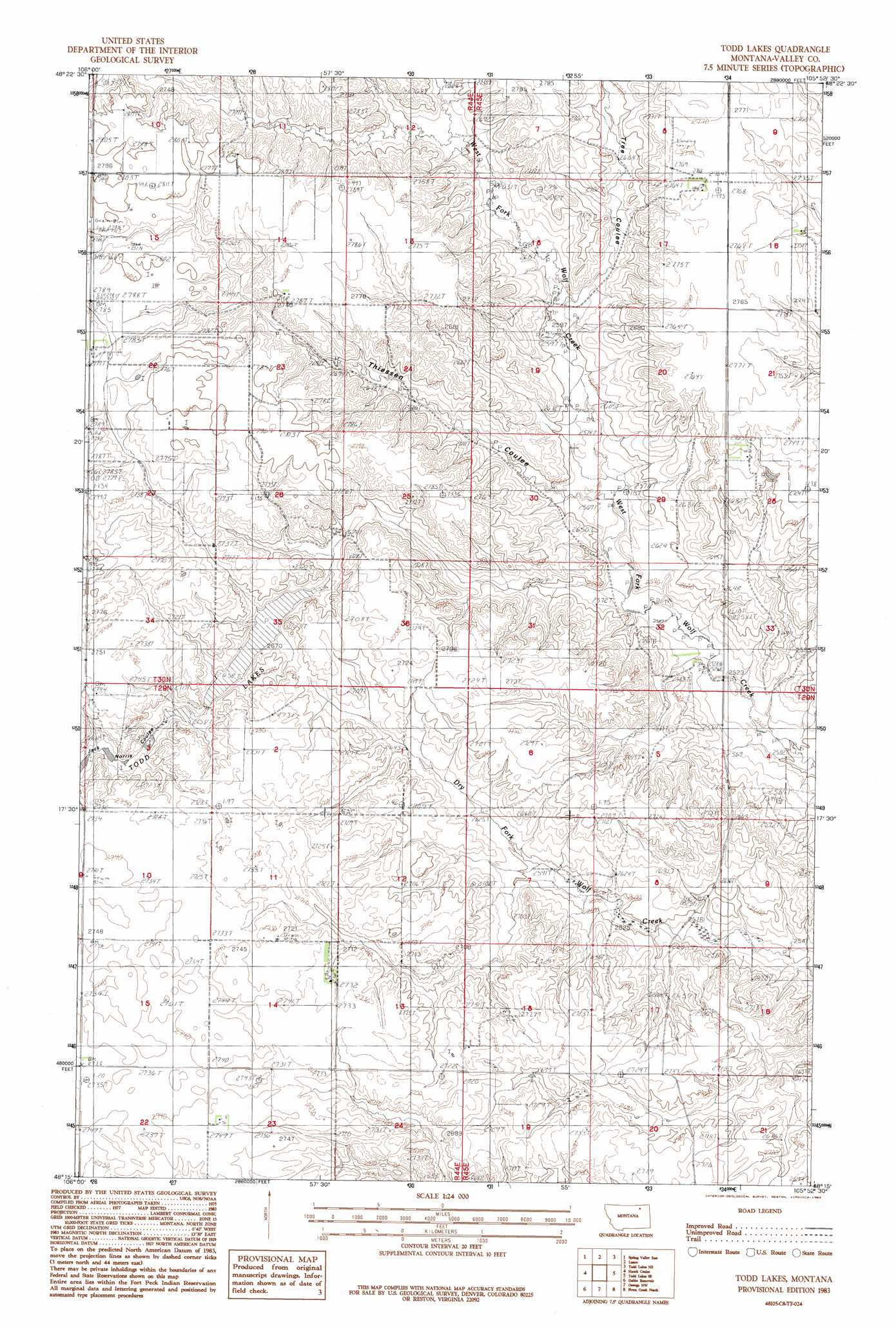
USGS Topo Quad 48105c8 - 1:24,000 scale
| Topo Map Name: | Todd Lakes |
| USGS Topo Quad ID: | 48105c8 |
| Print Size: | ca. 21 1/4" wide x 27" high |
| Southeast Coordinates: | 48.25° N latitude / 105.875° W longitude |
| Map Center Coordinates: | 48.3125° N latitude / 105.9375° W longitude |
| U.S. State: | MT |
| Filename: | o48105c8.jpg |
| Download Map JPG Image: | Todd Lakes topo map 1:24,000 scale |
| Map Type: | Topographic |
| Topo Series: | 7.5´ |
| Map Scale: | 1:24,000 |
| Source of Map Images: | United States Geological Survey (USGS) |
| Alternate Map Versions: |
Todd Lakes MT 1983, updated 1983 Download PDF Buy paper map Todd Lakes MT 1983, updated 1983 Download PDF Buy paper map Todd Lakes MT 2011 Download PDF Buy paper map Todd Lakes MT 2014 Download PDF Buy paper map |
1:24,000 Topo Quads surrounding Todd Lakes
Larslan |
Blink Springs |
Haugens Hill |
Poplar Coulee |
Peerless 4 Sw |
Spring Valley West |
Spring Valley East |
Lustre |
Todd Lakes Ne |
Volt |
Spring Creek Sw |
Hauck Coulee |
Todd Lakes |
Todd Lakes Se |
Tule Valley West |
Milk River Coulee |
Dubbe Reservoir |
Oswego Nw |
Flynn Creek North |
Wolf Point Nw |
Kintyre |
Frazer |
Oswego |
Flynn Creek South |
Wolf Point |
> Back to 48105a1 at 1:100,000 scale
> Back to 48104a1 at 1:250,000 scale
> Back to U.S. Topo Maps home
Todd Lakes topo map: Gazetteer
Todd Lakes: Airports
Zerbe Airport elevation 833m 2732′Todd Lakes: Dams
Todd Lake Dam elevation 814m 2670′Todd Lakes: Lakes
Todd Lakes elevation 811m 2660′Todd Lakes: Populated Places
Bakers (historical) elevation 807m 2647′Todd Lakes: Reservoirs
Todd Lake elevation 814m 2670′Todd Lakes: Valleys
Thiessen Coulee elevation 782m 2565′Tree Coulee elevation 793m 2601′
Todd Lakes: Wells
29N44E03BBCA01 Well elevation 837m 2746′29N44E03BBCD01 Well elevation 833m 2732′
29N44E14ADAB01 Well elevation 831m 2726′
29N44E23BCCA01 Well elevation 838m 2749′
29N44E23BCCD01 Well elevation 838m 2749′
29N44E24ABBA01 Well elevation 828m 2716′
29N45E18CCBB01 Well elevation 834m 2736′
30N44E11CCAB01 Well elevation 850m 2788′
30N44E22BCBC01 Well elevation 850m 2788′
30N45E16ACBD01 Well elevation 838m 2749′
30N45E17AABB01 Well elevation 845m 2772′
30N45E28BBDA02 Well elevation 831m 2726′
30N45E28BBDB01 Well elevation 834m 2736′
Todd Lakes digital topo map on disk
Buy this Todd Lakes topo map showing relief, roads, GPS coordinates and other geographical features, as a high-resolution digital map file on DVD:
Eastern Montana & Western North Dakota
Buy digital topo maps: Eastern Montana & Western North Dakota