Reed Springs Topo Map Montana
To zoom in, hover over the map of Reed Springs
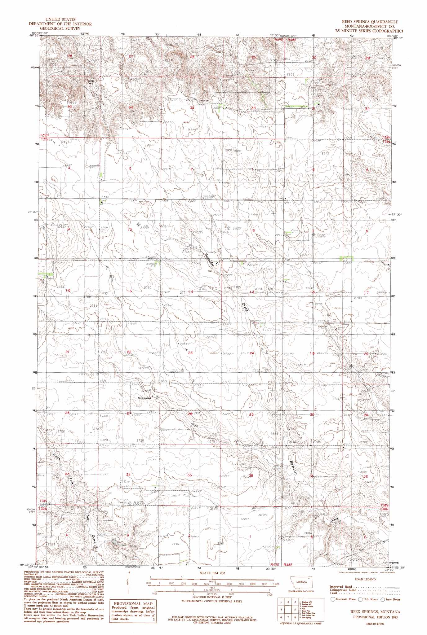
USGS Topo Quad 48105d5 - 1:24,000 scale
| Topo Map Name: | Reed Springs |
| USGS Topo Quad ID: | 48105d5 |
| Print Size: | ca. 21 1/4" wide x 27" high |
| Southeast Coordinates: | 48.375° N latitude / 105.5° W longitude |
| Map Center Coordinates: | 48.4375° N latitude / 105.5625° W longitude |
| U.S. State: | MT |
| Filename: | o48105d5.jpg |
| Download Map JPG Image: | Reed Springs topo map 1:24,000 scale |
| Map Type: | Topographic |
| Topo Series: | 7.5´ |
| Map Scale: | 1:24,000 |
| Source of Map Images: | United States Geological Survey (USGS) |
| Alternate Map Versions: |
Reed Springs MT 1983, updated 1983 Download PDF Buy paper map Reed Springs MT 2011 Download PDF Buy paper map Reed Springs MT 2014 Download PDF Buy paper map |
1:24,000 Topo Quads surrounding Reed Springs
West Fork Ne |
Peerless 4 Nw |
Peerless 4 Ne |
Cabarett Coulee |
Line Coulee |
Poplar Coulee |
Peerless 4 Sw |
Peerless 4 Se |
Nielsen Coulee |
Bredette |
Todd Lakes Ne |
Volt |
Reed Springs |
Bears Nest |
Windy Butte |
Todd Lakes Se |
Tule Valley West |
Tule Valley East |
Sims Spring |
Long Creek West |
Flynn Creek North |
Wolf Point Nw |
Wolf Point Ne |
Chelsea Nw |
Chelsea |
> Back to 48105a1 at 1:100,000 scale
> Back to 48104a1 at 1:250,000 scale
> Back to U.S. Topo Maps home
Reed Springs topo map: Gazetteer
Reed Springs: Populated Places
Benrud (historical) elevation 838m 2749′Reed Springs: Post Offices
Benrud Post Office (historical) elevation 838m 2749′Reed Springs: Springs
32N47E25CDBD01 Spring elevation 834m 2736′Reed Springs elevation 820m 2690′
Reed Springs: Summits
Castle Rock elevation 837m 2746′Reed Springs: Wells
31N47E02DADD01 Well elevation 855m 2805′31N47E14AAAC01 Well elevation 839m 2752′
31N47E16BCAA01 Well elevation 858m 2814′
31N47E16BCAA02 Well elevation 858m 2814′
31N47E33AC__01 Well elevation 821m 2693′
31N48E07CBAC01 Well elevation 839m 2752′
31N48E07CBBA01 Well elevation 839m 2752′
31N48E17ABAA01 Well elevation 828m 2716′
31N48E18BCBC01 Well elevation 835m 2739′
31N48E30CBCD01 Well elevation 808m 2650′
31N48E31DCCC01 Well elevation 800m 2624′
Reed Springs digital topo map on disk
Buy this Reed Springs topo map showing relief, roads, GPS coordinates and other geographical features, as a high-resolution digital map file on DVD:
Eastern Montana & Western North Dakota
Buy digital topo maps: Eastern Montana & Western North Dakota