Lustre Topo Map Montana
To zoom in, hover over the map of Lustre
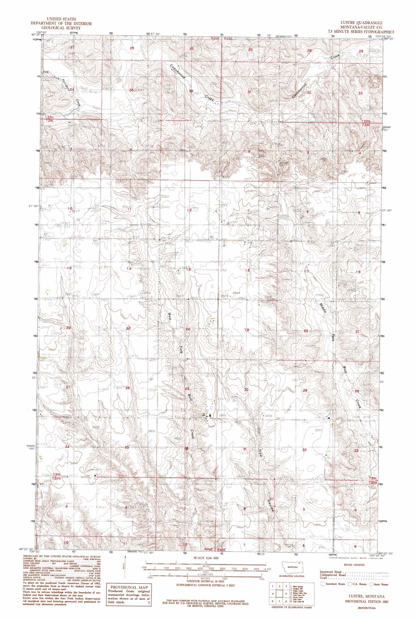
USGS Topo Quad 48105d8 - 1:24,000 scale
| Topo Map Name: | Lustre |
| USGS Topo Quad ID: | 48105d8 |
| Print Size: | ca. 21 1/4" wide x 27" high |
| Southeast Coordinates: | 48.375° N latitude / 105.875° W longitude |
| Map Center Coordinates: | 48.4375° N latitude / 105.9375° W longitude |
| U.S. State: | MT |
| Filename: | o48105d8.jpg |
| Download Map JPG Image: | Lustre topo map 1:24,000 scale |
| Map Type: | Topographic |
| Topo Series: | 7.5´ |
| Map Scale: | 1:24,000 |
| Source of Map Images: | United States Geological Survey (USGS) |
| Alternate Map Versions: |
Lustre MT 1983, updated 1983 Download PDF Buy paper map Lustre MT 2011 Download PDF Buy paper map Lustre MT 2014 Download PDF Buy paper map |
1:24,000 Topo Quads surrounding Lustre
Larslan Nw |
Johnnys Hill |
West Fork |
West Fork Ne |
Peerless 4 Nw |
Larslan |
Blink Springs |
Haugens Hill |
Poplar Coulee |
Peerless 4 Sw |
Spring Valley West |
Spring Valley East |
Lustre |
Todd Lakes Ne |
Volt |
Spring Creek Sw |
Hauck Coulee |
Todd Lakes |
Todd Lakes Se |
Tule Valley West |
Milk River Coulee |
Dubbe Reservoir |
Oswego Nw |
Flynn Creek North |
Wolf Point Nw |
> Back to 48105a1 at 1:100,000 scale
> Back to 48104a1 at 1:250,000 scale
> Back to U.S. Topo Maps home
Lustre topo map: Gazetteer
Lustre: Populated Places
Lustre elevation 832m 2729′Lustre: Post Offices
Lustre Post Office (historical) elevation 867m 2844′Lustre: Springs
31N45E16CBDB01 Spring elevation 870m 2854′Lustre: Wells
30N44E03CBBB01 Well elevation 866m 2841′30N44E03CDAC01 Well elevation 845m 2772′
30N44E11CADA01 Well elevation 852m 2795′
30N45E04CCAD01 Well elevation 851m 2791′
31N44E10BCDC01 Well elevation 896m 2939′
31N44E12ADDC01 Well elevation 891m 2923′
31N44E12DAAB01 Well elevation 891m 2923′
31N44E13CABA01 Well elevation 888m 2913′
31N44E15BADB01 Well elevation 891m 2923′
31N44E24ADAC01 Well elevation 888m 2913′
31N44E27CCCC01 Well elevation 875m 2870′
31N44E34BABA01 Well elevation 870m 2854′
31N45E08DCCC01 Well elevation 867m 2844′
31N45E18ABBA01 Well elevation 891m 2923′
31N45E18BAAA01 Well elevation 894m 2933′
31N45E18BBBD01 Well elevation 893m 2929′
31N45E29DDCA01 Well elevation 867m 2844′
31N45E32AAAD01 Well elevation 867m 2844′
31N45E32DADB01 Well elevation 866m 2841′
Lustre digital topo map on disk
Buy this Lustre topo map showing relief, roads, GPS coordinates and other geographical features, as a high-resolution digital map file on DVD:
Eastern Montana & Western North Dakota
Buy digital topo maps: Eastern Montana & Western North Dakota