Scobey Topo Map Montana
To zoom in, hover over the map of Scobey
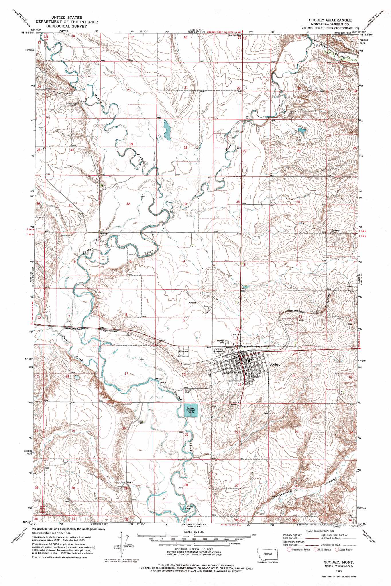
USGS Topo Quad 48105g4 - 1:24,000 scale
| Topo Map Name: | Scobey |
| USGS Topo Quad ID: | 48105g4 |
| Print Size: | ca. 21 1/4" wide x 27" high |
| Southeast Coordinates: | 48.75° N latitude / 105.375° W longitude |
| Map Center Coordinates: | 48.8125° N latitude / 105.4375° W longitude |
| U.S. State: | MT |
| Filename: | o48105g4.jpg |
| Download Map JPG Image: | Scobey topo map 1:24,000 scale |
| Map Type: | Topographic |
| Topo Series: | 7.5´ |
| Map Scale: | 1:24,000 |
| Source of Map Images: | United States Geological Survey (USGS) |
| Alternate Map Versions: |
Scobey MT 1973, updated 1976 Download PDF Buy paper map Scobey MT 2011 Download PDF Buy paper map Scobey MT 2014 Download PDF Buy paper map |
1:24,000 Topo Quads surrounding Scobey
Four Buttes Nw |
Four Buttes Ne |
Scobey Nw |
Si Merrell Slough |
Whitetail |
Killenbeck Reservoir |
Four Buttes |
Scobey |
Madoc |
Flaxville |
Peerless 4 Nw |
Peerless 4 Ne |
Cabarett Coulee |
Line Coulee |
Pleasant Prairie Nw |
Peerless 4 Sw |
Peerless 4 Se |
Nielsen Coulee |
Bredette |
Pleasant Prairie Sw |
> Back to 48105e1 at 1:100,000 scale
> Back to 48104a1 at 1:250,000 scale
> Back to U.S. Topo Maps home
Scobey topo map: Gazetteer
Scobey: Airports
Scobey Airport elevation 735m 2411′Scobey: Dams
Scobey Sewage Disposal Ponds Dam elevation 709m 2326′Scobey: Parks
Plainsmen Field elevation 750m 2460′Roseland Park elevation 754m 2473′
Wood Mountain Trail Historical Marker elevation 752m 2467′
Scobey: Populated Places
Brenna Trailer Court elevation 763m 2503′Leibrands Trailer Court elevation 764m 2506′
Scobey elevation 752m 2467′
Scobey: Post Offices
Daniels Post Office (historical) elevation 717m 2352′Scobey Post Office elevation 756m 2480′
Scobey: Streams
Butte Creek elevation 710m 2329′East Fork Poplar River elevation 716m 2349′
Middle Fork Poplar River elevation 716m 2349′
Scobey: Valleys
Shannon Coulee elevation 731m 2398′Scobey: Wells
35N48E01CCAA01 Well elevation 775m 2542′35N48E04ABCD01 Well elevation 724m 2375′
35N48E05ACAC01 Well elevation 717m 2352′
35N48E07BCCA01 Well elevation 717m 2352′
35N48E07BCCA02 Well elevation 716m 2349′
35N48E07DABA01 Well elevation 714m 2342′
35N48E09ADAD01 Well elevation 741m 2431′
35N48E09CCDC01 Well elevation 738m 2421′
35N48E10BADD01 Well elevation 742m 2434′
35N48E11CBCB01 Well elevation 767m 2516′
35N48E11CBCC01 Well elevation 760m 2493′
35N48E11CDDD01 Well elevation 757m 2483′
35N48E13CDBC01 Well elevation 788m 2585′
35N48E13CDBC02 Well elevation 794m 2604′
35N48E13CDBC03 Well elevation 794m 2604′
35N48E15ABAB01 Well elevation 751m 2463′
35N48E15ADAB01 Well elevation 762m 2500′
35N48E15CDBB01 Well elevation 752m 2467′
35N48E16CBBD01 Well elevation 711m 2332′
35N48E16CBCD01 Well elevation 709m 2326′
35N48E16CBDC01 Well elevation 711m 2332′
35N48E16CDAA01 Well elevation 713m 2339′
35N48E20ABDC01 Well elevation 711m 2332′
35N48E20ACAC01 Well elevation 714m 2342′
35N48E20ACDB01 Well elevation 712m 2335′
35N48E20CAAA01 Well elevation 719m 2358′
35N48E20CAAA03 Well elevation 719m 2358′
35N48E20CAAD__ Well elevation 720m 2362′
35N48E22ABBB01 Well elevation 764m 2506′
35N48E25CCCC01 Well elevation 744m 2440′
35N48E28DAAA01 Well elevation 715m 2345′
35N48E30BAAA01 Well elevation 756m 2480′
35N48E30BAAC01 Well elevation 758m 2486′
35N48E34ABBB01 Well elevation 723m 2372′
36N44E25DDDD01 Well elevation 766m 2513′
36N47E25DAAA01 Well elevation 754m 2473′
36N47E25DAAA02 Well elevation 753m 2470′
36N48E16CBBC01 Well elevation 745m 2444′
36N48E16CBBC02 Well elevation 745m 2444′
36N48E22ACC_01 Well elevation 730m 2395′
36N48E22BAAD01 Well elevation 739m 2424′
36N48E25CCDB01 Well elevation 776m 2545′
36N48E27ABAB01 Well elevation 723m 2372′
36N48E28ACDC01 Well elevation 723m 2372′
36N48E30DADB01 Well elevation 739m 2424′
36N48E31DBD_01 Well elevation 730m 2395′
36N48E32BBCA01 Well elevation 724m 2375′
36N48E32BBCD01 Well elevation 721m 2365′
36N48E32BCBA01 Well elevation 721m 2365′
36N48E33CCCA01 Well elevation 719m 2358′
36N48E35BCCC01 Well elevation 739m 2424′
36N48E35BCCD01 Well elevation 740m 2427′
36N48E35DCCC01 Well elevation 757m 2483′
36N48E35DCCD01 Well elevation 760m 2493′
Scobey digital topo map on disk
Buy this Scobey topo map showing relief, roads, GPS coordinates and other geographical features, as a high-resolution digital map file on DVD:
Eastern Montana & Western North Dakota
Buy digital topo maps: Eastern Montana & Western North Dakota