Horseshoe Basin Topo Map Montana
To zoom in, hover over the map of Horseshoe Basin
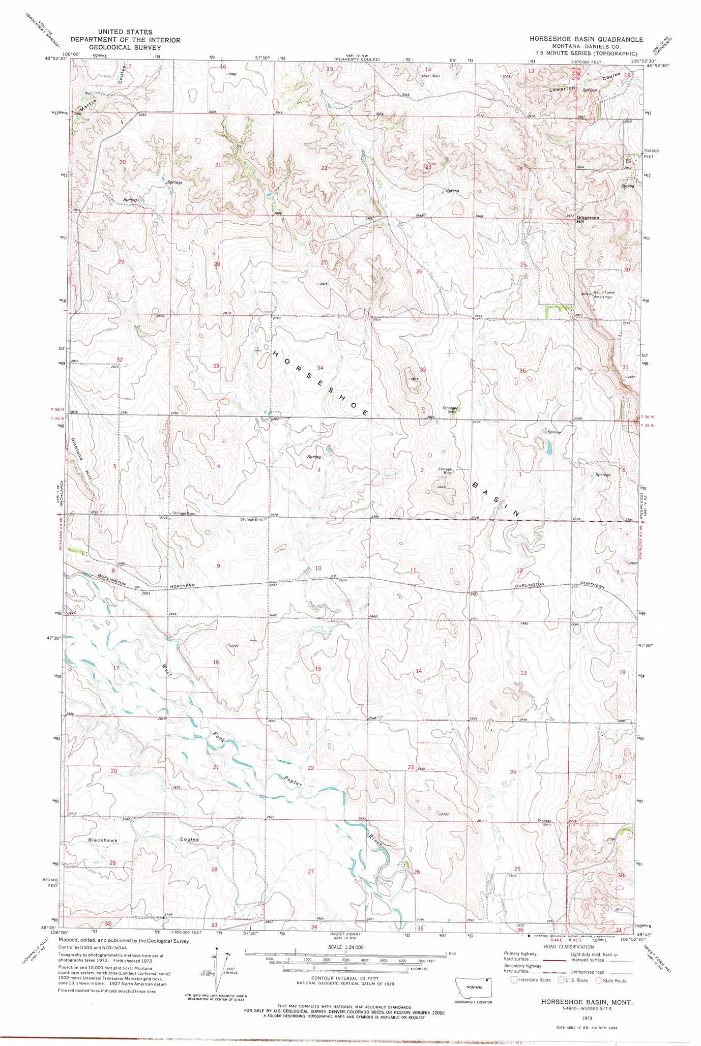
USGS Topo Quad 48105g8 - 1:24,000 scale
| Topo Map Name: | Horseshoe Basin |
| USGS Topo Quad ID: | 48105g8 |
| Print Size: | ca. 21 1/4" wide x 27" high |
| Southeast Coordinates: | 48.75° N latitude / 105.875° W longitude |
| Map Center Coordinates: | 48.8125° N latitude / 105.9375° W longitude |
| U.S. State: | MT |
| Filename: | o48105g8.jpg |
| Download Map JPG Image: | Horseshoe Basin topo map 1:24,000 scale |
| Map Type: | Topographic |
| Topo Series: | 7.5´ |
| Map Scale: | 1:24,000 |
| Source of Map Images: | United States Geological Survey (USGS) |
| Alternate Map Versions: |
Horseshoe Basin MT 1973, updated 1976 Download PDF Buy paper map Horseshoe Basin MT 2011 Download PDF Buy paper map Horseshoe Basin MT 2014 Download PDF Buy paper map |
1:24,000 Topo Quads surrounding Horseshoe Basin
Kaminski Hill |
Brockway Spring |
Flaherty Coulee |
Carbert |
Four Buttes Nw |
Glentana East |
Richland |
Horseshoe Basin |
Peerless |
Killenbeck Reservoir |
Larslan Nw |
Johnnys Hill |
West Fork |
West Fork Ne |
Peerless 4 Nw |
Larslan |
Blink Springs |
Haugens Hill |
Poplar Coulee |
Peerless 4 Sw |
> Back to 48105e1 at 1:100,000 scale
> Back to 48104a1 at 1:250,000 scale
> Back to U.S. Topo Maps home
Horseshoe Basin topo map: Gazetteer
Horseshoe Basin: Basins
Horseshoe Basin elevation 830m 2723′Horseshoe Basin: Summits
Gregerson Hill elevation 908m 2979′Horseshoe Basin: Valleys
Blackhawk Coulee elevation 799m 2621′Horseshoe Basin: Wells
35N44E04ADCC01 Well elevation 826m 2709′35N44E05CCDA01 Well elevation 836m 2742′
35N44E08BCDA01 Well elevation 821m 2693′
35N44E08BCDB01 Well elevation 820m 2690′
35N44E08BCDC01 Well elevation 820m 2690′
35N44E14AADB01 Well elevation 834m 2736′
35N44E24BABC01 Well elevation 817m 2680′
35N44E24BBAD01 Well elevation 815m 2673′
35N44E24BBDA01 Well elevation 816m 2677′
35N44E26BDCA01 Well elevation 794m 2604′
35N44E26BDCA02 Well elevation 795m 2608′
35N44E26BDCD01 Well elevation 794m 2604′
35N44E26BDDB01 Well elevation 795m 2608′
35N44E26BDDB02 Well elevation 795m 2608′
35N44E26BDDC01 Well elevation 795m 2608′
35N45E30ABBD01 Well elevation 852m 2795′
35N45E30ABCA01 Well elevation 853m 2798′
35N45E30BBBC01 Well elevation 842m 2762′
36N44E17CCAA01 Well elevation 908m 2979′
36N44E25DDDA01 Well elevation 873m 2864′
36N44E25DDDA02 Well elevation 871m 2857′
36N44E25DDDA03 Well elevation 868m 2847′
36N44E25DDDD02 Well elevation 870m 2854′
Horseshoe Basin digital topo map on disk
Buy this Horseshoe Basin topo map showing relief, roads, GPS coordinates and other geographical features, as a high-resolution digital map file on DVD:
Eastern Montana & Western North Dakota
Buy digital topo maps: Eastern Montana & Western North Dakota