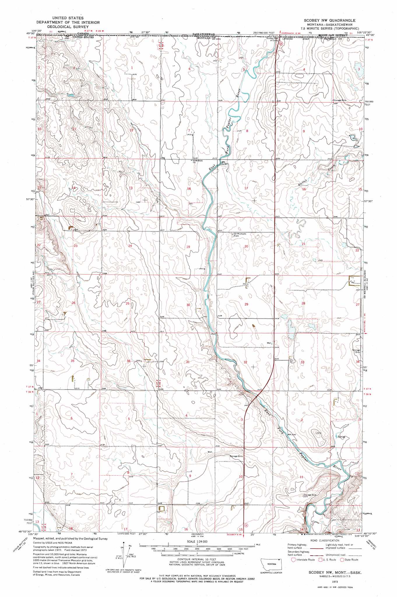
Scobey Nw Topo Map Montana
To zoom in, hover over the map of Scobey Nw
USGS Topo Quad 48105h4 - 1:24,000 scale
| Topo Map Name: | Scobey Nw |
| USGS Topo Quad ID: | 48105h4 |
| Print Size: | ca. 21 1/4" wide x 27" high |
| Southeast Coordinates: | 48.875° N latitude / 105.375° W longitude |
| Map Center Coordinates: | 48.9375° N latitude / 105.4375° W longitude |
| U.S. State: | MT |
| Filename: | o48105h4.jpg |
| Download Map JPG Image: | Scobey Nw topo map 1:24,000 scale |
| Map Type: | Topographic |
| Topo Series: | 7.5´ |
| Map Scale: | 1:24,000 |
| Source of Map Images: | United States Geological Survey (USGS) |
| Alternate Map Versions: |
Scobey NW MT 1973, updated 1976 Download PDF Buy paper map Scobey NW MT 2011 Download PDF Buy paper map Scobey NW MT 2014 Download PDF Buy paper map |
1:24,000 Topo Quads surrounding Scobey Nw
Four Buttes Nw |
Four Buttes Ne |
Scobey Nw |
Si Merrell Slough |
Whitetail |
Killenbeck Reservoir |
Four Buttes |
Scobey |
Madoc |
Flaxville |
Peerless 4 Nw |
Peerless 4 Ne |
Cabarett Coulee |
Line Coulee |
Pleasant Prairie Nw |
> Back to 48105e1 at 1:100,000 scale
> Back to 48104a1 at 1:250,000 scale
> Back to U.S. Topo Maps home
Scobey Nw topo map: Gazetteer
Scobey Nw: Streams
Outlet Creek elevation 735m 2411′Scobey Nw: Wells
36N47E01AAAC01 Well elevation 760m 2493′36N48E01BBCD01 Well elevation 742m 2434′
36N48E03ADAA01 Well elevation 732m 2401′
36N48E08AADA01 Well elevation 749m 2457′
36N48E08BBBC01 Well elevation 753m 2470′
36N48E08CCDD01 Well elevation 747m 2450′
36N48E09AAAD01 Well elevation 741m 2431′
36N48E09ACCA01 Well elevation 734m 2408′
36N48E09CDDC01 Well elevation 731m 2398′
36N48E11DCCA01 Well elevation 748m 2454′
36N48E15BABA01 Well elevation 738m 2421′
36N48E15BABB01 Well elevation 738m 2421′
36N48E16BBAC01 Well elevation 745m 2444′
36N48E16BBCB01 Well elevation 744m 2440′
36N48E18BDC_01 Well elevation 728m 2388′
36N48E18BDCC01 Well elevation 727m 2385′
36N48E18BDCD01 Well elevation 726m 2381′
37N47E01ABBB01 Well elevation 756m 2480′
37N47E01ABBB02 Well elevation 756m 2480′
37N47E01CABA01 Well elevation 756m 2480′
37N47E12BBBB01 Well elevation 771m 2529′
37N47E13AADD01 Well elevation 748m 2454′
37N47E13ADAA01 Well elevation 748m 2454′
37N47E22AAAA01 Well elevation 799m 2621′
37N47E23AAAC01 Well elevation 773m 2536′
37N47E23AAAD01 Well elevation 772m 2532′
37N47E23AADD02 Well elevation 771m 2529′
37N47E23BACD01 Well elevation 771m 2529′
37N47E23BADD01 Well elevation 775m 2542′
37N47E23BBBC01 Well elevation 781m 2562′
37N47E23DADB01 Well elevation 769m 2522′
37N47E35DCBC01 Well elevation 765m 2509′
37N47E36ACDD01 Well elevation 749m 2457′
37N47E36DABB01 Well elevation 755m 2477′
37N48E04BBBA01 Well elevation 744m 2440′
37N48E04BBBA02 Well elevation 744m 2440′
37N48E04DACC01 Well elevation 766m 2513′
37N48E05AAAA01 Well elevation 738m 2421′
37N48E05AADA01 Well elevation 744m 2440′
37N48E05BABB01 Well elevation 743m 2437′
37N48E05BCBB01 Well elevation 743m 2437′
37N48E06AABA01 Well elevation 747m 2450′
37N48E07DBBD01 Well elevation 742m 2434′
37N48E08CDCC01 Well elevation 740m 2427′
37N48E08CDCC02 Well elevation 739m 2424′
37N48E15CABC01 Well elevation 757m 2483′
37N48E18DDAD01 Well elevation 745m 2444′
37N48E19ACAD01 Well elevation 746m 2447′
37N48E19DDCB01 Well elevation 744m 2440′
37N48E19DDCC01 Well elevation 738m 2421′
37N48E21BCCD01 Well elevation 741m 2431′
37N48E21DBAA01 Well elevation 741m 2431′
37N48E22BABD01 Well elevation 742m 2434′
37N48E27BAAB01 Well elevation 742m 2434′
37N48E27BABD01 Well elevation 741m 2431′
37N48E27BACA01 Well elevation 741m 2431′
37N48E29AADA01 Well elevation 741m 2431′
37N48E30DBDA01 Well elevation 745m 2444′
37N48E32AADA01 Well elevation 742m 2434′
37N48E33BDCC01 Well elevation 738m 2421′
Scobey Nw digital topo map on disk
Buy this Scobey Nw topo map showing relief, roads, GPS coordinates and other geographical features, as a high-resolution digital map file on DVD:
Eastern Montana & Western North Dakota
Buy digital topo maps: Eastern Montana & Western North Dakota