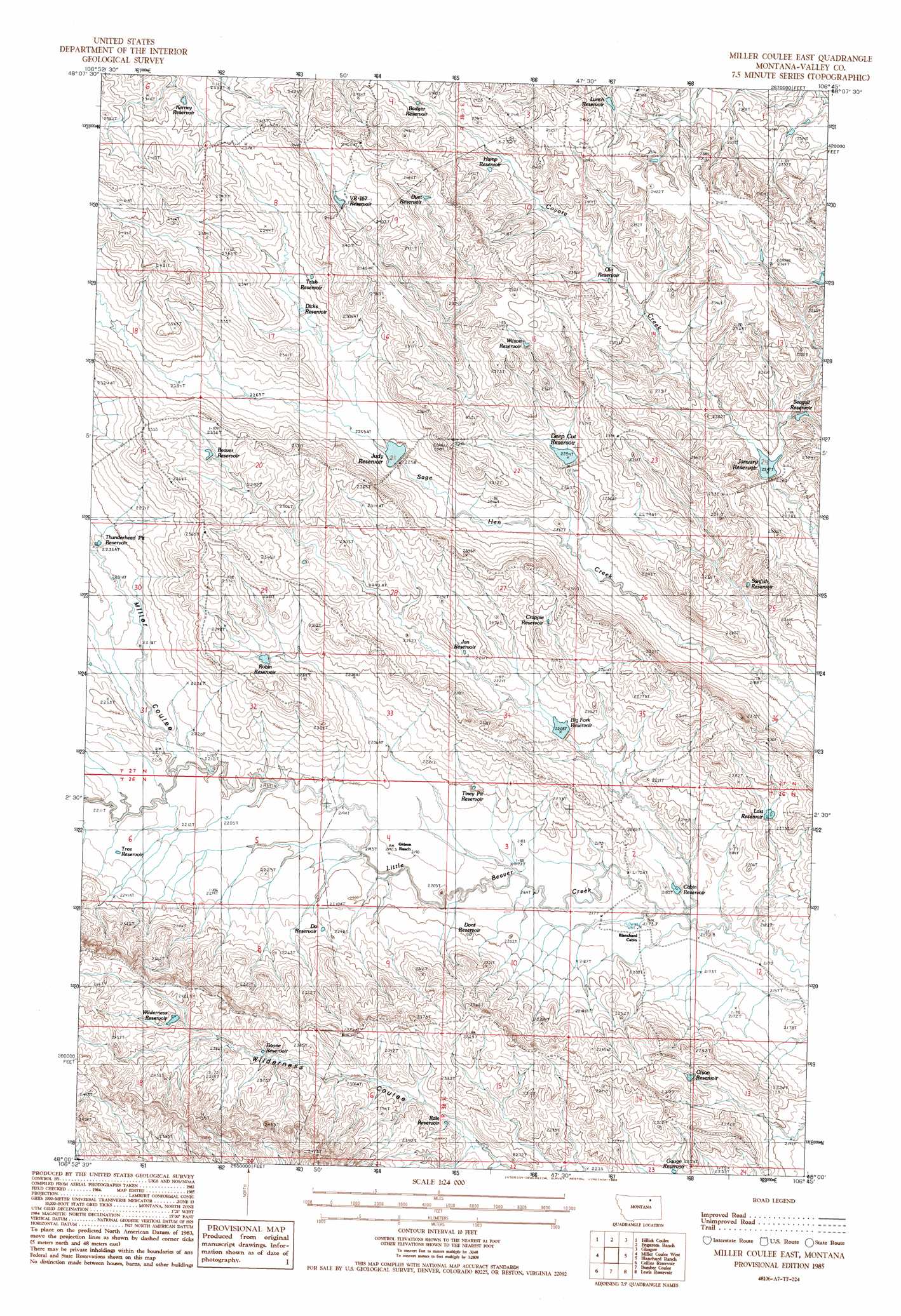
Miller Coulee East Topo Map Montana
To zoom in, hover over the map of Miller Coulee East
USGS Topo Quad 48106a7 - 1:24,000 scale
| Topo Map Name: | Miller Coulee East |
| USGS Topo Quad ID: | 48106a7 |
| Print Size: | ca. 21 1/4" wide x 27" high |
| Southeast Coordinates: | 48° N latitude / 106.75° W longitude |
| Map Center Coordinates: | 48.0625° N latitude / 106.8125° W longitude |
| U.S. State: | MT |
| Filename: | o48106a7.jpg |
| Download Map JPG Image: | Miller Coulee East topo map 1:24,000 scale |
| Map Type: | Topographic |
| Topo Series: | 7.5´ |
| Map Scale: | 1:24,000 |
| Source of Map Images: | United States Geological Survey (USGS) |
| Alternate Map Versions: |
Miller Coulee East MT 1985, updated 1986 Download PDF Buy paper map Miller Coulee East MT 2011 Download PDF Buy paper map Miller Coulee East MT 2014 Download PDF Buy paper map |
1:24,000 Topo Quads surrounding Miller Coulee East
Hinsdale Se |
Vandalia |
Tampico |
Chapman Coulee |
Hawk Coulee |
Hardpan Coulee |
Billick Coulee |
Engstrom Ranch |
Glasgow |
Whately |
Burnett Flats East |
Miller Coulee West |
Miller Coulee East |
Blanchard Ranch |
Wheeler |
Triple Crossing Res. East |
Collins Reservoir |
Bomber Coulee |
Lewis Reservoir |
Skunk Coulee |
Murray Hill |
Brown Pass |
Middle Eighth Coulee |
Seventh Point Buttes |
Sage Creek Point |
> Back to 48106a1 at 1:100,000 scale
> Back to 48106a1 at 1:250,000 scale
> Back to U.S. Topo Maps home
Miller Coulee East topo map: Gazetteer
Miller Coulee East: Dams
Beaver Tooth Dam elevation 658m 2158′Big Forks Dam elevation 674m 2211′
Deep Cut Dam elevation 678m 2224′
January Dam elevation 688m 2257′
Judy Dam elevation 687m 2253′
Sage Hen Reservoir Number 2 Dam elevation 733m 2404′
Wilderness Reservoir Dam elevation 674m 2211′
Miller Coulee East: Reservoirs
Badger Reservoir elevation 729m 2391′Beaver Reservoir elevation 707m 2319′
Big Fork Reservoir elevation 674m 2211′
Boone Reservoir elevation 712m 2335′
Cabin Reservoir elevation 662m 2171′
Crappie Reservoir elevation 699m 2293′
Deep Cut Reservoir elevation 688m 2257′
Dicks Reservoir elevation 696m 2283′
Do Reservoir elevation 680m 2230′
Dont Reservoir elevation 671m 2201′
Duet Reservoir elevation 741m 2431′
Gauge Reservoir elevation 677m 2221′
Hump Reservoir elevation 717m 2352′
Jan Reservoir elevation 680m 2230′
January Reservoir elevation 686m 2250′
Judy Reservoir elevation 685m 2247′
Keeney Reservoir elevation 710m 2329′
Kerney Reservoir elevation 711m 2332′
Last Reservoir elevation 678m 2224′
Lunch Reservoir elevation 719m 2358′
McIntyre Reservoir elevation 692m 2270′
Ola Reservoir elevation 708m 2322′
Olson Reservoir elevation 685m 2247′
Rain Reservoir elevation 693m 2273′
Robin Reservoir elevation 689m 2260′
Sage Hen Reservoir elevation 688m 2257′
Sage Hen Reservoir Number Two elevation 731m 2398′
Seagull Reservoir elevation 695m 2280′
Sunfish Reservoir elevation 680m 2230′
Thunderhead Pit Reservoir elevation 683m 2240′
Tiney Pit Reservoir elevation 671m 2201′
Tree Reservoir elevation 676m 2217′
Trish Reservoir elevation 704m 2309′
VR-167 Reservoir elevation 732m 2401′
Wilderness Reservoir elevation 726m 2381′
Wilson Reservoir elevation 721m 2365′
Miller Coulee East: Valleys
Miller Coulee elevation 680m 2230′Miller Coulee East digital topo map on disk
Buy this Miller Coulee East topo map showing relief, roads, GPS coordinates and other geographical features, as a high-resolution digital map file on DVD:
Eastern Montana & Western North Dakota
Buy digital topo maps: Eastern Montana & Western North Dakota