Spring Valley East Topo Map Montana
To zoom in, hover over the map of Spring Valley East
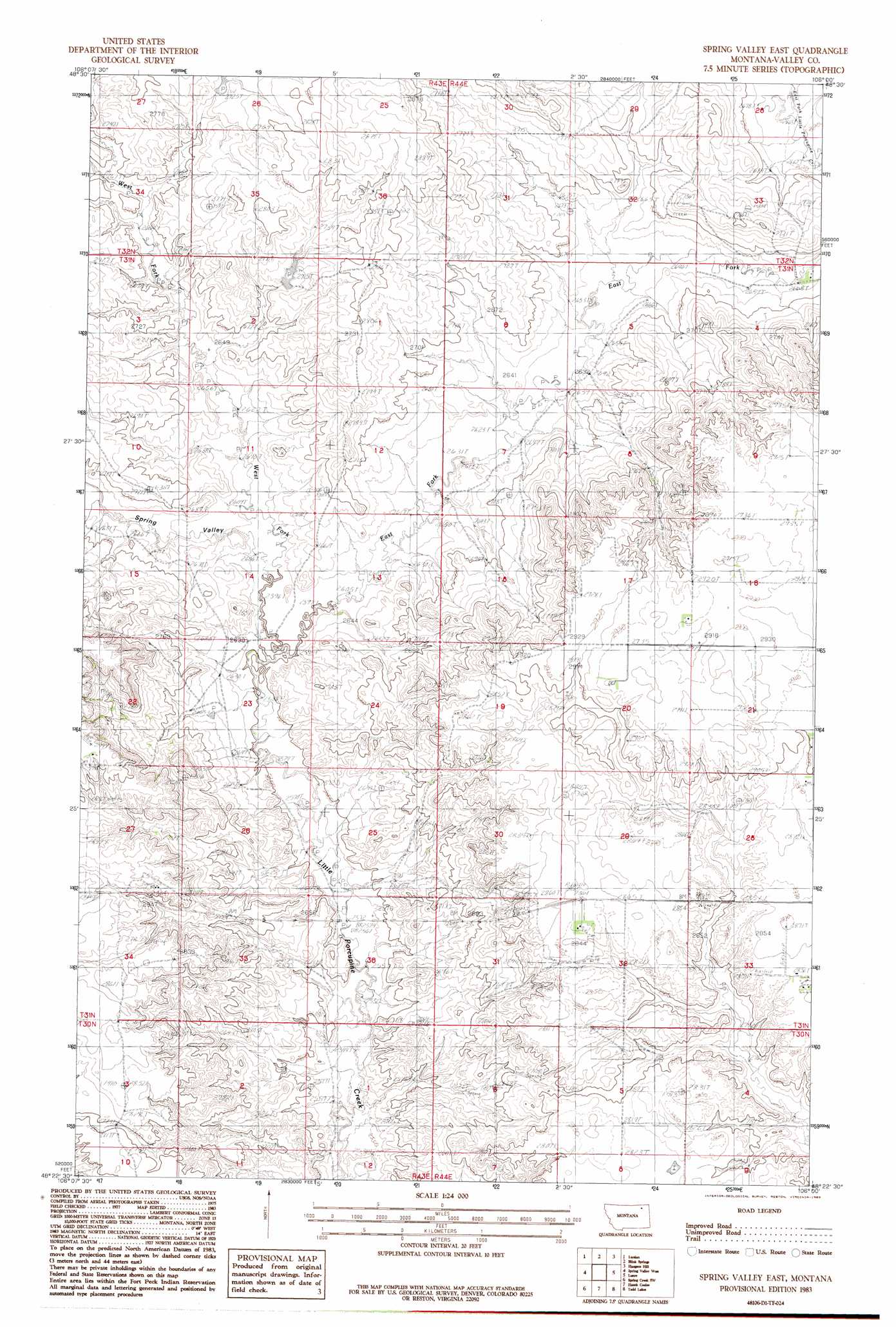
USGS Topo Quad 48106d1 - 1:24,000 scale
| Topo Map Name: | Spring Valley East |
| USGS Topo Quad ID: | 48106d1 |
| Print Size: | ca. 21 1/4" wide x 27" high |
| Southeast Coordinates: | 48.375° N latitude / 106° W longitude |
| Map Center Coordinates: | 48.4375° N latitude / 106.0625° W longitude |
| U.S. State: | MT |
| Filename: | o48106d1.jpg |
| Download Map JPG Image: | Spring Valley East topo map 1:24,000 scale |
| Map Type: | Topographic |
| Topo Series: | 7.5´ |
| Map Scale: | 1:24,000 |
| Source of Map Images: | United States Geological Survey (USGS) |
| Alternate Map Versions: |
Spring Valley East MT 1983, updated 1983 Download PDF Buy paper map Spring Valley East MT 2011 Download PDF Buy paper map Spring Valley East MT 2014 Download PDF Buy paper map |
1:24,000 Topo Quads surrounding Spring Valley East
Baylor Ne |
Larslan Nw |
Johnnys Hill |
West Fork |
West Fork Ne |
Baylor Se |
Larslan |
Blink Springs |
Haugens Hill |
Poplar Coulee |
Bullhead Reservoir |
Spring Valley West |
Spring Valley East |
Lustre |
Todd Lakes Ne |
Sargent Creek |
Spring Creek Sw |
Hauck Coulee |
Todd Lakes |
Todd Lakes Se |
Nashua |
Milk River Coulee |
Dubbe Reservoir |
Oswego Nw |
Flynn Creek North |
> Back to 48106a1 at 1:100,000 scale
> Back to 48106a1 at 1:250,000 scale
> Back to U.S. Topo Maps home
Spring Valley East topo map: Gazetteer
Spring Valley East: Airports
Olfert Airport elevation 873m 2864′Spring Valley East: Dams
Ghost Number 3 Dam elevation 837m 2746′Spring Valley East: Streams
East Fork Little Porcupine Creek elevation 794m 2604′East Fork Little Porcupine Creek elevation 813m 2667′
West Fork Little Porcupine Creek elevation 794m 2604′
Spring Valley East: Valleys
Spring Valley elevation 794m 2604′Spring Valley East: Wells
31N44E04AAAC01 Well elevation 814m 2670′31N44E17DDAA01 Well elevation 894m 2933′
31N44E20BDBD01 Well elevation 896m 2939′
31N44E28AAAB01 Well elevation 883m 2896′
31N44E28AAAC01 Well elevation 883m 2896′
31N44E33DABA01 Well elevation 870m 2854′
31N44E33DADA01 Well elevation 873m 2864′
Spring Valley East digital topo map on disk
Buy this Spring Valley East topo map showing relief, roads, GPS coordinates and other geographical features, as a high-resolution digital map file on DVD:
Eastern Montana & Western North Dakota
Buy digital topo maps: Eastern Montana & Western North Dakota