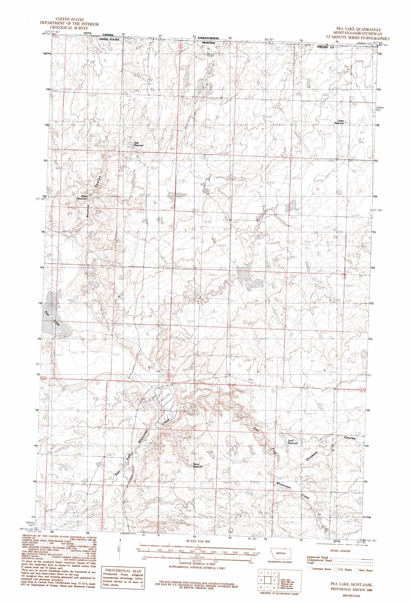
Pea Lake Topo Map Montana
To zoom in, hover over the map of Pea Lake
USGS Topo Quad 48107h5 - 1:24,000 scale
| Topo Map Name: | Pea Lake |
| USGS Topo Quad ID: | 48107h5 |
| Print Size: | ca. 21 1/4" wide x 27" high |
| Southeast Coordinates: | 48.875° N latitude / 107.5° W longitude |
| Map Center Coordinates: | 48.9375° N latitude / 107.5625° W longitude |
| U.S. State: | MT |
| Filename: | o48107h5.jpg |
| Download Map JPG Image: | Pea Lake topo map 1:24,000 scale |
| Map Type: | Topographic |
| Topo Series: | 7.5´ |
| Map Scale: | 1:24,000 |
| Source of Map Images: | United States Geological Survey (USGS) |
| Alternate Map Versions: |
Pea Lake MT 1984, updated 1984 Download PDF Buy paper map Pea Lake MT 2011 Download PDF Buy paper map Pea Lake MT 2014 Download PDF Buy paper map |
1:24,000 Topo Quads surrounding Pea Lake
Morgan |
Gustin Coulee |
Pea Lake |
Thoeny Hills West |
Thoeny Hills East |
Loring |
Whitewater West |
Whitewater East |
Salsbery Reservoir |
Dead Horse Coulee |
Austin Coulee |
Austin Lake |
Tattnall |
Forks |
Porcupine Coulee |
> Back to 48107e1 at 1:100,000 scale
> Back to 48106a1 at 1:250,000 scale
> Back to U.S. Topo Maps home
Pea Lake topo map: Gazetteer
Pea Lake: Dams
PR-156 Dam elevation 787m 2582′PR-88 Dam elevation 785m 2575′
Pea Lake: Lakes
Pea Lake elevation 748m 2454′Pea Lake: Post Offices
Corwine Center Post Office (historical) elevation 801m 2627′Pea Lake: Reservoirs
Artie Reservoir elevation 806m 2644′Ethel Reservoir elevation 772m 2532′
Lester Reservoir elevation 801m 2627′
Nerve Reservoir elevation 781m 2562′
Sarm Reservoir elevation 805m 2641′
Pea Lake: Valleys
Dunham Coulee elevation 795m 2608′Gustin Coulee elevation 741m 2431′
Haukos Coulee elevation 751m 2463′
Voje Coulee elevation 809m 2654′
Pea Lake: Wells
37N32E19AAA_01 Well elevation 812m 2664′Pea Lake digital topo map on disk
Buy this Pea Lake topo map showing relief, roads, GPS coordinates and other geographical features, as a high-resolution digital map file on DVD:
Eastern Montana & Western North Dakota
Buy digital topo maps: Eastern Montana & Western North Dakota