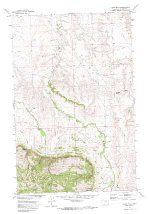
Lodge Pole Topo Map Montana
To zoom in, hover over the map of Lodge Pole
USGS Topo Quad 48108a5 - 1:24,000 scale
| Topo Map Name: | Lodge Pole |
| USGS Topo Quad ID: | 48108a5 |
| Print Size: | ca. 21 1/4" wide x 27" high |
| Southeast Coordinates: | 48° N latitude / 108.5° W longitude |
| Map Center Coordinates: | 48.0625° N latitude / 108.5625° W longitude |
| U.S. State: | MT |
| Filename: | o48108a5.jpg |
| Download Map JPG Image: | Lodge Pole topo map 1:24,000 scale |
| Map Type: | Topographic |
| Topo Series: | 7.5´ |
| Map Scale: | 1:24,000 |
| Source of Map Images: | United States Geological Survey (USGS) |
| Alternate Map Versions: |
Lodge Pole MT 1971, updated 1974 Download PDF Buy paper map Lodge Pole MT 2011 Download PDF Buy paper map Lodge Pole MT 2014 Download PDF Buy paper map |
1:24,000 Topo Quads surrounding Lodge Pole
> Back to 48108a1 at 1:100,000 scale
> Back to 48108a1 at 1:250,000 scale
> Back to U.S. Topo Maps home
Lodge Pole topo map: Gazetteer
Lodge Pole: Dams
Kirkaldie Dam elevation 1013m 3323′Lodge Pole: Populated Places
Lodge Pole elevation 1039m 3408′Lodge Pole: Post Offices
Lodge Pole Post Office (historical) elevation 1039m 3408′Lodge Pole: Ranges
Little Rocky Mountains elevation 1381m 4530′Lodge Pole: Springs
Blackbull Spring elevation 1043m 3421′Lodge Pole: Summits
Mouse Butte elevation 1304m 4278′Lodge Pole: Valleys
Jim Brown Canyon elevation 1113m 3651′Mouse Canyon elevation 1124m 3687′
Valentine Canyon elevation 1123m 3684′
White Horse Canyon elevation 1086m 3562′
Lodge Pole: Wells
26N24E02ACB_01 Well elevation 1054m 3458′26N25E05ACAD01 Well elevation 1043m 3421′
26N25E05BDDA01 Well elevation 1030m 3379′
26N25E05BDDA02 Well elevation 1033m 3389′
26N25E05BDDD01 Well elevation 1032m 3385′
26N25E05CAA_01 Well elevation 1031m 3382′
26N25E05CAA_02 Well elevation 1032m 3385′
26N25E05CAA_03 Well elevation 1032m 3385′
26N25E05CAAA01 Well elevation 1032m 3385′
26N25E05CAAA02 Well elevation 1032m 3385′
26N25E05CAAA03 Well elevation 1032m 3385′
26N25E05CAAA04 Well elevation 1032m 3385′
26N25E05CABD01 Well elevation 1033m 3389′
26N25E05CACA01 Well elevation 1036m 3398′
26N25E05CAD_01 Well elevation 1035m 3395′
26N25E05CAD_02 Well elevation 1035m 3395′
26N25E05CAD_03 Well elevation 1036m 3398′
26N25E05CADA01 Well elevation 1035m 3395′
26N25E05CBC_01 Well elevation 1035m 3395′
26N25E05CCA_01 Well elevation 1046m 3431′
26N25E05CCB_01 Well elevation 1047m 3435′
26N25E05CDA_01 Well elevation 1039m 3408′
26N25E05CDA_02 Well elevation 1039m 3408′
26N25E05CDA_03 Well elevation 1038m 3405′
26N25E05CDBD01 Well elevation 1042m 3418′
26N25E05CDC_01 Well elevation 1049m 3441′
26N25E05CDC_02 Well elevation 1047m 3435′
26N25E05CDC_03 Well elevation 1044m 3425′
26N25E05CDC_04 Well elevation 1043m 3421′
26N25E05DCC_01 Well elevation 1042m 3418′
26N25E06ACB_01 Well elevation 1024m 3359′
26N25E08ABA_01 Well elevation 1044m 3425′
26N25E08ABA_02 Well elevation 1044m 3425′
26N25E08BAB_01 Well elevation 1044m 3425′
26N25E08BAB_02 Well elevation 1045m 3428′
26N25E08BAD_01 Well elevation 1047m 3435′
26N25E08BBDA01 Well elevation 1051m 3448′
26N25E08BCA_01 Well elevation 1051m 3448′
26N25E08BCA_02 Well elevation 1054m 3458′
26N25E08BCDB01 Well elevation 1058m 3471′
26N25E08BDA_01 Well elevation 1051m 3448′
26N25E08BDAC01 Well elevation 1051m 3448′
26N25E08BDBC01 Well elevation 1050m 3444′
26N25E08BDC_01 Well elevation 1053m 3454′
26N25E08BDC_02 Well elevation 1055m 3461′
26N25E08BDC_03 Well elevation 1053m 3454′
26N25E08CCAA01 Well elevation 1060m 3477′
26N25E08DBC_01 Well elevation 1059m 3474′
26N25E08DCDC01 Well elevation 1068m 3503′
26N25E17ABBB01 Well elevation 1068m 3503′
26N25E17ABBB02 Well elevation 1068m 3503′
26N25E17BAAA01 Well elevation 1070m 3510′
26N25E17BCAB01 Well elevation 1087m 3566′
26N25E17CDD_01 Well elevation 1101m 3612′
26N25E17DACB01 Well elevation 1087m 3566′
26N25E20BABA01 Well elevation 1105m 3625′
26N25E20BABA02 Well elevation 1107m 3631′
27N24E01CDAA01 Well elevation 915m 3001′
27N24E13CCDA01 Well elevation 946m 3103′
27N24E13CCDB01 Well elevation 944m 3097′
27N24E13CCDB02 Well elevation 944m 3097′
27N24E13CCDB03 Well elevation 942m 3090′
27N24E13CDCB01 Well elevation 952m 3123′
27N24E26ABDC01 Well elevation 972m 3188′
27N24E26ADCA01 Well elevation 977m 3205′
27N24E26ADCD01 Well elevation 976m 3202′
27N24E26DADC01 Well elevation 1003m 3290′
27N24E35CCAB01 Well elevation 1026m 3366′
27N24E35CDBC01 Well elevation 1034m 3392′
27N24E35CDC_01 Well elevation 1030m 3379′
27N24E36DAAC01 Well elevation 1007m 3303′
27N24E36DAAC02 Well elevation 1008m 3307′
27N24E36DAAC03 Well elevation 1008m 3307′
27N25E20BCA_01 Well elevation 987m 3238′
27N25E20BCD_01 Well elevation 997m 3270′
27N25E29BDBA01 Well elevation 1018m 3339′
27N25E29CDDD01 Well elevation 1039m 3408′
27N25E31BCCD01 Well elevation 1012m 3320′
27N25E31CDDB01 Well elevation 1022m 3353′
27N25E32CCC_01 Well elevation 1020m 3346′
Lodge Pole digital topo map on disk
Buy this Lodge Pole topo map showing relief, roads, GPS coordinates and other geographical features, as a high-resolution digital map file on DVD:


