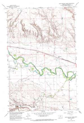
Fort Belknap Siding Topo Map Montana
To zoom in, hover over the map of Fort Belknap Siding
USGS Topo Quad 48108e8 - 1:24,000 scale
| Topo Map Name: | Fort Belknap Siding |
| USGS Topo Quad ID: | 48108e8 |
| Print Size: | ca. 21 1/4" wide x 27" high |
| Southeast Coordinates: | 48.5° N latitude / 108.875° W longitude |
| Map Center Coordinates: | 48.5625° N latitude / 108.9375° W longitude |
| U.S. State: | MT |
| Filename: | o48108e8.jpg |
| Download Map JPG Image: | Fort Belknap Siding topo map 1:24,000 scale |
| Map Type: | Topographic |
| Topo Series: | 7.5´ |
| Map Scale: | 1:24,000 |
| Source of Map Images: | United States Geological Survey (USGS) |
| Alternate Map Versions: |
Fort Belknap Siding MT 1964, updated 1967 Download PDF Buy paper map Fort Belknap Siding MT 2011 Download PDF Buy paper map Fort Belknap Siding MT 2014 Download PDF Buy paper map |
1:24,000 Topo Quads surrounding Fort Belknap Siding
> Back to 48108e1 at 1:100,000 scale
> Back to 48108a1 at 1:250,000 scale
> Back to U.S. Topo Maps home
Fort Belknap Siding topo map: Gazetteer
Fort Belknap Siding: Bridges
Milk River Bridge elevation 719m 2358′Fort Belknap Siding: Canals
Snake Creek Ditch elevation 724m 2375′Fort Belknap Siding: Dams
Chuck Dam elevation 721m 2365′Miller Dam elevation 731m 2398′
Fort Belknap Siding: Streams
Nessler Creek elevation 720m 2362′Snake Creek elevation 717m 2352′
Fort Belknap Siding: Valleys
Dry Coulee elevation 733m 2404′Murphy Coulee elevation 746m 2447′
Zualtieri Coulee elevation 732m 2401′
Fort Belknap Siding: Wells
32N21E01CBAD01 Well elevation 723m 2372′32N21E10BBDB01 Well elevation 725m 2378′
32N22E16CCD_01 Well elevation 721m 2365′
Fort Belknap Siding digital topo map on disk
Buy this Fort Belknap Siding topo map showing relief, roads, GPS coordinates and other geographical features, as a high-resolution digital map file on DVD:


