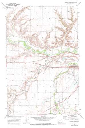
Herron Park Topo Map Montana
To zoom in, hover over the map of Herron Park
USGS Topo Quad 48109e7 - 1:24,000 scale
| Topo Map Name: | Herron Park |
| USGS Topo Quad ID: | 48109e7 |
| Print Size: | ca. 21 1/4" wide x 27" high |
| Southeast Coordinates: | 48.5° N latitude / 109.75° W longitude |
| Map Center Coordinates: | 48.5625° N latitude / 109.8125° W longitude |
| U.S. State: | MT |
| Filename: | o48109e7.jpg |
| Download Map JPG Image: | Herron Park topo map 1:24,000 scale |
| Map Type: | Topographic |
| Topo Series: | 7.5´ |
| Map Scale: | 1:24,000 |
| Source of Map Images: | United States Geological Survey (USGS) |
| Alternate Map Versions: |
Herron Park MT 1970, updated 1973 Download PDF Buy paper map Herron Park MT 1970, updated 1978 Download PDF Buy paper map Herron Park MT 2011 Download PDF Buy paper map Herron Park MT 2014 Download PDF Buy paper map |
1:24,000 Topo Quads surrounding Herron Park
> Back to 48109e1 at 1:100,000 scale
> Back to 48108a1 at 1:250,000 scale
> Back to U.S. Topo Maps home
Herron Park topo map: Gazetteer
Herron Park: Airports
Havre City/County Airport elevation 788m 2585′Herron Park: Areas
Milk River Badlands elevation 807m 2647′Herron Park: Canals
Havre Irrigation Ditch elevation 808m 2650′Meill Ditch elevation 767m 2516′
Herron Park: Dams
Capudj Dam elevation 764m 2506′Mission Mountain Dam elevation 776m 2545′
Herron Park: Lakes
Halfway Lake elevation 786m 2578′Stink Lake elevation 792m 2598′
Herron Park: Oilfields
Tiger Ridge Gas Field elevation 789m 2588′Herron Park: Parks
Fort Assinniboine Historical Marker elevation 806m 2644′Herron Park: Populated Places
Beaver Creek elevation 786m 2578′Cypress (historical) elevation 759m 2490′
Herron elevation 793m 2601′
Pacific Junction elevation 769m 2522′
Herron Park: Post Offices
Fort Assinniboine Post Office (historical) elevation 814m 2670′Herron Park: Streams
Big Sandy Creek elevation 757m 2483′Herron Park: Summits
Black Butte elevation 835m 2739′Herron Park: Valleys
Cherry Coulee elevation 767m 2516′Duncan Coulee elevation 764m 2506′
Fielding Coulee elevation 771m 2529′
Fresno Coulee elevation 765m 2509′
Harroum Coulee elevation 825m 2706′
Indian Woman Coulee elevation 796m 2611′
Meili Coulee elevation 766m 2513′
Neal Coulee elevation 773m 2536′
Rattlesnake Coulee elevation 769m 2522′
Sprinkle Coulee elevation 769m 2522′
Supenau Coulee elevation 770m 2526′
Herron Park: Wells
32N14E25BB__01 Well elevation 791m 2595′32N14E25DA__01 Well elevation 791m 2595′
32N15E17DD__01 Well elevation 788m 2585′
32N15E17DDDC01 Well elevation 787m 2582′
32N15E21BB__01 Well elevation 789m 2588′
32N15E28ACAA01 Well elevation 798m 2618′
32N15E28ACDA01 Well elevation 798m 2618′
32N15E28ADCD01 Well elevation 800m 2624′
32N15E29ADDA01 Well elevation 807m 2647′
32N15E29ADDA02 Well elevation 808m 2650′
32N15E29ADDB01 Well elevation 808m 2650′
32N15E29ADDC01 Well elevation 808m 2650′
32N15E29ADDD01 Well elevation 809m 2654′
Herron Park digital topo map on disk
Buy this Herron Park topo map showing relief, roads, GPS coordinates and other geographical features, as a high-resolution digital map file on DVD:


