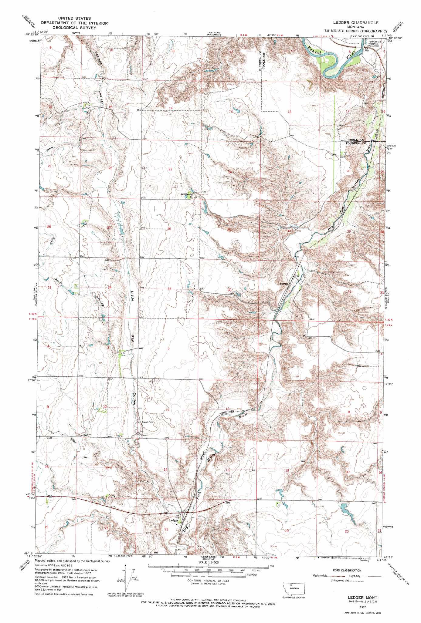
Ledger Topo Map Montana
To zoom in, hover over the map of Ledger
USGS Topo Quad 48111c7 - 1:24,000 scale
| Topo Map Name: | Ledger |
| USGS Topo Quad ID: | 48111c7 |
| Print Size: | ca. 21 1/4" wide x 27" high |
| Southeast Coordinates: | 48.25° N latitude / 111.75° W longitude |
| Map Center Coordinates: | 48.3125° N latitude / 111.8125° W longitude |
| U.S. State: | MT |
| Filename: | o48111c7.jpg |
| Download Map JPG Image: | Ledger topo map 1:24,000 scale |
| Map Type: | Topographic |
| Topo Series: | 7.5´ |
| Map Scale: | 1:24,000 |
| Source of Map Images: | United States Geological Survey (USGS) |
| Alternate Map Versions: |
Ledger MT 1967, updated 1971 Download PDF Buy paper map Ledger MT 2011 Download PDF Buy paper map Ledger MT 2014 Download PDF Buy paper map |
1:24,000 Topo Quads surrounding Ledger
Ethridge |
Virden |
Shelby |
Antelope Coulee Sw |
Antelope Coulee Se |
Cactus Flat |
Ledger Nw |
Naismith |
Dunkirk |
South Devon School |
Belgian Hill |
Pioneer School |
Ledger |
Conrad Butte |
Central School |
Sam George Hill |
Conrad |
Letz Lake |
Fowler Coulee Nw |
Fowler Coulee Ne |
Gallup City |
Conrad Sw |
Brady |
Fowler Coulee Sw |
Fowler Coulee Se |
> Back to 48111a1 at 1:100,000 scale
> Back to 48110a1 at 1:250,000 scale
> Back to U.S. Topo Maps home
Ledger topo map: Gazetteer
Ledger: Canals
F Four Ditch elevation 1059m 3474′S Canal elevation 1093m 3585′
Ledger: Dams
Cracker Dam elevation 1021m 3349′Tom McCracken Dam elevation 1024m 3359′
Ledger: Parks
Fort Conrad Historical Monument elevation 927m 3041′Ledger: Populated Places
Fowler elevation 961m 3152′Ledger elevation 995m 3264′
Ledger: Post Offices
Conrad Post Office (historical) elevation 927m 3041′Fowler Post Office (historical) elevation 962m 3156′
Ledger Post Office elevation 995m 3264′
Ledger: Valleys
Little Flat Coulee elevation 989m 3244′Swift Coulee elevation 1039m 3408′
Ledger digital topo map on disk
Buy this Ledger topo map showing relief, roads, GPS coordinates and other geographical features, as a high-resolution digital map file on DVD: