Naismith Topo Map Montana
To zoom in, hover over the map of Naismith
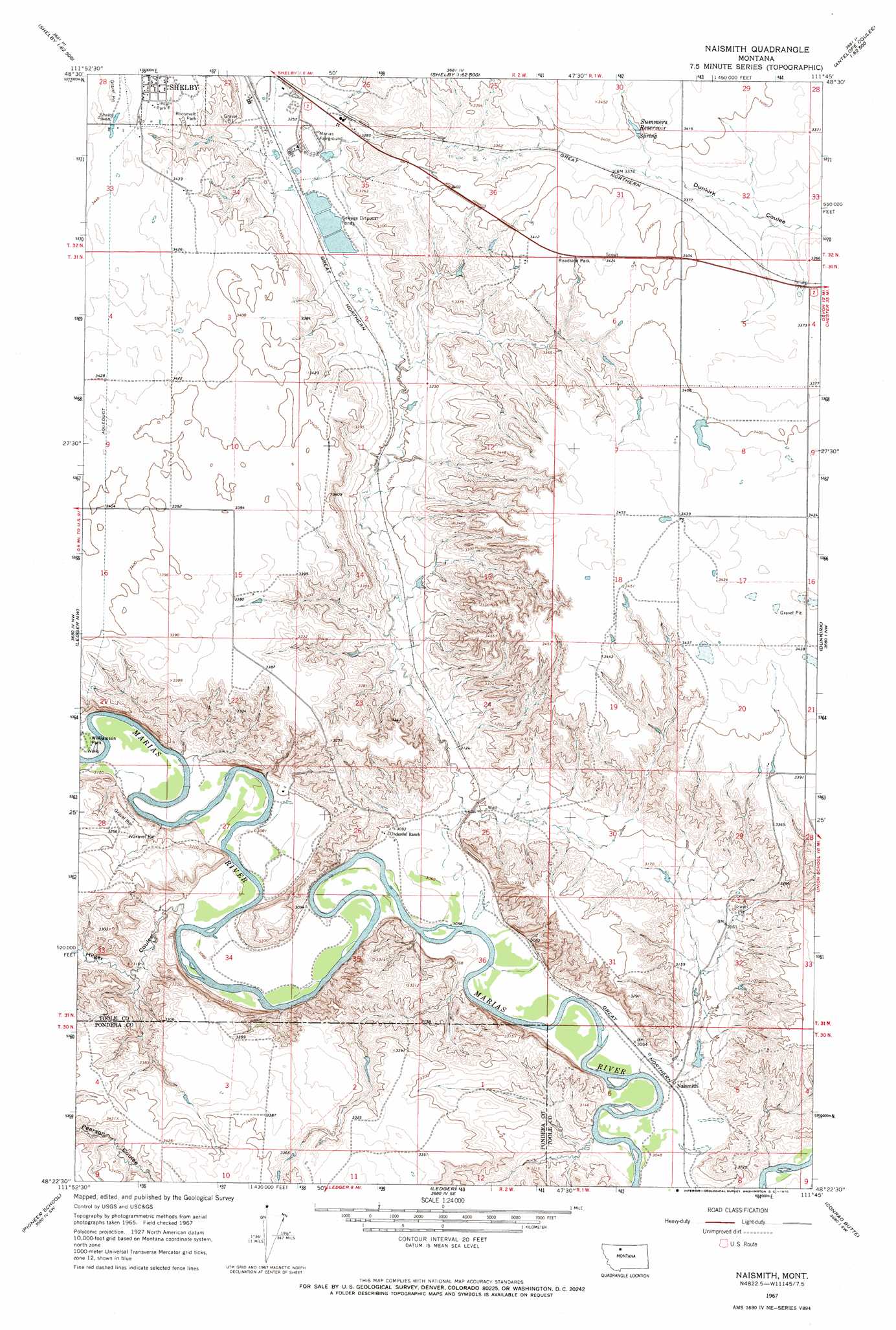
USGS Topo Quad 48111d7 - 1:24,000 scale
| Topo Map Name: | Naismith |
| USGS Topo Quad ID: | 48111d7 |
| Print Size: | ca. 21 1/4" wide x 27" high |
| Southeast Coordinates: | 48.375° N latitude / 111.75° W longitude |
| Map Center Coordinates: | 48.4375° N latitude / 111.8125° W longitude |
| U.S. State: | MT |
| Filename: | o48111d7.jpg |
| Download Map JPG Image: | Naismith topo map 1:24,000 scale |
| Map Type: | Topographic |
| Topo Series: | 7.5´ |
| Map Scale: | 1:24,000 |
| Source of Map Images: | United States Geological Survey (USGS) |
| Alternate Map Versions: |
Naismith MT 1967, updated 1970 Download PDF Buy paper map Naismith MT 2011 Download PDF Buy paper map Naismith MT 2014 Download PDF Buy paper map |
1:24,000 Topo Quads surrounding Naismith
Aloe |
Kevin South |
Oilmont |
Antelope Coulee Nw |
Johannson Coulee |
Ethridge |
Virden |
Shelby |
Antelope Coulee Sw |
Antelope Coulee Se |
Cactus Flat |
Ledger Nw |
Naismith |
Dunkirk |
South Devon School |
Belgian Hill |
Pioneer School |
Ledger |
Conrad Butte |
Central School |
Sam George Hill |
Conrad |
Letz Lake |
Fowler Coulee Nw |
Fowler Coulee Ne |
> Back to 48111a1 at 1:100,000 scale
> Back to 48110a1 at 1:250,000 scale
> Back to U.S. Topo Maps home
Naismith topo map: Gazetteer
Naismith: Dams
Ovens Dam elevation 940m 3083′Shelby Sewage Lagoon Dam elevation 983m 3225′
Naismith: Parks
Lincoln Park elevation 1048m 3438′Oily Boid Gets the Woim Historical Marker elevation 999m 3277′
Roosevelt Park elevation 1037m 3402′
Williamson Park elevation 944m 3097′
Naismith: Populated Places
Naismith elevation 931m 3054′Naismith: Reservoirs
Ovens Reservoir elevation 940m 3083′Summers Reservoir elevation 1032m 3385′
Naismith: Valleys
Hilger Coulee elevation 939m 3080′Naismith: Wells
32N02W27DDDD01 Well elevation 994m 3261′Naismith digital topo map on disk
Buy this Naismith topo map showing relief, roads, GPS coordinates and other geographical features, as a high-resolution digital map file on DVD: