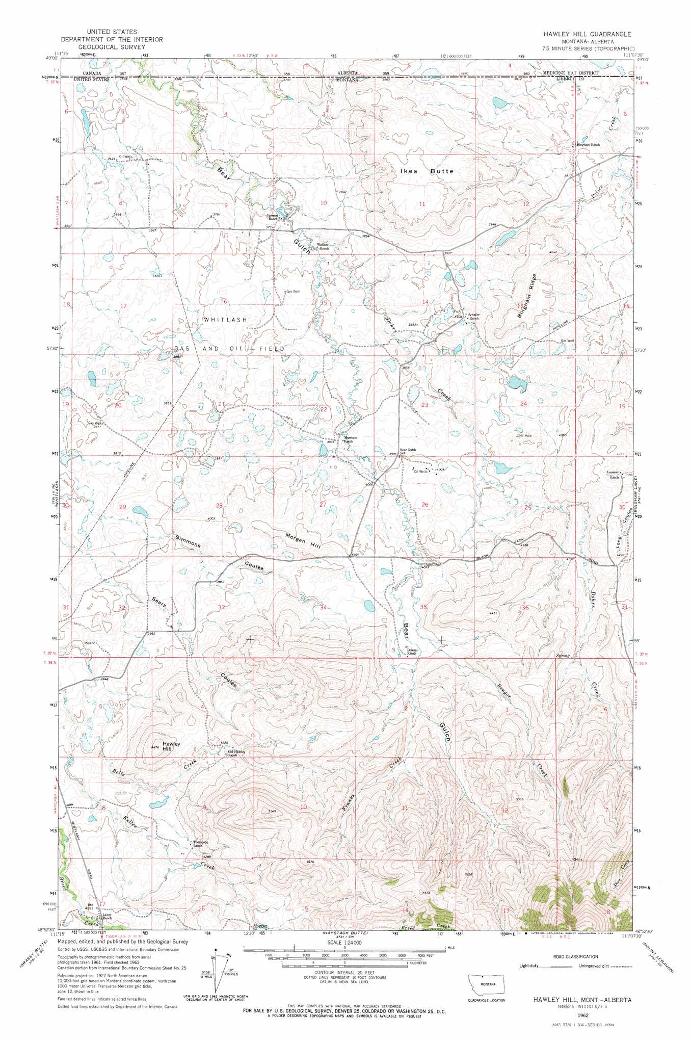
Hawley Hill Topo Map Montana
To zoom in, hover over the map of Hawley Hill
USGS Topo Quad 48111h2 - 1:24,000 scale
| Topo Map Name: | Hawley Hill |
| USGS Topo Quad ID: | 48111h2 |
| Print Size: | ca. 21 1/4" wide x 27" high |
| Southeast Coordinates: | 48.875° N latitude / 111.125° W longitude |
| Map Center Coordinates: | 48.9375° N latitude / 111.1875° W longitude |
| U.S. State: | MT |
| Filename: | o48111h2.jpg |
| Download Map JPG Image: | Hawley Hill topo map 1:24,000 scale |
| Map Type: | Topographic |
| Topo Series: | 7.5´ |
| Map Scale: | 1:24,000 |
| Source of Map Images: | United States Geological Survey (USGS) |
| Alternate Map Versions: |
Hawley Hill MT 1962, updated 1964 Download PDF Buy paper map Hawley Hill MT 2011 Download PDF Buy paper map Hawley Hill MT 2014 Download PDF Buy paper map |
1:24,000 Topo Quads surrounding Hawley Hill
Fey Lakes |
Whitlash |
Hawley Hill |
Bingham Lake |
Laird School |
Cameron Lake |
Grassy Butte |
Haystack Butte |
Mount Lebanon |
Vaver Reservoir |
Hawthorne School |
Berkholder Reservoir |
Blair Ranch |
Lakey Ranch |
Chester Nw |
> Back to 48111e1 at 1:100,000 scale
> Back to 48110a1 at 1:250,000 scale
> Back to U.S. Topo Maps home
Hawley Hill topo map: Gazetteer
Hawley Hill: Dams
Betelguese Dam elevation 1224m 4015′Closed Doors Dam elevation 1220m 4002′
Famolare Dam elevation 1214m 3982′
Menkar Dam elevation 1311m 4301′
Parsell Dam elevation 1225m 4019′
W Parsell Dam elevation 1238m 4061′
Hawley Hill: Mines
Mount Brown Mine elevation 1597m 5239′Hawley Hill: Oilfields
Whitlash Gas and Oil Field elevation 1145m 3756′Hawley Hill: Ridges
Bingham Ridge elevation 1249m 4097′Hawley Hill: Springs
36N04E09CDDB01 Spring elevation 1287m 4222′Hawley Hill: Streams
Bengor Creek elevation 1243m 4078′Dohrs Creek elevation 1133m 3717′
Franks Creek elevation 1298m 4258′
Hawley Hill: Summits
Hawley Hill elevation 1362m 4468′Ikes Butte elevation 1264m 4146′
Morgan Hill elevation 1277m 4189′
Hawley Hill: Wells
36N04E05CDAC01 Well elevation 1216m 3989′36N04E08BAAC01 Well elevation 1236m 4055′
36N04E17CAA01_ Well elevation 1272m 4173′
37N04E01DDDA01 Well elevation 1154m 3786′
37N04E04CBDA01 Well elevation 1098m 3602′
37N04E09DADA01 Well elevation 1130m 3707′
37N04E10CBCA01 Well elevation 1129m 3704′
37N04E11DCCD01 Well elevation 1201m 3940′
37N04E12ABCA01 Well elevation 1183m 3881′
37N04E14ADAC01 Well elevation 1196m 3923′
37N04E14DDAB01 Well elevation 1195m 3920′
37N04E15DCDB01 Well elevation 1168m 3832′
37N04E22DCAB01 Well elevation 1196m 3923′
37N04E23CCDD01 Well elevation 1219m 3999′
37N04E26BDCC01 Well elevation 1228m 4028′
37N04E35CDDD01 Well elevation 1275m 4183′
37N05E30BAD01_ Well elevation 1255m 4117′
Hawley Hill digital topo map on disk
Buy this Hawley Hill topo map showing relief, roads, GPS coordinates and other geographical features, as a high-resolution digital map file on DVD: